Spatial hotspot analysis of soil erosion rate and classification of homogeneous zones using GIS in a mountainous contrasting land-use watershed
Fatemeh Saeedi Nazarlu, Hassan Khavarian Nehzak, Raoof Mostafazadeh, Nazila Alaei

TL;DR
This study uses GIS to analyze soil erosion in a mountainous watershed in Iran, identifying hotspots and suggesting targeted land management strategies.
Contribution
The study introduces a spatial hotspot analysis approach for classifying erosion-prone zones in a contrasting land-use watershed.
Findings
Over 65% of the watershed has moderate to very high erosion rates, averaging 7-ton ha⁻¹ year⁻¹.
High erosion hotspots (HH clusters) are located in the southwest, while low erosion coldspots (LL clusters) are in the north and northeast.
Erosion is most severe in areas with heavy rainfall, steep slopes, fine soils, and sparse vegetation.
Abstract
Soil erosion poses a significant challenge to environmental sustainability, especially in regions with varying land-use patterns and topography. Soil erosion is a major environmental threat affecting soil quality, reservoir sedimentation, agricultural land, and watershed hydrology. This study aims to identify and classify homogeneous sub-watersheds in a mountainous watershed in Iran using GIS. Forty years of climate data, a high-resolution DEM, land-use maps, soil texture, and NDVI were applied to derive the main factors, while the P factor was determined based on slope classes and land-use types. The RUSLE results showed that annual soil erosion in the watershed had an average of about 7-ton ha⁻¹ year⁻¹, with more than 65% of the watershed area falling into the moderate to very high erosion classes. Average key factors were R = 78.08 MJ·mm/ha·hr·year, K = 0.28 t·ha·h/MJ·mm·ha, LS =…
Genes, proteins, chemicals, diseases, species, mutations and cell lines named across the full text — each resolved to its canonical identifier and authoritative record.
Click any figure to enlarge with its caption.
 Figure 1
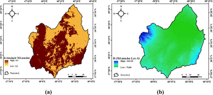 Figure 2
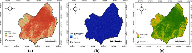 Figure 3
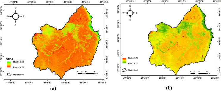 Figure 4
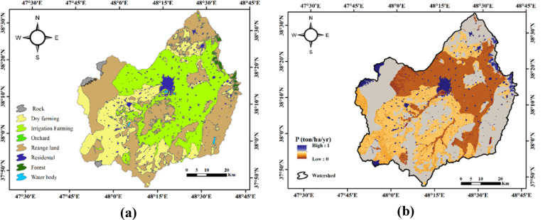 Figure 5
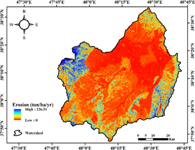 Figure 6
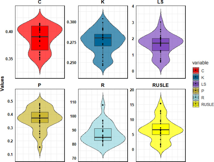 Figure 7
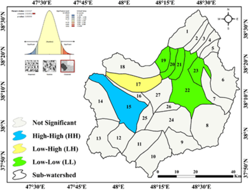 Figure 8
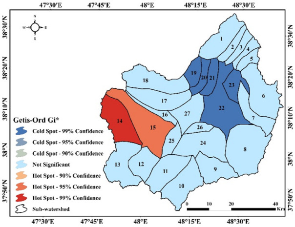 Figure 9
Peer Reviews
No public reviews on file for this paper yet. If you reviewed it on a platform where reviews are public (OpenReview, ICLR, NeurIPS, ICML), you can paste yours below so the community can read it here.
Videos
No videos yet. Explain this paper in a talk, walkthrough, or lecture? Add one.
Taxonomy
TopicsSoil erosion and sediment transport · Groundwater and Watershed Analysis · Land Use and Ecosystem Services