Development and utilization of an open-data, web-based geographic information system to support the response to the 2024 Noto Peninsula earthquake, Japan
Ryo Horiike, Tomoya Itatani, Hisao Nakai, Kentaro Tanaka
Abstract
Click any figure to enlarge with its caption.
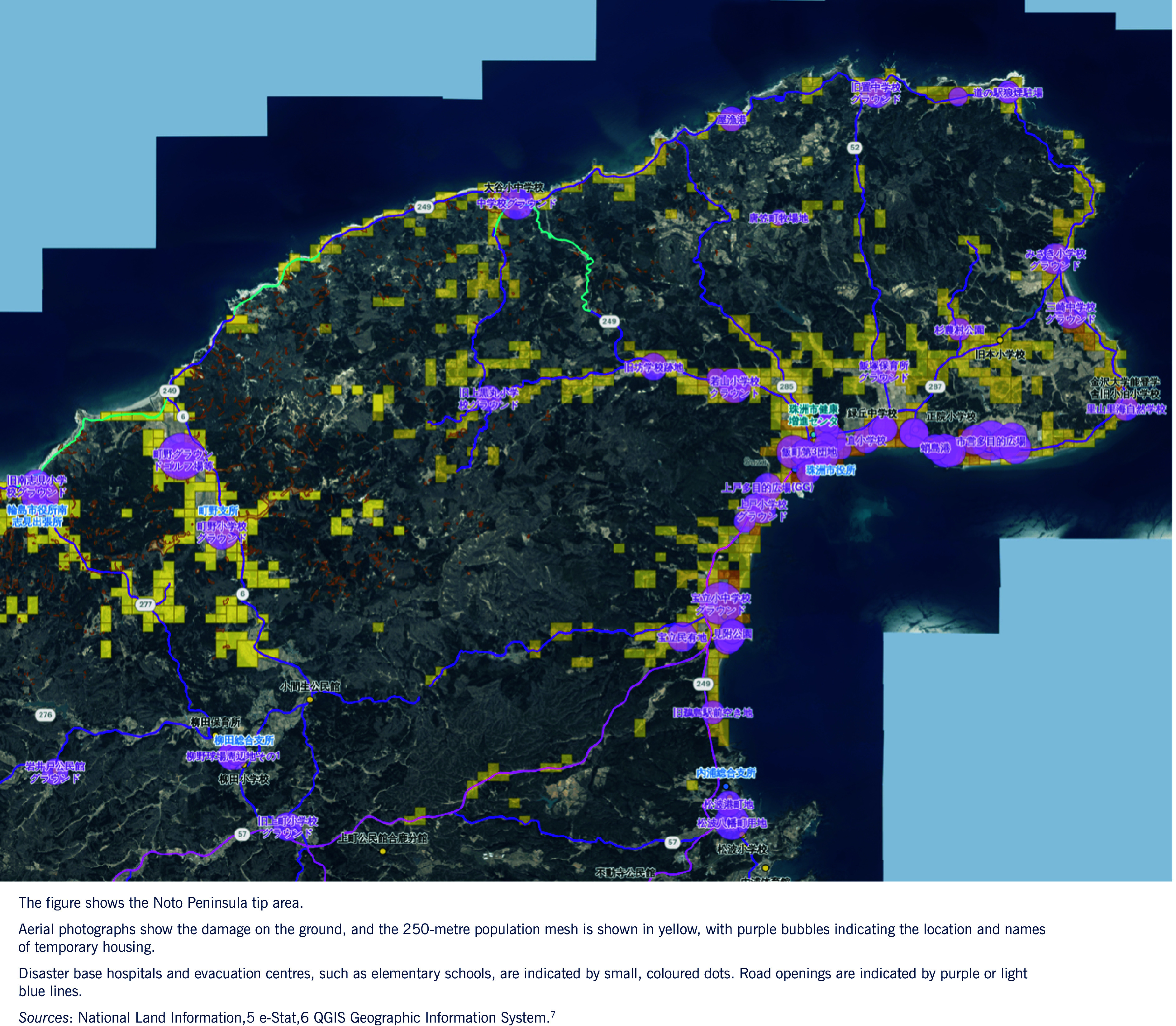 Fig. 1
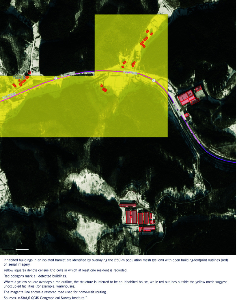 Fig. 2
| No. | Data publication period | Type of disaster | Data name | Source | URL |
|---|---|---|---|---|---|
| 1 | Post-disaster | Earthquake and torrential rain | Number of people in isolated settlements | Ishikawa Prefecture Disaster Response headquarters meeting materials |
|
| 2 | Post-disaster | Earthquake and torrential rain | Number of evacuees in shelters (Nanao City) | raokiey and Nanao City web site |
|
| 3 | Post-disaster | Earthquake and torrential rain | Number of emergency temporary housing | MASAMURA Akinobu, Tokyo Metropolitan University |
|
| 4 | Post-disaster | Earthquake | DHEAT, number of dispatched public health nurses | Ministry of Health, Labour and Welfare web site |
|
| 5 | Post-disaster | Earthquake and torrential rain | Landslide and deposition distribution | Geospatial Information Authority of Japan |
|
| 6 | Post-disaster | Earthquake | Tsunami inundation area | Geospatial Information Authority of Japan |
|
| 7 | Post-disaster | Earthquake and torrential rain | Inundation area by heavy rainfall | National Research Institute for Earth Science and Disaster Resilience |
|
| 8 | Post-disaster | Earthquake | Open building footprints | ||
| 9 | Post-disaster | Earthquake and torrential rain | Aerial photographs (orthoimages) | GSI tiles (Geospatial Information Authority of Japan) |
|
| 10 | Post-disaster | Earthquake and torrential rain | Emergency restored road sections | Ministry of Land, Infrastructure, Transport and Tourism road restoration visualization map | |
| 11 | Post-disaster | Earthquake and torrential rain | Damaged road locations | Ministry of Land, Infrastructure, Transport and Tourism road restoration visualization map | |
| 12 | Post-disaster | Earthquake | CS stereographic map | Forestry and Forest Products Research Institute, National Research and Development Agency |
|
| 13 | Post-disaster | Earthquake and torrential rain | 360° imagery | First author |
|
| 14 | Normal times | ND | Administrative districts | National Land Numerical Information, Japan |
|
| 15 | Normal times | ND | Peninsula circulatory roads | Digital National Land Information |
|
| 16 | Normal times | ND | Sediment disaster alert areas | Digital National Land Information |
|
| 17 | Normal times | ND | Tsunami inundation anticipation areas | Digital National Land Information |
|
| 18 | Normal times | ND | Schools | Digital National Land Information |
|
| 19 | Normal times | ND | Medical facilities | Digital National Land Information |
|
| 20 | Normal times | ND | Emergency transport roads | Digital National Land Information |
|
| 21 | Normal times | ND | National and prefectural agencies | Digital National Land Information |
|
| 22 | Normal times | ND | Municipal offices and public assembly facilities | Digital National Land Information |
|
| 23 | Normal times | ND | Population (250-m mesh) | The Portal Site of Official Statistics of Japan (e-Stat) | |
| 24 | Normal times | ND | Disaster base hospitals | Ishikawa Prefecture Open Data Catalogue |
|
| 25 | Normal times | ND | Public facilities | Ishikawa Prefecture Open Data Catalogue |
|
| 26 | Normal times | ND | Designated shelters | Ishikawa Prefecture Open Data Catalogue |
|
Peer Reviews
No public reviews on file for this paper yet. If you reviewed it on a platform where reviews are public (OpenReview, ICLR, NeurIPS, ICML), you can paste yours below so the community can read it here.
Videos
No videos yet. Explain this paper in a talk, walkthrough, or lecture? Add one.
Taxonomy
TopicsKnowledge Management and Technology · Earthquake and Disaster Impact Studies · Disaster Management and Resilience
On 1 January 2024, an earthquake of magnitude 7.6 struck the Noto Peninsula in Japan, causing over 500 deaths and damaging about 160 000 houses. (1) Eight months later, torrential rains in the same area caused a further 14 fatalities and extensive flooding. (2) During the first 4 months of the response, 15 489 people, including public health nurses (PHNs) and Disaster Health Emergency Assistance Teams, were dispatched to Ishikawa Prefecture. (3) Aggregated, real-time disaster data are available to support disaster response via the Shared Information Platform for Disaster Management and the Disaster Digital Information System for Health and Well-being, but they are rarely accessible to front-line personnel before their deployment to disaster-affected areas. (4) In early January 2024, we developed an open-data Public Health Nursing map (PHN-Map) on Web-based Geographic Information Systems (WebGIS) architecture, to support public health nursing activities by providing up-to-date situational information and training resources before deployment to the Noto Peninsula. This report describes the development of the WebGIS system and the subsequent addition of 360° images to PHN-Map in September 2024, as well as the results of a user survey.
Methods
Data integration
Between 2 and 7 January 2024, we downloaded data from National Land Numerical Information, a database of the Geospatial Information Authority of Japan. The extracted data included administrative areas, emergency transport roads, and medical and public facilities. (5) Additional data sets, namely 2020 census grid statistics (the 250-m population mesh from the Statistics Bureau via e-Stat portal (6)) and municipal open data on evacuees, isolated hamlets and temporary housing, were downloaded from public web sites (Table 1). Data sets were used to create thematic layers including administrative boundaries, emergency transport roads, medical facilities, shelters, evacuee counts, populations of isolated hamlets and temporary housing.
Several layers required trimming or reformatting before being added to the WebGIS platform and were edited in the Quantum Geographic Information System (QGIS). (7) To maximize speed of deployment, we used Felt, (8) a cloud-based collaborative mapping platform that connects spatial data sets and allows users to build interactive maps accessible from any device, including laptops used by PHNs in the field. The system also enables users to view their own location while exploring the map, facilitating situational awareness during disaster response. The use of WebGIS and the Felt software facilitated the integration of heterogeneous data sets into one platform, making it possible to visualize the distribution of evacuation centres, hazard areas and the population in a single image. The map was released publicly on 8 January 2024. After the torrential rains on 20–23 September 2024, inundation and landslide polygons plus new shelters were added; currently, 26 thematic layers are updated as needed.
360° imagery
In March 2024 and March 2025 (2 and 14 months post-quake, respectively), Insta360 X3 cameras recorded 360° photos at key sites in the Noto Peninsula. Images were published through an open-source viewer. (9) The URL for each photo was linked to its coordinates in PHN-Map pop-ups, enabling users to view the images in either a web browser or a head-mounted display, while 360° imagery provided spatial context beyond the 2D maps, enabling PHNs to virtually assess disaster conditions. Precautions included shooting when only a few people were present, avoiding non-researcher faces, and obscuring vehicle licence plates.
User feedback
With support from the National Association of Chief Public Health Nurses, an online questionnaire comprising three 10-point Likert-type questions was e-mailed to 5549 PHNs nationwide. The questionnaire was open from 11 April to 14 June 2024. It contained three questions:
How easy was PHN-Map to use?How useful was PHN-Map for your work during the Noto Peninsula earthquake?How necessary will PHN-Map be for future disaster PHN activities?
Respondents could also add free-text comments.
Results
Analytics recorded 301 visits on launch day (8 January 2024) and a weekday mean of 84 visits from 9 to 30 January 2024. After flood layers were added, visits peaked at 212 on 24 September 2024. Fig. 1 shows the PHN-Map of the Noto Peninsula that was made publicly available on 8 January 2024. The figure presents the version updated as of January 2025, incorporating additional data sets accumulated since the initial release. The map was generated from government aerial imagery and OpenStreetMap tiles and overlaid with symbols indicating damage status, shelters, PHN team bases, populated areas and temporary housing.
Public health nursing activity-support WebGIS (PHN-Map), as of January 2025
Reported field uses, derived from both web site analytics and survey comments, included:
pre-deployment triage: matching shelter density and road status to PHN specialties;flood-risk reassessment: overlapping flood polygons and earthquake damage zones to anticipate waterborne risks;home visit routing: identifying isolated households by intersecting population and building footprint data (Fig. 2); andtraining and debriefing: using 360° imagery to simulate field conditions for non-deployed PHNs.
The PHN-Map was created by the authors as a ready-made interactive WebGIS integrating multiple data layers; however, users could freely select which layers to display depending on their needs.
Home-visit routing
User survey
The questionnaire received 48 responses (response rate: 0.9%). (10) Survey results were: usability 5.5/10 (95% CI: 5.1–6.0), usefulness for earthquake response 5.5/10 (4.9–6.1) and need for future disasters 7.7/10 (7.2–8.3). PHNs who were inexperienced with GIS valued future need as highly as experienced peers. Free-text comments included requests for tutorials and lighter data formats.
Discussion
PHN-Map, constructed entirely from open data, reduced the “land-knowledge gap” among outside responders deployed to the Noto Peninsula earthquake, aligning with prior evidence that rapid GIS visualization can improve the efficiency of disaster resource allocation. (11) Integrating 360° media also provided an engaging educational tool for pre-service PHN students and disaster-naïve PHNs, who could virtually experience the affected area and rehearse response scenarios with high immersion. (9)
The main system development challenges included the need for manual geocoding of municipal PDF reports without coordinates; this work is labour-intensive, time-consuming and risks misplacing features. Large file sizes were also identified by both developers during implementation and users in survey responses, as a technical limitation that slowed transfers on low-bandwidth disaster networks and could exceed laptop capacity. Ongoing work includes developing automated PDF parsing and vector-tile conversion to address these issues. The survey’s very low response rate likely reflected fatigue among PHNs engaged in disaster response and the use of a broad mailing list, making invitations easy to overlook. This represents a limitation in the evaluation process rather than of the system itself. Further studies are needed to evaluate the system’s effectiveness in disaster exercises, assess PHN training needs, and explore the integration of real-time or crowd-sourced data.
Conclusion
An open-source WebGIS enriched with 360° imagery furnished PHNs with actionable, up-to-date information during a dual disaster of earthquake and floods. The system also addressed previous problems by enabling pre-deployment overview, the integration of multiagency data, and improved spatial understanding via 360° imagery, which also served as training material for non-deployed PHNs. Routine GIS use in everyday PHN work is recommended, as everyday use will increase PHNs’ and other responders’ proficiency with GIS tools when a disaster occurs.
The reference list from the paper itself. Each links out to its DOI / PubMed record.
- 1Damage caused by the 2024 Noto Peninsula earthquake and the response of fire departments, etc. Tokyo: Fire and Disaster Management Agency; 2024 (in Japanese). Available from: https://www.fdma.go.jp/disaster/info/items/ed 651f 44b 96482 e 107b 093fd 844f 4b 82796814 f 8.pdf, accessed 1 May 2025.
- 2Damage to the Noto Peninsula caused by the 2024 Oku-Noto heavy rain [website]. Kanazawa: Government of Ishikawa Prefecture; 2024 (in Japanese). Available from: https://www.pref.ishikawa.lg.jp/saigai/202409 ooame-higai.html, accessed 1 May 2025.
- 3Public health nurse deployment after the Noto Peninsula earthquake Tokyo: Ministry of Health, Labour and Welfare; 2024 (in Japanese). Available from: https://www.mhlw.go.jp/content/11907000/001282849.pdf, accessed 1 May 2025.
- 4Suzuki K. [Report on DMAT activities in the Noto Peninsula earthquake]. The 43rd Kanto-Koshinetsu Block Association of Physical Therapists and the 30th Chiba Prefecture Physical Therapy Academic Conference; 2024 (in Japanese). Available from: 10.14901/ptkanbloc.43.0_247_247, accessed 1 May 2025. · doi ↗
- 5National Land Numerical Information download service [website]. Tokyo: Ministry of Land, Infrastructure, Transport and Tourism; 2024 (in Japanese). Available from: https://nlftp.mlit.go.jp/ksj/, accessed 1 May 2025.
- 6E-Stat: portal site of official statistics of Japan [website]. Tokyo: The National Statistics Center; 2025. Available from: https://www.e-stat.go.jp/en, accessed 1 May 2025.
- 7QGIS Development Team. QGIS Geographic Information System. Available from: https://qgis.org/, accessed 1 May 2025.
- 8Felt. Collaborative mapping platform. Available from: https://felt.com/, accessed 1 May 2025.