Improved AIS data simplification algorithm for extracting typical routes considering motion continuity
Jin He, Jinjia Ruan, Yao Tong, Guojin Qin, Guojin Qin, Guojin Qin

TL;DR
This paper introduces an improved algorithm for simplifying AIS data to extract typical vessel routes while maintaining motion continuity, enhancing deep learning applications in maritime monitoring.
Contribution
The novel contribution is an enhanced distance threshold pruning technique that preserves vessel movement continuity in AIS data simplification.
Findings
Simplified data improves training efficiency and prediction accuracy in trajectory forecasting models.
Anomaly detection capabilities are enhanced with fewer false positives using the simplified data.
The method achieves faster convergence in deep learning models compared to using raw AIS data.
Abstract
Automatic Identification System (AIS) data provides crucial information about vessel trajectories. However, raw AIS data is often highly redundant, containing overlapping and repetitive routes, which complicates its direct use in maritime applications such as navigation planning and route prediction. In this paper, we propose an improved simplification algorithm designed to extract typical routes while preserving vessel movement continuity. Our approach simplifies complex AIS data by applying an enhanced distance threshold pruning technique and analyzing the continuity of vessel operations to address route segment discontinuities and coordinate deviations.We conducted experiments to evaluate the impact of the simplification algorithm on deep learning applications, specifically in trajectory prediction and anomaly detection. The results demonstrate that the simplified data significantly…
Genes, proteins, chemicals, diseases, species, mutations and cell lines named across the full text — each resolved to its canonical identifier and authoritative record.
Click any figure to enlarge with its caption.
 Figure 1
 Figure 2
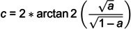 Figure 3
 Figure 4
 Figure 5
 Figure 6
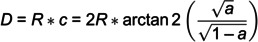 Figure 7
 Figure 8
 Figure 9
 Figure 10
 Figure 11
 Figure 12
 Figure 13
 Figure 14
 Figure 15
 Figure 16
 Figure 17
 Figure 18
 Figure 19
 Figure 20
 Figure 21
 Figure 22
 Figure 23
 Figure 24
 Figure 25
 Figure 26
 Figure 27
 Figure 28
 Figure 29
 Figure 30
 Figure 31
 Figure 32
 Figure 33
 Figure 34
 Figure 35
 Figure 36
 Figure 37
 Figure 38
 Figure 39
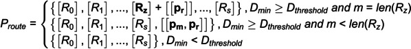 Figure 40
 Figure 41
 Figure 42
 Figure 43
 Figure 44
 Figure 45
 Figure 46
 Figure 47
 Figure 48
 Figure 49
 Figure 50
Peer Reviews
No public reviews on file for this paper yet. If you reviewed it on a platform where reviews are public (OpenReview, ICLR, NeurIPS, ICML), you can paste yours below so the community can read it here.
Videos
No videos yet. Explain this paper in a talk, walkthrough, or lecture? Add one.
Taxonomy
TopicsMaritime Navigation and Safety · Anomaly Detection Techniques and Applications · Historical Geography and Cartography