Post‐Release Survival and Behavioral Recovery of a Rehabilitated Short‐Finned Pilot Whale ( Globicephala macrorhynchus ) in the South China Sea Revealed Through Satellite Tracking
Mingming Liu, Mingli Lin, Agathe Serres, Mingyue Ouyang, Songhai Li

TL;DR
A rehabilitated short-finned pilot whale survived and adapted well after release into the South China Sea, showing normal behavior and movement patterns.
Contribution
First empirical evidence of successful rehabilitation and post-release survival of a short-finned pilot whale in the South China Sea.
Findings
Haitang survived beyond the critical six-week post-release benchmark.
His movement and diving behaviors were consistent with healthy wild individuals.
The Qiongdongnan slope was identified as a critical habitat for the species.
Abstract
Post‐release monitoring is critical for evaluating the success of rehabilitating stranded cetaceans, yet such data are scarce for many species in the South China Sea (SCS). We satellite‐tracked a rehabilitated subadult male short‐finned pilot whale ( Globicephala macrorhynchus ; named “Haitang”), following a live stranding on Hainan Island, China. We collected tracking locations and behavioral data over a 52‐day period and conducted a dedicated 3‐day expedition to resight Haitang at sea in the sixth week post‐release. Results confirm Haitang's survival beyond the critical 6‐week benchmark. Its daily movement distance (6.2–145.9 km) and speed (0.6–5.9 km/h) were consistent with those of healthy, free‐ranging conspecifics. Furthermore, diving behavior including time‐at‐depth budgets, maximum dive depth (621 m), diel patterns, and thermal‐depth profiles reflected natural foraging activity…
Genes, proteins, chemicals, diseases, species, mutations and cell lines named across the full text — each resolved to its canonical identifier and authoritative record.
Click any figure to enlarge with its caption.
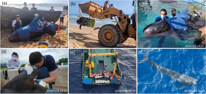 FIGURE 1
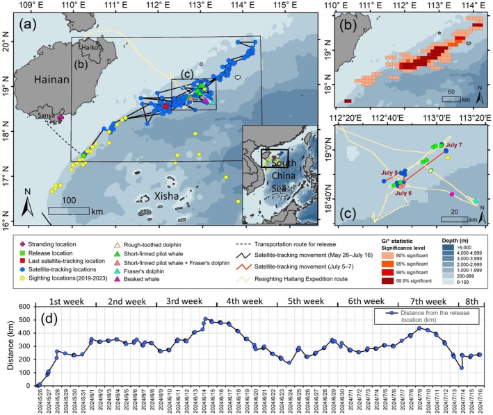 FIGURE 2
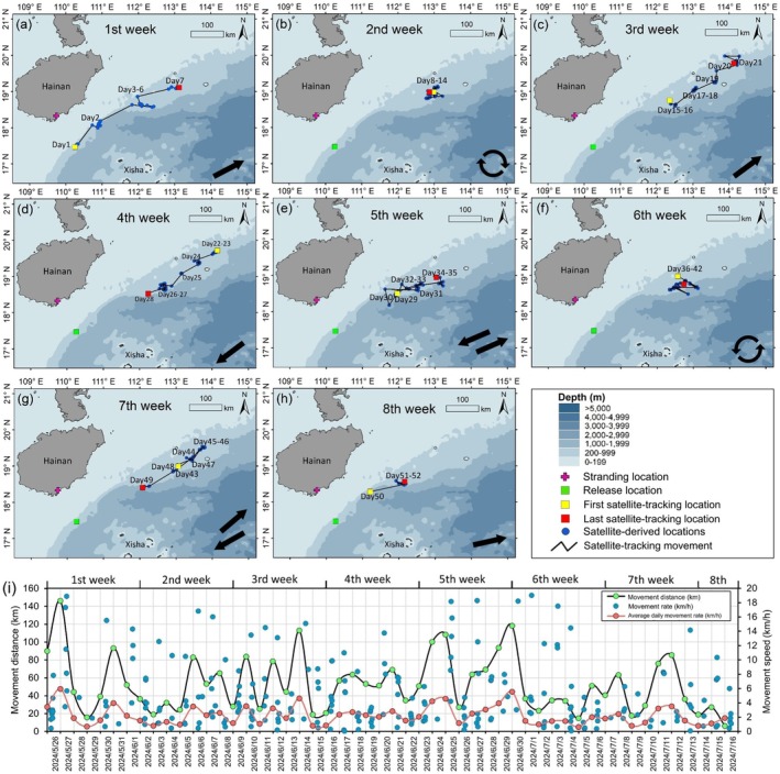 FIGURE 3
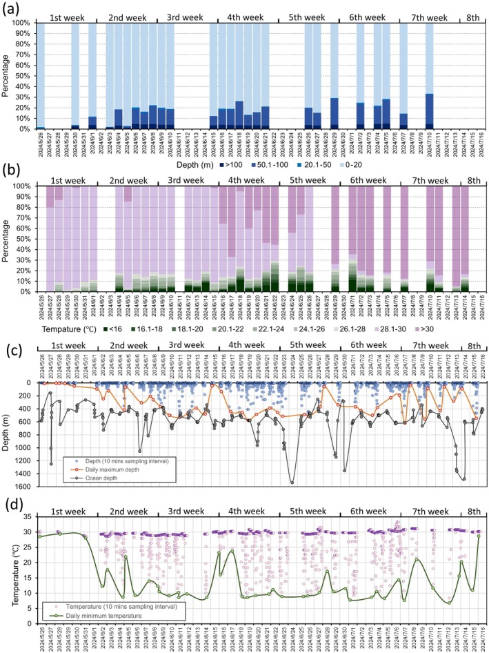 FIGURE 4
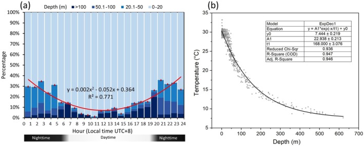 FIGURE 5
| Week post release | Period | No. of days | No. of qualified satellite‐tracking locations | Horizontal movement distance (km; Figure | Horizontal movement speed (km/h; Figure | Distance from first location to last (km; Figure | Distance from last location to release (km; Figure | Ocean depth (m, mean ± SD; Figure |
|---|---|---|---|---|---|---|---|---|
| 1st | May 26, 2024–June 1, 2024 | 7 | 37 | 480.0 | 2.8 | 353.8 | 354.0 | 513.7 ± 221.3 |
| 2nd | June 2, 2024–June 8, 2024 | 7 | 49 | 312.4 | 1.9 | 11.9 | 323.5 | 484.3 ± 119.4 |
| 3rd | June 9, 2024–June 15, 2024 | 7 | 49 | 391.1 | 2.3 | 219.4 | 482.6 | 550.2 ± 108.2 |
| 4th | June 16, 2024–June 22, 2024 | 7 | 54 | 349.4 | 2.1 | 241.3 | 240.6 | 570.9 ± 131.2 |
| 5th | June 23, 2024–June 29, 2024 | 7 | 49 | 512.6 | 3.1 | 124.5 | 336.9 | 647.1 ± 287.5 |
| 6th | June 30, 2024–July 6, 2024 | 7 | 46 | 312.8 | 1.9 | 29.6 | 298.8 | 627.6 ± 264.7 |
| 7th | July 7, 2024–July 13, 2024 | 7 | 31 | 347.3 | 2.1 | 124.2 | 219.3 | 634.0 ± 271.2 |
| 8th | July 14, 2024–July 16, 2024 | 3 | 20 | 52.0 | 1.0 | 104.7 | 235.7 | 621.9 ± 229.7 |
| Total | May 26, 2024–July 16, 2024 | 52 | 335 | 2757.6 | 2.2 | 104.7 | 235.7 | 576.7 ± 216.3 |
| Date | Encounter time (UTC + 8) | Species | Distance to nearest satellite‐tracking location (km) | Water depth (m) | Number of high‐quality photographs | Duration of drone videos (mins) |
|---|---|---|---|---|---|---|
| 2024/7/5 | 13:28–14:49 | GM (10–30) | 17.7 | 522 | 3385 | 33.4 |
| 2024/7/5 | 14:51–15:27 | GM (10–20) | 14.3 | 454 | 131 | 4.9 |
| 2024/7/5 | 16:01–16:15 | SB (20–40) | 18.1 | 708 | 384 | 10.9 |
| 2024/7/5 | 16:29–16:48 | GM (~100) | 18.8 | 684 | 555 | 5.0 |
| 2024/7/6 | 05:30–06:05 | LH (> 100) | 53.8 | 1380 | 716 | 9.2 |
| 2024/7/6 | 08:26–08:29 | ZP (1) | 35.3 | 1258 | 0 | 0 |
| 2024/7/6 | 10:48–11:31 | GM (~50) + LH (100–200) | 2.0 | 663 | 2404 | 21.2 |
| 2024/7/6 | 11:33–12:51 | GM (~20) | 2.7 | 604 | 1097 | 3.9 |
| 2024/7/6 | 13:00–13:37 | GM (40–50) | 2.3 | 589 | 854 | 25.4 |
| 2024/7/6 | 15:19–18:18 | GM (~50) + LH (~100) | 1.8 | 640 | 690 | 17.1 |
| 2024/7/7 | 12:35–12:50 | GM (~20) | 0.2 | 463 | 428 | 8.2 |
| 2024/7/7 | 12:56–13:06 | GM (10–20) | 6.2 | 467 | 383 | 3.8 |
| 2024/7/7 | 13:26–15:55 | GM (> 30) | 4.3 | 502 | 1464 | 21.4 |
- —National Natural Science Foundation of China10.13039/501100001809
- —Science and Technology Talent Innovation Project of Hainan
- —Hainan Provincial Natural Science Foundation of China
Peer Reviews
No public reviews on file for this paper yet. If you reviewed it on a platform where reviews are public (OpenReview, ICLR, NeurIPS, ICML), you can paste yours below so the community can read it here.
Videos
No videos yet. Explain this paper in a talk, walkthrough, or lecture? Add one.
Taxonomy
TopicsMarine animal studies overview · Ichthyology and Marine Biology · Marine and fisheries research
Introduction
1
The short‐finned pilot whale ( Globicephala macrorhynchus ) is a deep‐diving, highly social delphinid with a global distribution in tropical to warm temperate waters, where it shows a strong preference for continental slopes, shelf edges, and oceanic islands (García‐Aguilar et al. 2021; Jefferson et al. 2015; Olson 2018). This species is notably prone to stranding, especially in mass events, as frequently reported in many tropical‐subtropical regions like Australia (Groom and Coughran 2012), Indonesia (Mustika et al. 2022), Florida, USA (Moore et al. 2020; Wells, Fougeres, et al. 2013), and the Philippines (Aragones et al. 2024). In the South China Sea (SCS, western Pacific), the short‐finned pilot whale is relatively common, comprising approximately 10% of cetacean encounters in northern SCS surveys, and these groups typically comprised abundant individuals (mean ± SD: 45.3 ± 41.7; Lin et al. 2021; Liu, Lin, Lin, Dong, and Li 2024; Liu, Lin, Lin, Dong, Liu, et al. 2024). Furthermore, strandings of this species were regularly documented along the coasts in the SCS, particularly in the northern and western areas (Chou et al. 2024; Liu et al. 2019, 2022; Liu, Lin, Lin, Dong, and Li 2024; McGowen et al. 2021). Despite the species' prevalence in the region, no post‐release monitoring of rehabilitated individuals has been conducted in the SCS, creating a critical gap in evaluating the success of conservation interventions and the understanding of species' regional movement ecology.
Recent advances in biologging have enabled detailed behavioral and ecological studies of rehabilitated cetaceans after live strandings, transforming satellite tagging from a simple tracking tool into a critical method for validating survival and assessing long‐term outcomes (Moore et al. 2007; Sampson et al. 2012; Wells, Fauquier, et al. 2013; Zagzebski et al. 2006). Satellite‐tracking studies can not only provide definitive evidence of post‐release survival—a critical metric for conservation efforts—but also yield insights into movement ecology and behavioral patterns that are otherwise unattainable (Dunn et al. 2020; Pulis et al. 2018; Scott et al. 2001). For example, satellite tracking of rehabilitated odontocetes—spanning species such as pilot whales (Globicephala spp.; Moore et al. 2020; Wells, Fougeres, et al. 2013), bottlenose dolphins (Tursiops spp.; Balmer et al. 2010; Wells et al. 1999), and harbor porpoises ( Phocoena phocoena ; Schofield et al. 2008; Westgate et al. 1998)—has documented successful long‐term post‐release survival, re‐integration into natural habitats, and in some cases, remarkable long‐distance movements.
Crucially, satellite‐tracking studies of rehabilitated pilot whales can offer particularly instructive insights, revealing key adaptive behaviors and physiological benchmarks. For example, several studies have demonstrated not only survival but also the recovery of deep‐diving capacity—a vital indicator of physiological health—and the strategic use of ocean currents for efficient travel (Gales et al. 2012; Mate et al. 2005; Moore et al. 2020). These findings establish an interpretive framework in which normal movement and dive profiles serve as strong proxies for successful rehabilitation (Nawojchik et al. 2003; Wells, Fougeres, et al. 2013). However, the application of this framework remains geographically limited—most satellite‐tracking studies of rehabilitated pilot whales have occurred in the Atlantic and Oceanian basins. Consequently, little is known about the post‐release ecology of this species in the distinct oceanographic context of the western Pacific.
Our study addresses this gap directly. We deployed a satellite tag on a rehabilitated subadult male short‐finned pilot whale stranded on Hainan Island, China, applying the established monitoring framework to a novel regional context in the SCS. Our primary objectives were to: (1) evaluate the post‐release survival success of the tracked pilot whale, and (2) characterize its post‐release movement and diving behavior.
Methods
2
Stranding, Rescue, and Rehabilitation
2.1
On the early morning of January 3, 2024, a live short‐finned pilot whale stranded on Haitang Bay beach in Sanya, China (Figures 1a and 2a). This individual, subsequently named “Haitang”, was handled by a rescue team from the Hainan Cetacean Stranding Response Network at approximately 09:30 (local time zone: UTC + 8; all times hereafter in UTC + 8 unless noted). By 14:00, the team had transported “Haitang” to Sanya Haichang Fantasy Town (Figure 1b,c). Two experienced veterinarians identified Haitang as a subadult male, measuring 3.6 m in length and weighing approximately 500 kg. Due to its difficulty maintaining natural buoyancy, Haitang was placed in a small circular pool (radius: ~3 m) for medical treatment and provided with supportive flotation devices (Figure 1c; Geraci and Lounsbury 2005).
Key events of the short‐finned pilot whale ( Globicephala macrorhynchus ; male subadult, 3.6 m long) named “Haitang” recorded on Hainan Island, China in 2024: (a) stranding, (b) transportation, (c) rehabilitation, (d) satellite‐tagging and (e, f) release to wild. Photos by the Hainan Daily and the Sanya Blue Ribbon Ocean Conservation Association.
(a) Haitang's satellite‐tracking locations (blue dots) and horizontal movement routes (black lines) over 52 tracking days from May 26, 2024 (release to wild) to July 16, 2024 (tag's satellite messages stopped transmitting). Yellow dots indicate encounter locations of short‐finned pilot whales previously recorded from cetacean‐dedicated surveys between 2019 and 2023 (Liu, Lin, Lin, Dong, and Li 2024; Liu, Lin, Lin, Dong, Liu, et al. 2024). (b) Hotspot areas of all satellite‐tracking locations based on Gi hotspot analysis. (c) Survey routes (yellow lines) and encounter locations (triangle symbols) of various cetacean species recorded during the Resighting Haitang Expedition conducted between July 5–7, 2024, shown together with Haitang's satellite‐tracking locations acquired during July 5–7, 2024. (d) Distance (km) measured from each satellite‐tracking location to the initial release location.*
On January 21, 2024, Haitang was transferred to a larger outdoor aquarium pond (approximately 30 m × 50 m × 3 m in length × width × depth) for rehabilitation. The period of rehabilitation lasted approximately 4 months. On May 7, 2024, a comprehensive pre‐release health assessment was conducted by an 11‐member panel composed of five veterinarians, two researchers, two NGO staff, and two government officers. Haitang's health was evaluated based on physical condition (e.g., body mass/length, presence of scars, wounds, or bruising), food intake records, clinical diagnostics (e.g., gastroscopy, ultrasonography, and hematology), and behavioral monitoring (e.g., breathing interval, swimming posture, balance, and directional control) (Dierauf and Gulland 2001; Sampson et al. 2012; Zagzebski et al. 2006). Considering all these factors, the evaluation panel concluded that Haitang met all releasable criteria including completely healed surface injuries, normal ratio of body mass and length, sufficient food intake and good appetite (10–15 kg squid and/or herring daily), clinical parameters within typical ranges, and no abnormal behavior.
Satellite‐Tagging and Release
2.2
Following established protocols (Gales et al. 2012; Moore et al. 2020; Wells, Fougeres, et al. 2013), we deployed a dorsal fin‐mounted satellite tag (SPLASH10‐268D, Wildlife Computers, Redmond, WA, USA) on Haitang. The tag weighed 89 g in air and measured 212 × 21 × 31 mm (length × width × height). After applying topical anesthesia to the attachment site, two 8‐mm‐diameter holes were drilled through the dorsal fin using a sterilized stainless steel coring tool, positioned approximately 30 mm and 60 mm from the posterior trailing edge (Figure 1d). The tag was secured using a slow‐degrading cable tie threaded through these holes. The entire procedure was completed within 15 min on May 25, 2024, 1 day before release, with care taken to minimize Haitang's struggling behavior and stress response.
Haitang was placed in a custom‐fitted stretcher and open container filled with recirculating seawater, hoisted aboard the research vessel “LIYANG 358” (500 gross tons), and transported offshore under the supervision of the Hainan Cetacean Stranding Response Network (Figure 1e). After a 16‐h transit (including 6‐h on truck and 10‐h aboard vessel), Haitang was released at 06:18 on May 26, 2024, at a predetermined site southeast of Sanya. The release location was selected as the nearest deep‐water habitat (water depth: around 500 m; distance: approximately 70 nm from the Sanya Bay Port and 60 nm from Hainan Island; Figure 2a) known to be used by short‐finned pilot whales in the region (Lin et al. 2021; Liu, Lin, Lin, Dong, and Li 2024; Liu, Lin, Lin, Dong, Liu, et al. 2024; Liu et al. 2026). This location minimized transportation time from land while maximizing the opportunity for Haitang to re‐integrate into natural habitats and locate conspecific groups. Post‐release vessel‐based monitoring continued until 07:30 to assess its initial survival and behavior in open water (Figure 1f).
Tag Configuration
2.3
The Splash10‐268D tag included three sensors for pressure, wet/dry status, and external temperature, along with an Argos satellite transmitter. To support long‐term monitoring, the tag's histogram sampling function for depth and ambient temperature was set to 60‐s intervals (Nawojchik et al. 2003; Wells et al. 2009). Data were aggregated into the following bins for time‐at‐depth (TAD) and time‐at‐temperature (TAT) analyses: (1) depth categories (unit: m): < 20, 20.1–50, 50.1–100, > 100; (2) temperature categories (unit: °C): < 16, 16.1–18, 18.1–20, 20.1–22, 22.1–24, 24.1–26, 26.1–28, 28.1–30, > 30. Depth bins were defined based on known dive ranges for Globicephala spp. (Adamczak et al. 2021; Alves et al. 2013; Shearer et al. 2022), while temperature bins reflected summertime depth‐dependent thermal gradients in the northern SCS (He et al. 2022; Huang et al. 2008).
The tag was programmed to transmit 250 times daily, balancing data acquisition and battery longevity (expected lifespan: 90–100 days; Moore et al. 2020; Wells et al. 2009). After an initial 24‐h continuous transmission period, Argos satellite positioning and data transmission were scheduled from 03:00–11:00 to 15:00–23:00 local time to coincide with satellite coverage (Dunn et al. 2020; Pulis et al. 2018; Wells et al. 2009). Satellite‐tracking locations were prioritized over depth/temperature data to ensure daily movement monitoring (Moore et al. 2020; Wells, Fougeres, et al. 2013). All other data collection features were disabled to conserve battery.
Post‐Release Monitoring Expedition
2.4
A dedicated at‐sea expedition (hereafter referred to as “Resighting Haitang Expedition”) was conducted from July 5 to 7, 2024, following over 5.5 weeks of stable satellite tracking, which represents a key time point for assessing long‐term survival possibility (Wells, Fauquier, et al. 2013). The primary goal was to find Haitang and assess its post‐release survival. Guided by recent tag locations, we implemented standard visual survey methods to search for short‐finned pilot whales and other cetaceans in the target area (Figure 2a). Observers used a reference image of Haitang's tagged dorsal fin (Figure 1d) to aid at‐sea identification. During the expedition, high‐quality photos and videos were taken using Canon 7D Mark II cameras and DJI Mavic Pro drones once cetaceans were encountered (Liu, Lin, Lin, Dong, Liu, et al. 2024; Liu et al. 2026). All records were later reviewed by two experienced researchers to confirm whether Haitang was present.
Data Processing and Analyses
2.5
All original satellite messages were archived until transmissions ceased. Data were processed via Argos CLS Services (www.argos‐system.org) and the Wildlife Computers Data Portal (https://wildlifecomputers.com/). Locations from standard Argos quality classes (3, 2, 1), with estimated error radii of ≤ 250 m, 250–500 m, and 500–1500 m, respectively, were retained (Hays et al. 2001; Liu et al. 2021). Auxiliary classes (0, Z, A, B) within 5 km of a high‐quality fix were also kept based on spatial redundancy (Mate et al. 2005; Wells et al. 2009). The Douglas Argos Filter assessed location plausibility using movement speed, distance, turning angle, and location quality (Douglas et al. 2012). Locations were retained only if the derived movement speed did not exceed 20 km/h, consistent with typical horizontal swimming speeds for Globicephala spp. (e.g., Bloch et al. 2003; Gales et al. 2012; Moore et al. 2020; Wells, Fougeres, et al. 2013).
Based on filtered satellite‐tracking locations, hotspot areas for Haitang were identified using Gi* hotspot analysis in ArcGIS 10.1 (Liu et al. 2022), with a search radius of 5 km. The 52‐day satellite‐tracking period was divided into eight consecutive weeks including seven full weeks plus a three‐day eighth week. Haitang's weekly movement routes were reconstructed by connecting time‐series locations within each week. Its horizontal movement distance (km) and speed (km/h) were calculated using consecutive filtered locations ≥ 30 min apart (Pulis et al. 2018; Schofield et al. 2008). Positions apart < 30 min were excluded to avoid Argos positioning inaccuracies. Straight‐line distances (km) from each satellite‐tracking location to the release, and from the first satellite‐tracking location to the last per week, were measured using “Proximity” and “Point Distance” tools in ArcGIS.
Raw depth and temperature data were decoded from Argos satellite messages using Igor Pro 9.05 (WaveMetrics, Lake Oswego, OR, USA). Stacked bar charts illustrated TAD and TAT profiles over 26 and 37 days of successful recording, respectively. Time‐series of depth and temperature measurements (10‐min intervals) were plotted over 47 and 43 tracking days. Bathymetric values at each satellite‐tracking location were extracted from the ETOPO Global Relief Model (NOAA) and overlaid with depth time‐series data to contextualize environmental variation.
To examine diel deep‐diving patterns, a 24‐h histogram (UTC + 8) was constructed showing the percentage of time spent within predefined depth layers (< 20, 20.1–50, 50.1–100, > 100; unit: m). Sunrise and sunset times for the study area (Sanya, Hainan) were obtained from an online database (https://www.timeanddate.com/), with daytime and nighttime durations averaged across all 52 tracking days (Dunn et al. 2020; Moore et al. 2020). Using OriginPro 2024 (OriginLab, Northampton, MA, USA), concurrent depth (X‐axis) and temperature (Y‐axis) records were plotted and fitted with a regression curve to explore their relationship.
Results
3
Satellite Tracking Profile
3.1
The first satellite transmission arrived 7 min post‐release, with the initial qualified location recorded approximately 350 m from the release location (Figure 2a). The tag transmitted continuously until July 16, 2024, spanning 52 tracking days. At least one qualified satellite‐tracking location was obtained daily (range: 1–12), yielding 335 qualified locations (mean: 6.4 per day and 41.8 per week). Of these locations, 120 were standard quality (3, 2, 1) and 215 were auxiliary (0, Z, A, B).
Movement Patterns
3.2
Over the 52‐day satellite‐tracking period, Haitang traveled a minimum cumulative distance of 2757.6 km, based on all 335 filtered locations (Table 1 and Figure 2a). Gi* hotspot analysis revealed its concentrated presence along the Qiongdongnan continental slope off Hainan Island, mainly within the 200–999 m depth zone (Figure 2b). After release, Haitang moved northeast in the 1st week (Figure 3a), stayed in a small area within a radius of approximately 15 km in the 2nd week (Table 1 and Figure 3b), and resumed northeast movement in the 3rd week (Figure 3c). It reversed to the southwest in the 4th week (Figure 3d), showed oscillatory movement in the 5th week (Figure 3e), and restricted movement to a radius of approximately 30 km in the 6th week, overlapping spatially with the 2nd week's range (Table 1 and Figure 3f). It resumed variable directional movement in the 7th and 8th weeks (Figure 3g,h).
TABLE 1: Summary of movement characteristics calculated using satellite‐tracking data acquired from “Haitang”, a live‐stranded and rehabilitated short‐finned pilot whale ( Globicephala macrorhynchus ) during its 52 post‐release tracking days in the South China Sea. Ocean depth (m) measured at each satellite‐tracking location from a bathymetric layer of the ETOPO Global Relief Model.
Satellite‐tracking‐ locations (blue dots) and movement routes (black lines) of Haitang in the (a) first, (b) second, (c) third, (d) fourth, (e) fifth, (f) sixth, (g) seventh, and (h) eighth week post‐release. Predominant movement orientation of Haitang marked at the right bottom corner in each panel. (i) Movement distance (km) and speed (km/h) of Haitang in 52 tracking days from May 26 to July 16, 2024.
The mean distance from the 335 filtered satellite‐tracking locations to the release location was 297.0 ± 99.5 km (mean ± SD; Figure 2a,d). The farthest point (506.9 km from release) was recorded on June 14, 2024 (Day 21; Figures 2d and 3c). The last satellite‐tracking location on July 16, 2024 (Day 52) was 235.7 km from release (Figures 2d and 3h). Daily movement distances ranged from 6.2 to 145.9 km (mean ± SD: 53.0 ± 31.3 km; Figure 3i). The highest weekly cumulative movement distance (512.6 km) was observed in the 5th week (Table 1 and Figure 3e). Daily movement distances exceeded 100 km on only 5 days (Day 2, 20, 30, 31, and 36; Figure 3i). The overall movement speed was 2.2 km/h (i.e., 52.8 km/day). Acceptable movement speed (≤ 20 km/h) varied from 0.1 to 18.9 km/h, with daily averages between 0.6 and 5.9 km/h (Figure 3i).
Resighting Haitang Expedition
3.3
The Resighting Haitang Expedition (July 5–7, 2024) included three survey days with 13 cetacean encounters: eight short‐finned pilot whale groups, two mixed‐species groups of pilot whales and Fraser's dolphins ( Lagenodelphis hosei ), one Fraser's dolphin group, one rough‐toothed dolphin ( Steno bredanensis ) group, and one unidentified beaked whale (Ziphiidae) (Table 2 and Figure 2c). Short‐finned pilot whale group sizes ranged from 10–20 to approximately 100 individuals, with encounter location depths averaging 558.5 ± 83.2 m (mean ± SD, n = 10; Table 2). The 10 pilot whale encounters occurred 0.5–18.8 km from Haitang's nearest satellite‐tracking locations (Table 2 and Figure 2c), with distance of only 0.2–6.2 km on July 6–7, 2024 (Table 2). Despite this close proximity of these groups to Haitang's transmitted locations and the collection of 12,491 high‐quality photographs and 164.4 min of drone videos, we did not confirm Haitang's presence among any individuals. This was likely due to the large group sizes and the challenge posed by satellite transmission‐reception delays in pinpointing the individual's real‐time location.
Depth and Temperature Variability
3.4
TAD and TAT analyses indicated Haitang primarily occupied the upper 20 m of the water column (Figure 4a) and temperatures ≥ 28.1°C (Figure 4b). Time spent at depths > 20 m and temperatures < 28°C was limited (daily proportion < 10%) initially, but increased and stabilized at 10%–30% in subsequent weeks (Figure 4a,b). The TAD daily proportion in depths greater than 20 m rose from 1.8% (May 26) to 33.2% (July 10; Figure 4a), while the TAT proportion in temperatures lower than 28°C increased from 0% (May 27) to a peak of 30.8% (July 2; Figure 4b).
Satellite‐tracking profiles of Haitang in 52 post‐release days from May 26 to July 16, 2024: (a) TAD (time at depth) and (b) TAT (time at temperature) data summaries, and time‐series (c) depth and (d) temperature measurements. TAD and TAT data summaries indicated proportion of duration Haitang stayed at four depth ranges (unit: M): 0–20, 20.1–50, 50.1–100, and > 100, and at nine temperature ranges (unit: °C): < 16, 16.1–18, 18.1–20, 20.1–22, 22.1–24, 24.1–26, 26.1–28, 28.1–30, and > 30, respectively. Time‐series data were collected for depth (blue dots) and temperature (purple dots) measurements with 10‐min sampling intervals. Daily maximum depth shown by orange circles and daily minimum temperature by green circles. Ocean depth (gray dots) measured at each satellite‐tracking location from a bathymetric layer of the ETOPO Global Relief Model and weekly summarized in Table 1.
Weekly maximum dive depths were 95.3 m (1st week), 418.8 m (2nd week), 531.0 m (3rd week), 575.8 m (4th week), 515.8 m (5th week), 500.8 m (6th week), 621.0 m (7th week), and 545.5 m (8th week), maintaining around 500 m since the 2nd week (Figure 4c). Ocean depths at the 335 filtered satellite‐tracking locations ranged from 157 to 1539 m (mean ± SD: 576.7 ± 216.3 m), showing a weak increase with time (Table 1; Figure 4c). Minimum weekly temperatures were 28.0°C (1st week), 8.7°C (2nd week), 8.6°C (3rd week), 8.6°C (4th week), 8.9°C (5th week), 7.8°C (6th week), 6.8°C (7th week), and 11.0°C (8th week) (Figure 4d).
Diel depth patterns showed Haitang spent 1.4%–15.4% of daytime (05:00–19:00) at depths > 20 m, increasing to approximately 30% at night (19:00–05:00; Figure 5a). The TAD proportion for depths > 20 m was fitted with a quadratic function (y=0.002x2−0.052x+0.364;R2=0.771; Figure 5a). A strong exponential relationship (y=A1*exp−xt1+y0;R2COD=0.947) was observed between concurrent depth and temperature records (n = 2411; Figure 5b).
(a) Diel pattern of TAD (time at depth) data shown by the percentage of time spent within predefined depth layers (< 20, 20.1–50, 50.1–100, > 100; unit: M) using a 24‐h histogram (UTC + 8) across 52 tracking days. (b) Regression of concurrent depth (X‐axis) and temperature (Y‐axis) records fitted with an exponential curve.
Discussion
4
Survival Success
4.1
First, Haitang's 52‐day post‐release satellite‐tracking period supports a successful survival outcome. Based on an evaluation of 69 cases across 10 odontocete species, Wells, Fauquier, et al. (2013) proposed a benchmark of at least 6 weeks post‐release survival for rehabilitated cetaceans, as individuals surviving beyond this period demonstrate a high probability of long‐term survival. With a tracking duration of 52 days (i.e., 7.5 weeks), Haitang meets this criterion, indicating a positive rehabilitation achievement. Tracking duration serves as one indicator of post‐release success, though it is influenced by tag performance, attachment integrity, and the individual's health status (Andrews et al. 2019; Moore et al. 2020; Wells, Fougeres, et al. 2013). The 52‐day period was substantially shorter than the tag's expected battery life (i.e., 90–100 days). A status report received 8 days before transmissions ceased indicated sufficient battery capacity, with only approximately 14,000 of an expected 25,000 transmissions completed. Therefore, battery exhaustion is unlikely to have caused transmission termination, which was more likely due to preprogrammed tag detachment.
Second, the recovery of species‐typical movement and diving behaviors further substantiates Haitang's long‐term survival prospects. During the first week, Haitang's movement was directionally consistent toward the northeast with very scarce dives exceeding 100 m, a pattern potentially indicative of broad‐scale searching behavior for conspecifics or familiar habitats (Schofield et al. 2008; Moore et al. 2020). After the first week, movement became more variable, time spent at depths > 20 m increased to 10%–30%, and daily maximum dive depths regularly reached > 200 m. Together, these behavioral shifts, including a diel pattern of increased deep‐diving at night, align closely with known species‐specific ecology (Aguilar Soto et al. 2008; Alves et al. 2013; Quick et al. 2017), supporting the conclusion that Haitang successfully adapted to post‐release life in its natural habitat.
Third, findings from the Resighting Haitang Expedition provided supplementary evidence confirming Haitang's survival into the sixth week post‐release. During the expedition, 13 cetacean groups were encountered, 10 of which consisted of short‐finned pilot whales totaling several hundred individuals. This high local abundance suggests favorable conditions for long‐term survival, given the social and foraging benefits of group integration (Hill et al. 2019; Mahaffy et al. 2015; Wells, Fougeres, et al. 2013). Over the three‐day expedition, Haitang's movements were confined to an area with a radius of approximately 30 km, with the nearest conspecific groups located only a few kilometers from Haitang's satellite‐tracking positions. This spatial proximity further suggests that Haitang was well‐positioned to integrate into a free‐ranging conspecific group, although direct photographic confirmation was not obtained.
Movement, Distribution, and Habitat
4.2
The combination of Haitang's satellite‐tracking routes and identified hotspot areas with data from the Resighting Haitang Expedition extends the known distribution range of short‐finned pilot whales in the waters nearby Hainan Island, which have not been fully investigated during boat‐based surveys (Lin et al. 2021; Liu, Lin, Lin, Dong, and Li 2024; Liu, Lin, Lin, Dong, Liu, et al. 2024). Although released within a previously recognized hotspot based on 23 ship‐based encounters (Figure 2a), Haitang did not stay near the release location. Instead, it rapidly departed the area and exhibited a combination of directional travel, temporary residency, and highly variable movement. The overall average movement speed (i.e., 2.2 km/h) and average daily speed (0.6–5.9 km/h) align with published values for the species: 0.2–14.5 km/h (Bloch et al. 2003), 2–7 km/h (Wells, Fougeres, et al. 2013), 3.4 km/h (0.03–9.98; García‐Aguilar et al. 2021), 3.4 km/h (0.03–9.98; García‐Aguilar et al. 2021), 4.4 km/h (Moore et al. 2020), and 6 km/h (Gales et al. 2012). Although conservative, these movement estimates collectively indicate Haitang's healthy locomotor performance after its release.
Haitang's habitat use was consistent with the species' known preference for continental slope environments (Kendall‐Bar et al. 2016; Moore et al. 2020; Thorne et al. 2017). Mean water depths derived from 335 qualified satellite‐tracking locations (576.7 ± 216.3 m) and those recorded during the Resighting Haitang Expedition (558.5 ± 83.2 m; n = 10) closely matched previously reported bathymetric ranges in the region (e.g., 462.8 ± 140.4 m to 1025.5 ± 655.4 m; Liu, Lin, Lin, Dong, and Li 2024). These results indicate that the area frequented by Haitang represents a recurrent and significant habitat for the species. Combined with recent survey data (Liu, Lin, Lin, Dong, and Li 2024; Liu, Lin, Lin, Dong, Liu, et al. 2024), this study identifies the Qiongdongnan slope as a critical habitat for short‐finned pilot whales in the northern SCS.
Deep‐Diving Behavior
4.3
TAD analysis revealed that during the first week post‐release, Haitang spent > 90% of its time in the upper 20 m of the water column and performed few deep dives. A progressive recovery of deep‐diving behavior was observed in subsequent weeks, reflected by increased time at depths greater than 20 m, greater maximum dive depths, and lower minimum temperatures. From the second week onward, daily time budgets spent at depths > 20 m stabilized between 10% and 30%, with a slight increasing trend over time. These patterns are consistent with rehabilitated conspecifics, which spend roughly 80%–90% of their time near the sea surface (Mate et al. 2005; Wells, Fauquier, et al. 2013), and align with natural behavior in free‐ranging individuals: approximately 75%–85% of time in the upper 20‐m layers (Alves et al. 2013; Heide‐Jørgensen et al. 2002; Quick et al. 2017). Notably, Haitang's gradually increased maximum recorded dive depth (418.8–621.0 m) since the second post‐release week falls within the known range recorded from healthy, free‐ranging conspecifics including 540–1018 m (Aguilar Soto et al. 2008), 130–988 m (Alves et al. 2013), 600–828 m (Heide‐Jørgensen et al. 2002), 621.4 ± 225.8 m (max: 864 m; Gough et al. 2025), and 444 ± 85 (max: 617 m; Aoki et al. 2017), confirming the restoration of its deep‐diving capacity.
Time‐budget analyses also revealed a clear diel pattern: Haitang spent approximately twice as much time at depths > 20 m during nighttime compared to daytime. This finding is consistent with previously reported nocturnal diving behavior in pilot whales (Moore et al. 2020; Nawojchik et al. 2003; Wells, Fougeres, et al. 2013). This pattern aligns with the hypothesis that deep‐diving odontocetes are more active at night, likely in association with foraging on vertically migrating prey (Alves et al. 2013; Quick et al. 2017; Shearer et al. 2022). Specifically, pilot whales may perform shallower, non‐feeding dives during the day when the deep scattering layer is at greater depths, and deeper dives at night to access prey as the layer ascends (Baird et al. 2002; Gough et al. 2025; Heide‐Jørgensen et al. 2002).
By using Haitang as a mobile sampling platform, vertical movement data revealed temperature variations along the bathymetric gradient (i.e., 0–600 m) in the Qiongdongnan slope area during summer, showing a strong exponential relationship. This result is highly consistent with in situ measurements and physical oceanographic models from the northern SCS (He et al. 2022; Huang et al. 2008), though thermal profiles may differ in other regions due to latitudinal and environmental gradients (Adamczak et al. 2021).
Conclusion and Perspectives
4.4
In summary, we conclude that Haitang's release and subsequent survival were successful, based on three lines of evidence: (1) a 52‐day satellite‐tracking duration exceeding the six‐week survival benchmark, (2) high conspecific abundance near Haitang's satellite‐tracking locations during the Resighting Haitang Expedition in the sixth week post‐release, and (3) the recovery of species‐typical behavioral patterns in movement, deep‐diving time budgets, diel dive rhythms, and maximum dive depth.
Despite this success, behavioral and ecological insights derived from a single rehabilitated individual remain limited. Future efforts in the SCS should prioritize satellite‐tagging opportunities for live‐stranded and rehabilitated short‐finned pilot whales, given the abundance of this species and the frequency of stranding events in the region. Tracking more individuals will enhance the evaluation of rehabilitation and release outcomes while providing valuable opportunities to investigate species‐specific movement and behavioral ecology that are difficult to assess through traditional visual and acoustic surveys alone.
Author Contributions
Mingming Liu: conceptualization, data curation, formal analysis, funding acquisition, investigation, methodology, software, validation, visualization, writing – original draft, writing – review and editing. Mingli Lin: investigation, methodology, writing – review and editing. Agathe Serres: data curation, investigation, writing – review and editing. Mingyue Ouyang: data curation, investigation, writing – review and editing. Songhai Li: conceptualization, funding acquisition, investigation, methodology, project administration, resources, supervision, validation, writing – review and editing.
Funding
This work was supported by the National Natural Science Foundation of China (42225604 and 42494883), the Science and Technology Talent Innovation Project of Hainan (KJRC2023B03), and the Hainan Provincial Natural Science Foundation of China (424RC535).
Ethics Statement
This research was performed under an Ethical Statement (IDSSE‐SYLL‐MMMBL‐01) approved by the Institute of Deep‐sea Science and Engineering, Chinese Academy of Sciences, and an Official Permit (No. 2020–1726) from the Hainan Provincial Department of Agriculture and Rural Affairs, People's Republic of China.
Conflicts of Interest
The authors declare no conflicts of interest.
The reference list from the paper itself. Each links out to its DOI / PubMed record.
- 1Adamczak, S. K. , W. A. Mc Lellan , A. J. Read , C. L. Wolfe , and L. H. Thorne . 2021. “The Impact of Temperature at Depth on Estimates of Thermal Habitat for Short‐Finned Pilot Whales.” Marine Mammal Science 37, no. 1: 193–206. 10.1111/mms.12737. · doi ↗
- 2Aguilar Soto, N. , M. P. Johnson , P. T. Madsen , et al. 2008. “Cheetahs of the Deep Sea: Deep Foraging Sprints in Short‐Finned Pilot Whales Off Tenerife (Canary Islands).” Journal of Animal Ecology 77, no. 5: 936–947. 10.1111/j.1365-2656.2008.01393.x.18444999 · doi ↗ · pubmed ↗
- 3Alves, F. , A. Dinis , C. Ribeiro , et al. 2013. “Daytime Dive Characteristics From Six Short‐Finned Pilot Whales Globicephala macrorhynchus Off Madeira Island.” Arquipélago. Life and Marine Sciences 31: 1–8.
- 4Andrews, R. D. , R. W. Baird , J. Calambokidis , et al. 2019. “Best Practice Guidelines for Cetacean Tagging.” Journal of Cetacean Research and Management 20, no. 1: 27–66. 10.47536/jcrm.v 20i 1.237. · doi ↗
- 5Aoki, K. , K. Sato , S. Isojunno , T. Narazaki , and P. J. Miller . 2017. “High Diving Metabolic Rate Indicated by High‐Speed Transit to Depth in Negatively Buoyant Long‐Finned Pilot Whales.” Journal of Experimental Biology 220, no. 20: 3802–3811. 10.1242/jeb.158287.29046419 · doi ↗ · pubmed ↗
- 6Aragones, L. V. , A. N. L. Morado , M. C. M. Obusan , et al. 2024. “Spatiotemporal Variation of Stranded Marine Mammals in The Philippines From 2005 to 2022: Latest Stranding Hotspots and Species Stranding Status.” Aquatic Mammals 50, no. 4: 302–322. 10.1578/AM.50.4.2024.302. · doi ↗
- 7Baird, R. W. , J. F. Borsani , M. B. Hanson , and P. L. Tyack . 2002. “Diving and Night‐Time Behavior of Long‐Finned Pilot Whales in the Ligurian Sea.” Marine Ecology Progress Series 237: 301–305. 10.3354/meps. · doi ↗
- 8Balmer, B. C. , L. H. Schwacke , and R. S. Wells . 2010. “Linking Dive Behavior to Satellite‐Linked Tag Condition for a Bottlenose Dolphin (Tursiops truncatus) Along Florida's Northern Gulf of Mexico Coast.” Aquatic Mammals 36, no. 1: 1–8. 10.1578/AM.36.1.2010.1. · doi ↗