Hybridizing deep learning algorithms and geostatistical approaches for improved crop yield disaggregation
Saravanakumar R., Rajni Jain, Vaibhav Kumar Singh, Anshu Bharadwaj, Vinay Kumar Sehgal, Ankur Biswas, Alka Arora, Hari Krishna

TL;DR
This paper introduces a new method that combines deep learning and geostatistics to improve the accuracy of crop yield maps at a fine spatial scale.
Contribution
The novel contribution is a hybrid framework combining deep learning with geostatistical residual kriging for village-to-pixel crop yield disaggregation.
Findings
Combining spectral and weather data yields the best results for crop yield disaggregation.
Deep learning models produce accurate and spatially realistic yield maps but have spatially structured residuals.
Residual kriging reduces RMSE by 35–45% and improves spatial realism of yield maps.
Abstract
Reliable crop yield estimates at fine spatial resolution are essential for precision agriculture, food security planning, and insurance schemes. However, yield statistics are reported at coarser administrative levels, limiting their applicability for field-scale analysis. This study proposes a multi-stage hybridized framework that integrates deep learning (DL) models with geostatistical residual kriging to disaggregate village-level crop yield statistics to the pixel level. The proposed methodology is demonstrated using wheat and mustard crops as case study in the semi-arid districts, Haryana, India. The study identifies suitable data combination by evaluating multiple combinations of soil, weather, Sentinel-1, and Sentinel-2 bands data for yield disaggregation. Results show that datasets combining spectral and weather information consistently outperform other data combinations.…
Genes, proteins, chemicals, diseases, species, mutations and cell lines named across the full text — each resolved to its canonical identifier and authoritative record.
Click any figure to enlarge with its caption.
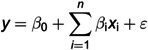 Figure 1
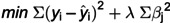 Figure 2
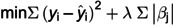 Figure 3
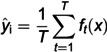 Figure 4
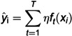 Figure 5
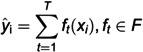 Figure 6
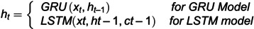 Figure 7
 Figure 8
 Figure 9
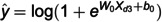 Figure 10
 Figure 11
 Figure 12
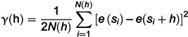 Figure 13
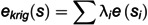 Figure 14
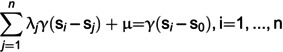 Figure 15
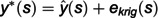 Figure 16
 Figure 17
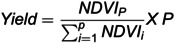 Figure 18
 Figure 19
 Figure 20
 Figure 21
 Figure 22
 Figure 23
 Figure 24
 Figure 25
 Figure 26
 Figure 27
 Figure 28
 Figure 29
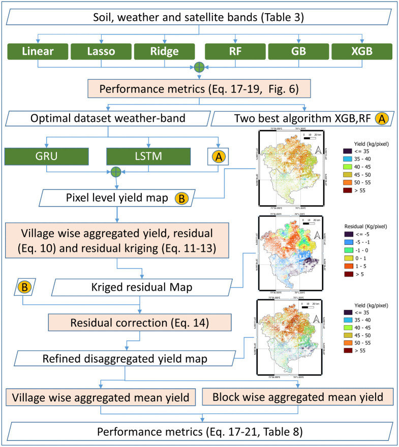 Figure 30
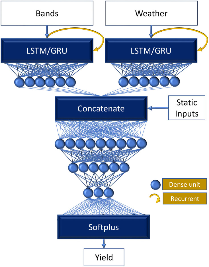 Figure 31
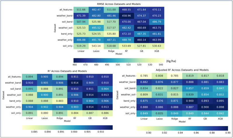 Figure 32
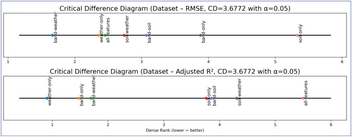 Figure 33
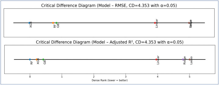 Figure 34
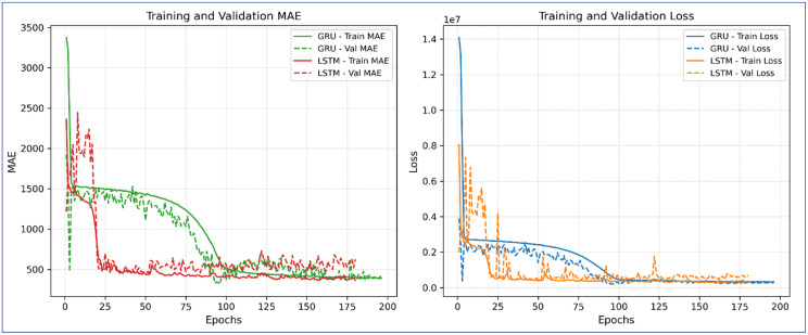 Figure 35
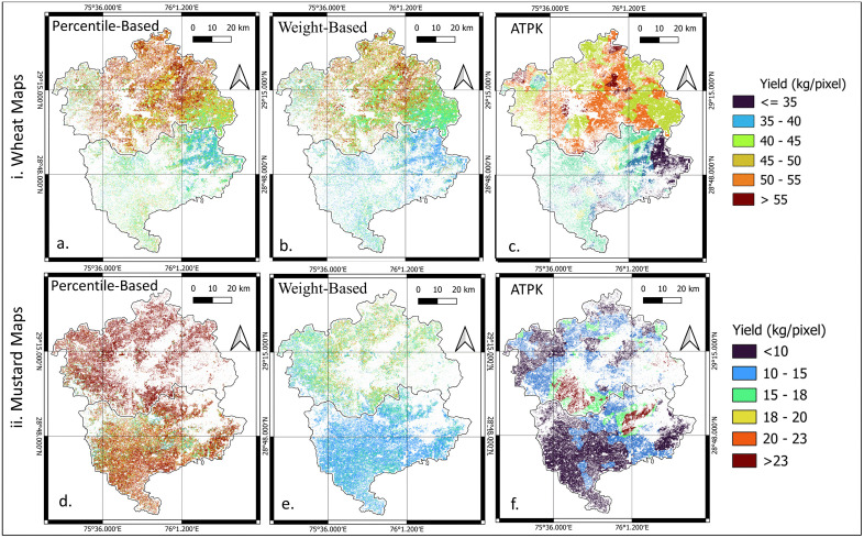 Figure 36
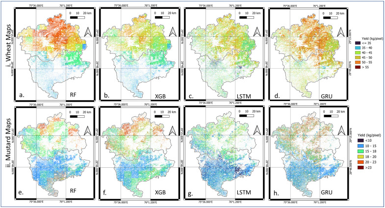 Figure 37
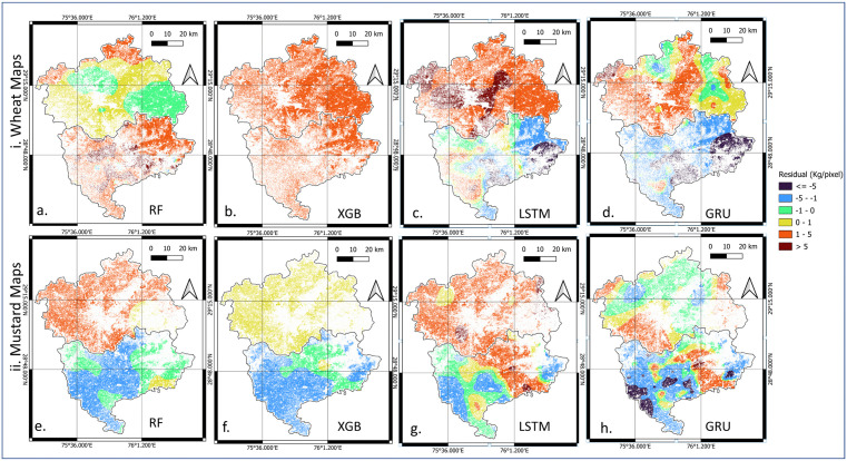 Figure 38
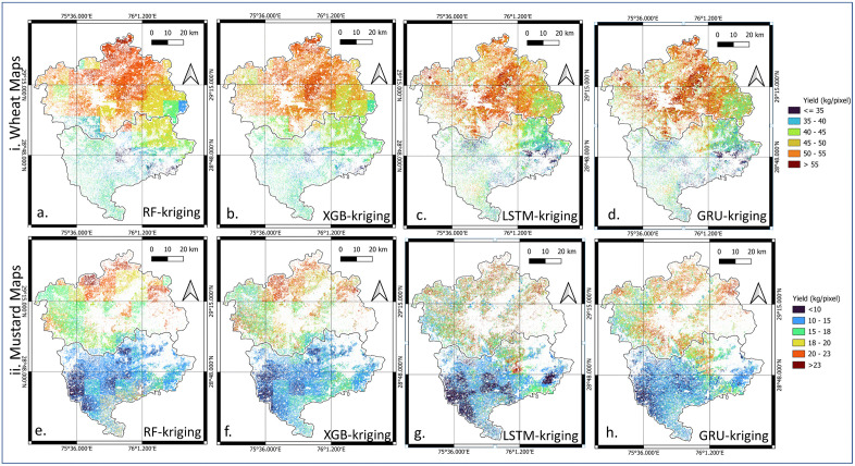 Figure 39
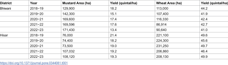 Figure 40
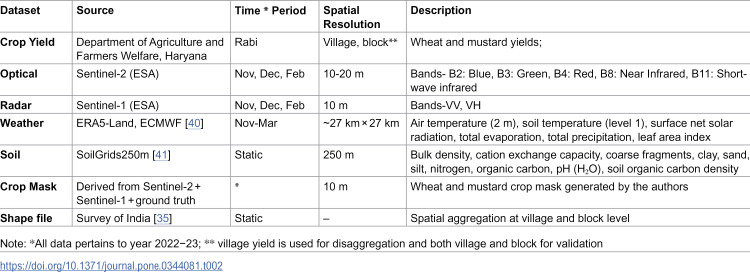 Figure 41
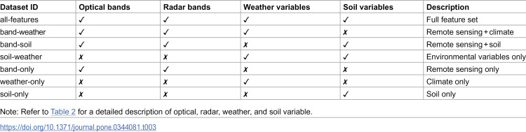 Figure 42
 Figure 43
 Figure 44
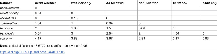 Figure 45
 Figure 46
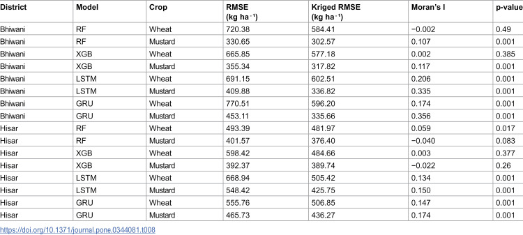 Figure 47
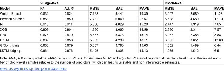 Figure 48
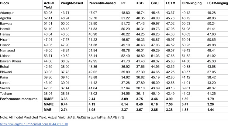 Figure 49
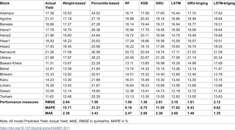 Figure 50
Peer Reviews
No public reviews on file for this paper yet. If you reviewed it on a platform where reviews are public (OpenReview, ICLR, NeurIPS, ICML), you can paste yours below so the community can read it here.
Videos
No videos yet. Explain this paper in a talk, walkthrough, or lecture? Add one.
Taxonomy
TopicsSoil Geostatistics and Mapping · Remote Sensing in Agriculture · Soil Moisture and Remote Sensing