Integrated assessment of ecological land capability and land suitability for irrigated agriculture in Alborz Province Iran
Mohammad Saber Baghkhanipour, Romina Sayahnia, Naghmeh Mobarghaee Dinan, Afshin Danehkar

TL;DR
This study integrates land capability and suitability assessments to improve sustainable agricultural planning in Alborz Province, Iran.
Contribution
The study introduces an integrated approach combining ecological land capability and land suitability assessments for irrigated agriculture.
Findings
Approximately 7% of Alborz Province is suitable for irrigated cultivation of four cereal crops.
Current irrigated agricultural area exceeds the suitable area, indicating overuse.
Improved accuracy in suitability measurement is achieved by adjusting temperature and water criteria.
Abstract
Increasing population density and improper land use have led to significant degradation of land resources, which is now a major environmental problem. A key challenge in sustainable agricultural planning is the separate application of land capability assessment (LCA) and land suitability assessment (LSE) methods in land spatial planning. The main objective of agricultural land suitability assessment is to assess the potential and constraints of land relative to the needs of target crops. This study aimed to develop a practical approach to integrate ecological LCA models with LSE models in Alborz province, Iran. Four cereal crops with a history of irrigated cultivation in the province were selected as target crops. The LCA model was integrated with the LSE model using nine factor-type and eight constraint-type criteria. The findings showed that approximately 7% of the province is…
Genes, proteins, chemicals, diseases, species, mutations and cell lines named across the full text — each resolved to its canonical identifier and authoritative record.
Click any figure to enlarge with its caption.
 Figure 1
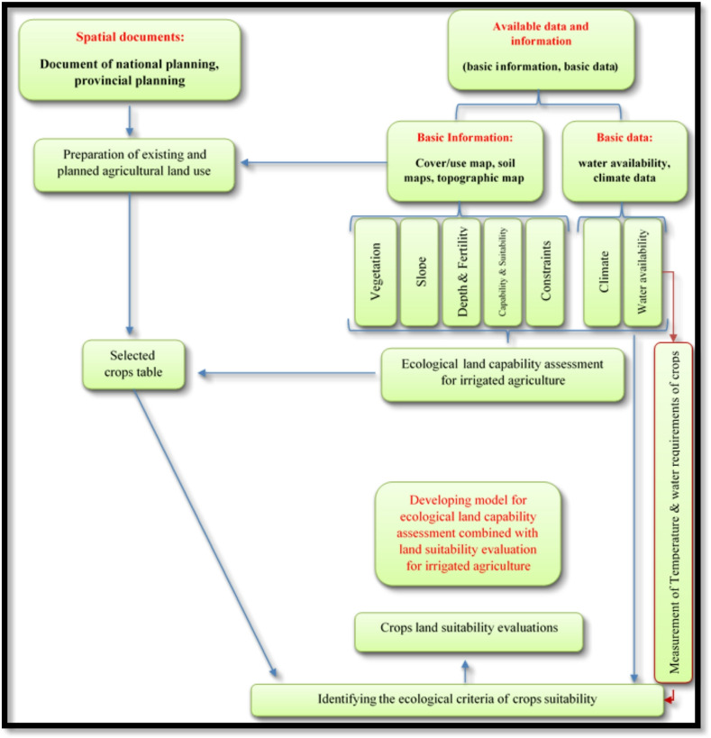 Figure 2
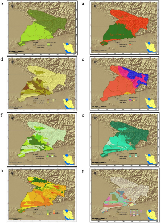 Figure 3
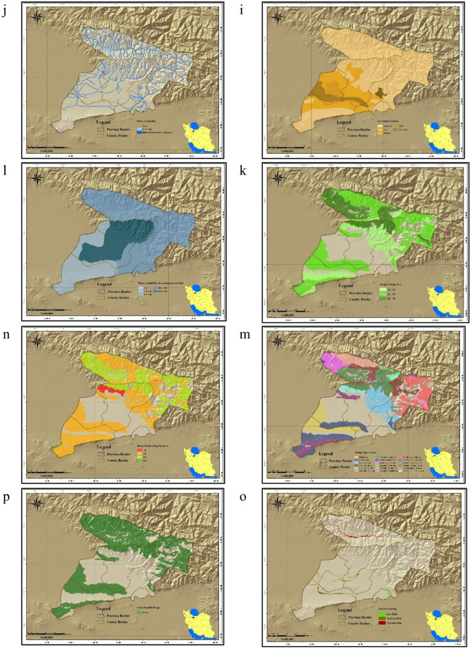 Figure 3
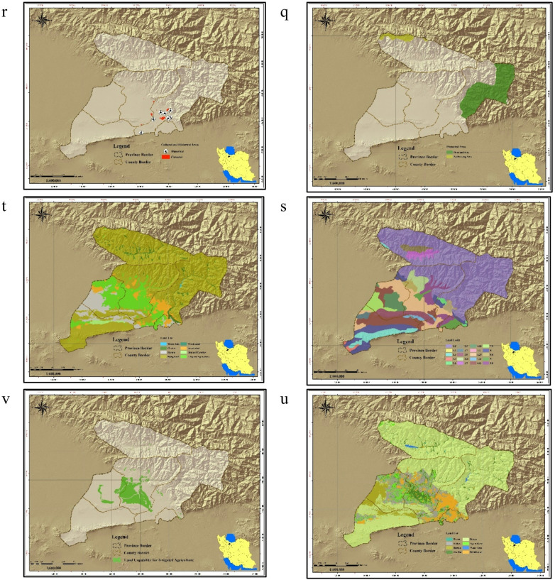 Figure 3
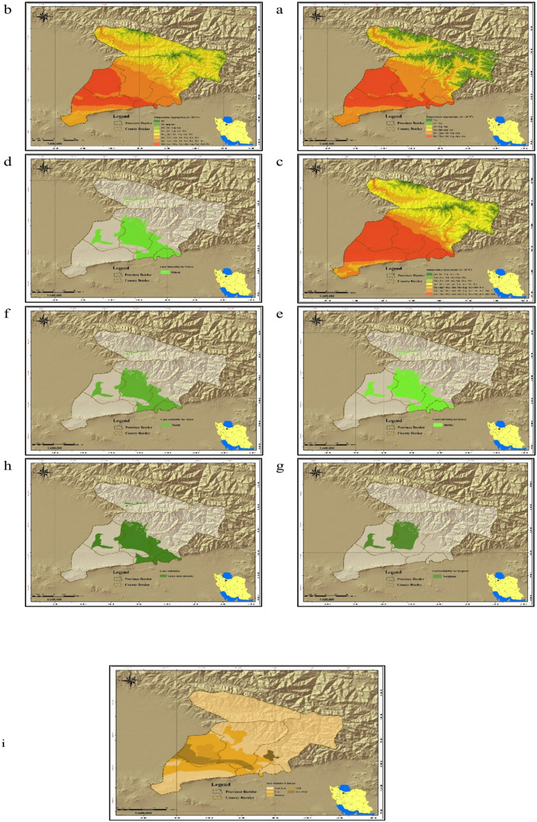 Figure 4
Peer Reviews
No public reviews on file for this paper yet. If you reviewed it on a platform where reviews are public (OpenReview, ICLR, NeurIPS, ICML), you can paste yours below so the community can read it here.
Videos
No videos yet. Explain this paper in a talk, walkthrough, or lecture? Add one.
Taxonomy
TopicsSoil and Land Suitability Analysis · Sustainable Agricultural Systems Analysis · Plant Ecology and Soil Science
Introduction
Agricultural production in many emerging nations is insufficient to meet the needs of expanding population^1^. Globally, sustainable food production has become a critical challenge, prompting many countries to prioritize agricultural development policies within their national agendas^2^.The Sustainable Development Goals state that by 2030, nations must put in place resilient agricultural methods that boost productivity and output, support the maintenance of ecosystems, and have the ability to adapt to changes. These methods help strengthen climate resilience and gradually improve the quality of land and soil^3,4^.
Meeting the food needs of growing populations is complicated by multiple drivers, including climate change, urban and industrial expansion, and unsustainable land use. These pressures result in overexploitation of water and soil resources, land conversion, and loss of native species. Consequences include rural depopulation, migration to cities, soil erosion, reduced land productivity, groundwater depletion, dust storms, poverty, food insecurity, and economic instability.
Additionally, its effects include village depopulation and an increase in migration to cities, as well as land destruction, soil erosion, a reduction in the productive capacity of the land, depletion of underground water resources, the creation of dust centers, increased poverty among the populace, a threat to food security, and economic instability within society^5–9^.
Scholars emphasize sustainable resource use based on environmental protection, ecological understanding, and technologies adapted to demographic conditions^2^. Achieving sustainable agricultural production requires macro-level planning and policy evolution^10^.
Given limited resources, decision-makers must adopt advanced land assessment methods to identify suitable areas for food production^11^.Given the limited availability of additional agricultural areas, it will be necessary to increase crop yields through wise land use and management strategies in order to meet the nutritional demands of future populations^12^. Sustainable Land Management (SLM) integrates land, water, biodiversity, and environmental management to increase productivity while preserving ecological functions^13^. SLM is a knowledge-based approach that combines land, water, biodiversity, and environmental management to meet rising demand for food and fiber crops without hurting the ecosystem or the livelihoods of those involved^14^. SLM aims to integrate the key sectors of agriculture, and the environment with economic and social factors^15^.
In Iran, crop production patterns are not aligned with the ecological capacity of the land^16^. Land Capability Assessment (LCA) is essential for efficient agriculture, as sustainable development requires land use that matches ecological potential^17,18^. Multi-Criteria Decision-Making (MCDM) methods play a key role in identifying high-yield areas while minimizing environmental impacts^19–22^.
LCA evaluates current ecological conditions, including climate, water, soil, vegetation, and habitats, to determine appropriate land use. In contrast, LSE identifies land suitable for specific crops based on ecological requirements, facilitating a transition from general land use to crop-specific suitability^23^.
LSE refers to the appropriateness of a specific area for a particular type of land use, as well as the extent to which it meets the requirements of the land user. It is evident that LSE is influenced by various constraints associated with different land utilization practices. LSE is the first step in the development and enhancement of spatial land planning and in supporting sustainable agriculture^24^. Agricultural LSE offers crucial data for agricultural development and long-term planning for agriculturalproduction^25^ (AL-Taani et al., 2020). The fundamental goal of agricultural LSE is to forecast the potentials and constraints of land parcels in relation to the growth of certain crops^26^. One of the challenges in sustainable agriculture planning in the process of spatial land planning is the separate utilization of Land Capability Assessment (LCA) methods and Land Suitability Evaluation (LSE) methods. At present, MCDM on the development of agricultural crops in Iran are done only by relying on LSE methods, and no attention is paid to the ecological potential of land. Among others, we can refer to the research of Kamkar et al., 2021^27^, Servati et al., 2017^28^, Zahirnia and Matinfar 2019^29^, Navidi et al. 2022^30^ and Safari et al. 2017^31^. Combining these two strategies allows for the potential of attaining sustainable agriculture to provide food security, water security, and biological security in an integrated way. This may be done by coordinating the growth of agricultural operations with prudent land management. Therefore, main goal of this research is to provide a model of agricultural LCA (ecological capacity) that includes LSE.
Many decision-making issues in regional planning are multi-criteria issues. MCDM and evaluation analysis have become one of the most powerful methods in planning in the past few decades. Multi-criteria analysis includes methods that allow a range of criteria related to a topic to be ranked, scored, and weighted; then the desired options are prioritized and selected. Different MCDM models, and sometimes their integration, are heavily employed in locating and assessing the ecological capacity of diverse applications, including agricultural land use^32^. In environmental research and land management, multi-criteria and spatial multi-criteria MCDM models have been frequently used. These models are intended to achieve various goals, which, by studying the sources, can be summarized as follows: LCA, Locating and LSE, Land sensitivity and vulnerability assessment, Natural hazards risk assessment, Environmental monitoring and supervision and Environmental restoration^33^.Access to appropriate MCDM methods and emerging technologies can facilitate the pursuit of this goal^34–36^.
The main research questions were as follows:
- Is it possible to incorporate LSE criteria into an ecological LCA model?
- Which ecological criteria can be used to make the LCA model to incorporate LSE?
A spatial MCDM approach is LSE analysis^20,21^. The advantages of incorporating multi-criteria decision analysis techniques, particularly those that use spatial data, into LSE were recognized by several scholars^20,37–39^. Notable works carried out in this field include LSE for ecotourism^40^, land suitability analysis for agricultural crops^21,41^, LSE for urban development^42^, LSE for irrigated wheat cultivation^43^ and multi-criteria LSE analysis for livestock development^19^.
Previous studies (Tashayo et al., 2020^24^; Amini et al., 2019^44^; Naswati et al., 2019 ; Aymen et al., 2021^45^ ; Sobhani and Nasiri, 2016^46^; AbdelRahman, et al., 2019^47^; AbdelRahman, et al., 2019^48^) have applied diverse approaches to LSE, including GIS-AHP, fuzzy logic, and analytical network processes, across crops such as corn, rice, and wheat in Iran and other regions. These works highlight the importance of integrating spatial data and multi-criteria methods for sustainable agricultural planning.
Materials and methods
Study area
The study area in this research is Alborz Province, Iran. This province covers an area of 5121.7 km^2^ located between 35°31′ and 36°12′ northern latitudes and 50°11′ and 51°29′ eastern longitudes. The cultivatable lands of the province lie within an elevation range of 900 and 1600 m above sea level^49^. Being located south of the Alborz Mountain range (Fig. 1), this province experiences two general climate type: cold and temperate in mountainous regions and warm and temperate in plains and desert regions. Alborz province, based on extended De Martonne climate classification, has the following climates types in the order of extent: arid, semi-arid, humid, very humid type 1, semi-humid, Mediterranean, and semi-humid type 2. Grade 2 and 3 rangelands cover around68% of the province area, followed by irrigated, rainfed, orchard, and fallow agricultural lands (19%), and developed areas including cities, towns, villages, industries, and infrastructure (7%), and bare terrain in the plains (5%)^50,51^. Less than 0.5% of Alborz Province is covered with scattered mountain forests and river valley groves, and about the same proportion is watered by both natural and artificial rivers and waterbodies^49^.
Fig. 1. Location map of the study area. Map generated by the authors using QGIS 3.28 (https://qgis.org/download/), based on Table 2 data cited in the National Ecological Land Capability Assessment Report (https://civilica.com/doc/1716634).
Research methodology
This study was interdisciplinary, descriptive-exploratory research with applied dimensions. It falls in the category of applied research in terms of purpose, and classifies as documentary-survey research because of using documentary. LCA methods for spatial land planning purposes rely on ecological LCA models. In the context of agriculture, these models determine which areas have a capacity for agricultural development (irrigated or rainfed), subject to land constraints. In Iran, conventional LCA models can only identify agriculturally-capable territories, but not the types of crops that would be suitable based on ecological characteristics. To resolve this issue, it is necessary to develop a new LCA model with the ability to determine the range of suitable crops for a given agricultural development project. It was assumed that agricultural development will take place via increased production of 4 crops that are already being cultivated in the study area: wheat, barley, maize, and sorghum. The LCA model was integrated with the LSE model for these crops to enhance the practicality of the LCA model for the target crops. Figure 2 illustrates the conceptual model of the research.
Fig. 2. Research conceptual model.
This study was conducted in three distinct stages, the methodology of which is detailed in the following subsections.
LCA method
In ecological LCA for agricultural purposes, it is common to use a number of capability criteria (so-called factors) plus a number of constraints in linear LCA models^52,53^.Competent ecological characteristics for irrigated agriculture are among the spatial parameters that might influence capacity evaluation. In 1993, Makhdoom created the first ecological LCA-MCDM model for Iran. This model operates based on four main ecological criteria, including water availability (in the range of 3000 to 10000 cubic meters per hectare per year), terrain roughness (slopes of less than 12%), soil characteristics (texture, depth, fertility, drainage), and climate. This model was updated and expanded by Danehkar et al. based on the country’s existing basic plans for the years 2017 to 2020. In addition to separating irrigated and rainfed agriculture, these researchers modified the MCDM model for irrigated farming so that it considers competence and constraint variables in relation to five ecological criteria, namely climate (average temperatures higher than 5 °C), terrain roughness (altitudes of less than 3000 m above sea level, slopes of less than 10%), soil characteristics (suitability for farming, soil orders, depth, fertility, drainage, and salinity), water availability in the basin (over 100 cubic meters per hectare per year) and natural vegetation (palatable rangelands and all forest habitats as constraint parameters) with improved precision.
With one adjustment, the soil order map of the irrigated agricultural LCA model was swapped out for the “resource and land assessment classes” (land unit classes) map in this study’s ecological LCA. The ecological LCA model of this study is provided in Table 1. In this model, agricultural sustainability is pursued with enough attention to environmental hazards (soil erosion and flooding), as well as those areas where agricultural development is not possible (culturally or ecologically significant areas, and areas within compatible land uses) so that assessment results can be used for conflict-free MCDM.
Table 1. Framework of the irrigated agriculture ecological LCA model for Alborz province.RowCriteriaCompetency range of capability indicatorsConstraint index range1Slope classUp to 10%More than 10%2Elevation sea level classUp to 1600 mMore than 1600 m3Average annual temperatureMore than 5 °CLess than 5 °C4Soil suitability class for agricultureI, IIIA, IIIS, IIIST, IIIT, IIIW + VA, IIS, IIST, IITIVS, IVT5Land unit2.1, 3.7, 3.21,4.2, 6.11, 7.9, 8.1, 8.4, 9.1, 9.81.1, 1.2, 1.4, 1.6, 2.3, 2.7, 2.9, 4.18, 4.25, 4.266Soil depth classLow to very highVery low depth7Soil fertility classMedium to goodWeak and very weak8Soil drainage classWeak to good–9Soil salinity class–High to very high10Forest cover–All forest habitats11Rangeland coverRangelands with the production of less than 200 kg/ha and coverage of less than 25%Rangelands with palatability species, produce more than 200 kg and cover more than 25%12Water availability in the basinMore than 100 m^3^/ha/yearLess than 100 m^3^/ha/yearConstraint due to natural hazards13Soil erosion class–High to severe14Flooding class–SevereConstraint due to incompatible land uses 15Culturally significant areas–Areas of ancient and historical value (buffer 500 m) 16Ecologically significant areas–National Park, national natural monument (not available in the province), wetlands, natural lakes, permanent rivers (buffer 150 m) 17Incompatible land use–Existing cities and industrial towns, lakes behind the dam (buffer 150 m)
The relevant national sources and the Alborz province’s spatial land planning database were used to gather the necessary information related to the aforementioned criteria. Table 2 contains a list of these data. The information layers corresponding to the criteria were prepared using GIS equipment (QGIS software) and classified based on competency ranges (Table 3). Considering the nature of criteria (compensating and non-compensating), union/intersection patterns of competency ranges for each criterion were integrated in the format of a linear model (Eq. 1) under the framework used in Danehkar’s national ecological LCA study^53^ to reach a linear LCA model for irrigated farming. This linear model is of the non-weighted type, since it is mandatory to include the criteria in MCDM. Then, the linear model layers were combined to generate an ecological LCA zoning map for irrigated farming.
Equation (1) linear model of irrigated farming LCA for Alborz province
\documentclass[12pt]{minimal} \usepackage{amsmath} \usepackage{wasysym} \usepackage{amsfonts} \usepackage{amssymb} \usepackage{amsbsy} \usepackage{mathrsfs} \usepackage{upgreek} \setlength{\oddsidemargin}{-69pt} \begin{document}$$\begin{aligned} {\mathrm{IA}} & ={\mathrm{SL1}}+{\mathrm{EL1}}+\left( {{\mathrm{TE2}},{\mathrm{TE3}},{\mathrm{TE4}}} \right)+\left( {{\mathrm{SS1}},{\mathrm{SS2}}} \right)+{\mathrm{LU1}}+\left( {{\mathrm{SD1}},{\mathrm{SD2}},{\mathrm{SD3}}} \right)+\left( {{\mathrm{SR1}},{\mathrm{SR2}},{\mathrm{SR3}},{\mathrm{SR4}}} \right) \\ & \quad +\left( {{\mathrm{SF1}},{\mathrm{SF2}},{\mathrm{SF3}}} \right)+\left( {{\mathrm{AW2}},{\mathrm{AW3}},{\mathrm{AW4}}} \right) - \left( {{\mathrm{SA3}},{\mathrm{FT1}},{\mathrm{RO1}},{\mathrm{EH2}},{\mathrm{FH2}},{\mathrm{PO1}},{\mathrm{PO2}},{\mathrm{PO3}}} \right) \\ \end{aligned}$$\end{document}In this equation, IA is the suitable zone for irrigated farming, SL denotes the slope class, EL denotes the elevation class, TE denotes the average temperature class, SS denotes the soil suitability class, LU denotes the land unit class, SD denotes the soil depth class, SF denotes the soil fertility class, SR denotes the soil drainage class, AW denotes the water availability class, SA denotes soil salinity class, FT denotes the forest cover class, RO denotes the non-developable rangeland class, EH denotes soil erosion class, FH denotes the flood susceptibility class, and PO denotes the class of culturally, historically, ecologically sensitive areas and areas with incompatible land uses.
Table 2. Information layers used in the LCA and LSE of the study area.RowInformation layerScaleReferences1Elevation classes1:250,000Topographic map of Iran National Cartographic Center2Slope classes1:250,000Topographic map of Iran National Cartographic Center3Isothermal classes1:250,000Data of Iran Meteorological Organization - Topographic map of Iran National Cartographic Center4Soil suitability classes1:100,000LCA map prepared by Soil and Water Research Institute of Iran5Soil depth classes1:100,000LCA map prepared by Soil and Water Research Institute of Iran6Soil fertility classes1:100,000LCA map prepared by Soil and Water Research Institute of Iran7Soil drainage classes1:100,000LCA map prepared by Soil and Water Research Institute of Iran8Soil salinity classes1:250,000LCA map prepared by Soil and Water Research Institute of Iran9Land unit classes1:100,000LCA map prepared by Soil and Water Research Institute of Iran10Classes of water availability for agricultural1:250,000Comprehensive plan of water resources management - Iranian Ministry of Energy11Forest type classes1:250,000Vegetation map - Natural Resources and Watershed Management Organization of Iran12Forest dense classes1:250,000Vegetation map - Natural Resources and Watershed Management Organization of Iran13Rangeland type classes1:250,000Vegetation map - Natural Resources and Watershed Management Organization of Iran14Rangeland palatability classes1:250,000Vegetation map - Natural Resources and Watershed Management Organization of Iran15Rangeland dense classes1:250,000Vegetation map - Natural Resources and Watershed Management Organization of Iran16Classes of protected areas1:250,000Iran’s Department of Environment17Soil erosion classes1:250,000LC map prepared by Soil and Water Research Institute of Iran18Flooding classes1:100,000Geological map of Geological Survey and Mineral Exploration of Iran19Areas of ancient and historical value1:25,000Topographic map of Iran National Cartographic Center20Water resources (rivers and water bodies)1:100,000Geological map of Geological Survey and Mineral Exploration of Iran21Land use1:50,000Land cover and land use map of Alborz province - Provincial spatial land planning document
Table 3. Irrigated farming LCA and LSE classes for Alborz province.CriteriaClass 1Class 2Class 3Class 4% Slope Range0–10> 10 CodeSL1SL2Elevation class Range1600>> 1600 CodeEL1EL2Average annual air temperature (ºC) Range5>5–1010–1515–20 CodeTE1TE2TE3TE4Average monthly air temperature (ºC) Range2–88–1414–3030–40 CodeTM1TM2TM3TM4Growth period (days) Range90–100100–120120–130130–160 CodeGC1GC2GC3GC4Soil suitability RangeIIIIA, IIIS, IIIST, IIIT, IIIW + VA, IIS, IIST, IITIVS, IVT CodeSS1SS2SS3Land unit Range2.1, 3.7, 4.2, 8.1, 8.4, 9.11.1, 1.2, 1.4, 1.6, 2.3, 2.7, 3.1,4.1 CodeLU1LU2Soil depth (cm) RangeHigh (75< )Relatively high (50–75)Relatively low to low (50 − 25)Very low (25> ) CodeSD1SD2SD3SD4Soil fertility RangeGoodRelatively goodMediumWeak CodeSF1SF2SF3SF4Soil drainage RangeGoodMediumImperfectWeak CodeSR1SR2SR3SR4Soil salinity RangeVery lowLowLow to mediumHigh to very high CodeSA0SA1SA2SA3Forest cover RangeWithout coverHas cover CodeFT0FT1Rangeland cover RangeProduction less than 200 kg and coverage less than 25%Palatability species, produce more than 200 kg and cover more than 25% CodeRO1RO2Water availability (m^3^/hectare/year) Range100>100–500500–10001000< CodeAW1AW2AW3AW4Soil erosion RangeVery low to mediumRelatively high to very high CodeEH1EH2Flooding RangeRelatively mildMediumSevere CodeFH0FH1FH2Non-developable RangeHistorical-culturalEcologically significantIncompatible CodePO1PO2PO3
LSE method
LSE models rely on the analyses conducted for a series of target crops. Such LSE models can be described as an environment friendly approach to land use management for agricultural development. In this approach, target crops are assessed based on their ecological requirements and the range of geographic factors in the environment under study. Four different varieties of cereals that have historically been grown under irrigation in the region of Alborz were the study’s target crops. Since it could be challenging to identify the right environmental criteria for agricultural productivity, researchers proposed different criteria with varying components and scopes for this purpose. However, these criteria were determined using the book “Land Evaluation”^54^ as the main reference and other related articles serving as supplementary references.
Accordingly, the information available in the NETWAT^55^ software database of the study area, and data from scientific articles was used to extract criteria for target crop and their reported ranges of values^55–58^. It should be noted that these factors were eliminated from the table of LSE criteria (Table 4) to prevent interference, since NETWAT determines the net irrigation water demand based on effective precipitation (in millimeters) and evapotranspiration(in millimeters).
Furthermore, in the mentioned table, temperature range and minimum water availability were assumed to correspond to a yield of over 40%. The long-term meteorological data of Alborz province from local synoptic stations and their linear gradients were used to generate temperature zone maps based on the needs of each crop and the time required to achieve the minimum planned production. Isotherm maps for all months of the year were also obtained. Table 5 shows the average monthly temperature in 16 meteorological stations of Alborz province in the period from 1956 to 2019.
The data needed for LSE was applied in accordance with Table 2. Based on linear correlations between the ranges of appropriate values of the criterion for each crop, LSE mapping for the target crops was carried out using the minimal range of parameters provided in Table 4 for yields above 40%. The LSE conducted in this study only covered those parts of the province that had either agricultural land use or no designated land use at all.
Table 4. Range of irrigated agriculture suitability criteria for the target cereals.Criteria% productionWheatBarleyMaizeSorghumGrowth period (days)–100–130120–16090–13090–130Water availability for agriculture (m^3^/hectare)505005001200130075700700310031001001500<1500<4000<4000<% Slope40>10<10<10<10<40–608–1010<8–108–1060–854–88–104–84–885–952–42–82–42–495–1000–20–20–20–2Average monthly air temperature (ºC)40>8>30<2>42<12>40<12>32<40–608–1026–302–436–4214–1634–4014–1860–8510–1224–264–630–3616–1832–3418–2285–9512–1420–246–824–3018–2226–3222–2426–3295–10014–208–2422–2624–26Soil depth (cm)40>10>10>10>10>40–6010–2010–2020–5010–2060–8520–5020–5050–7520–5085–9550–9050–9075–10050–9095–10090<90<100<90<Soil drainage40>Very weakVery weakVery weakVery weak40–60WeakWeakWeakWeak60–85ImperfectImperfectImperfectImperfect85–95MediumMediumMediumMedium95–100GoodGoodGoodGoodSoil salinity40>Very weakVery weakVery weakVery weak40–60WeakWeakWeakWeak60–85MediumMediumMediumMedium85–95GoodGoodGoodGood95–100ExcellentExcellentExcellentExcellent
Table 5. Average monthly and annual temperatures of meteorological stations in the study area.Elevation (m)Station nameParameterOctoberNovemberDecemberJanuaryFebruaryMarchAprilMayJuneJulyAugustSeptemberAnnual1417Deh SomeeAverage14.947.822.770.792.577.0212.2116.6321.4523.8823.3119.8012.771220ValadabadAverage13.997.381.38− 2.64− 0.056.9013.1417.8022.1825.2324.5520.5112.531193KarimabadAverage16.2110.094.240.240.745.3511.3416.5422.3026.0526.0122.4513.461886AsaraAverage11.935.11− 1.42− 3.72− 2.012.929.6214.7120.1423.8922.9018.4210.212170NesaAverage10.424.33− 1.88− 4.37− 3.191.377.7612.6817.3520.5219.8916.158.422530GagereAverage10.134.96− 0.60− 4.74− 6.60− 2.972.599.2313.5917.8418.3215.366.432173ShahrestangAverage10.514.25− 1.65− 4.79− 2.811.767.3912.4717.4621.2220.9616.628.621322KarajAverage17.119.914.561.814.128.6714.5319.2124.5827.1026.6922.7415.091311HaidarabadAverage15.598.084.451.612.167.4612.9017.0622.1624.2123.9021.5613.431807KarajmicroclimatologyAverage15.379.132.07− 0.721.077.0713.5518.3123.6426.2724.4521.7713.581726Karaj DamAverage14.578.283.431.122.636.5812.2217.0722.1824.8324.0120.5013.121652SolghanAverage14.277.833.211.532.595.3512.4317.4523.4226.1024.9721.0413.351953JostanAverage14.497.972.760.66− 0.693.048.0313.0818.3121.9522.6519.8811.012155DarvanAverage12.957.450.70− 2.65− 3.03− 0.026.0811.5516.9522.2522.7019.659.551885ZidashtAverage14.147.431.61− 1.59− 1.681.857.7412.6918.1922.0922.6819.7610.411807GlinkAverage11.853.42− 2.14− 5.03− 3.99− 0.835.4610.4215.6120.2720.5516.967.71
Method of LSE-based ecological LCA
The integration of information maps in GIS produces a map of suitability zones for the target crops. Following the approach used in previous models and the one applied in Danehkar’s national ecological LCA^53^, the LCA model was developed by the aggregating of the value range of the criteria from the LSE models for the selected crops. Next, this model was modified to incorporate LSE into LCA, enabling it to identify both the potential for product development and the agricultural activity group (irrigated). This leads to more practical results from spatial land zoning and relates land plans to agricultural calendar, as well as spatial patterns, thereby increasing the added value gained from agricultural land. This innovation in applying ecological LCA models can serve as a platform for improved spatial land planning. After preparing the LCA model based on the suitability of agricultural crops, the ecological LCA was repeated to generate another map. This map can be compared with the ecological LCA maps (Fig. 3, u, v) presented in master (provincial or national) land spatial planning documents to achieve more accurate LSE maps.
Results
LCA results
LCA of the study area for the development of irrigated agriculture was performed using the descriptive model (Table 1) and linear relationship (Eq. 1) obtained for the area. The LCA analysis produced criteria maps for nine factors and eight constraints (Fig. 3a–v). Precipitation in the study area ranged from < 200 to 1000 mm, indicating that crops requiring higher rainfall are unsuitable unless supplemented by groundwater. Water availability varied between < 100 and 2000 m³/ha/year, with most of the area falling in the 500–1000 m³/ha/year class (Fig. 3l). Soil drainage ranged from good to poor, while fertility was predominantly very poor (Fig. 3f). Average monthly temperatures ranged from < 5 °C to 20 °C, with the 10–15 °C range covering the largest area. Slopes < 10%—most suitable for irrigated farming—were the least frequent class (Fig. 3a). Integration of these criteria in QGIS (Eq. 1) identified lands with ecological capability for irrigated farming (Fig. 3v).
Fig. 3. Thematic maps used in ecological land capability assessment; (a) slope classes; (b) elevation classes; (c) temperature classes; (d) soil depth; (e) soil drainage; (f) soil fertility; (g) soil suitability; (h) soil erosion; (i) soil salinity; (j) water availability; (k) rangeland canopy; (l) water availability for agriculture; (m) rangeland types; (n) rangeland productivity; (o) flood risk; (p) undevelopable rangelands; (q) protected areas; (r) cultural and historical areas; (s) land units; (t) land use map (national planning); (u) land use map (provincial planning); (v) ecological land capability map for irrigated agriculture. Map generated by the authors using QGIS 3.28 (https://qgis.org/download/), based on Table 2 data cited in the National Ecological Land Capability Assessment Report (https://civilica.com/doc/1716634).
LSE results
LSE was conducted for four cereal crops using climate, soil, water, and topography criteria. Barley tolerated the widest temperature range (> 40 °C), while wheat and barley could grow below 10 °C. Most crops required medium to excellent soil fertility (≥ 1% organic carbon). Suitability maps (Fig. 3a–u) were generated for each criterion. Linear relationships between ecological parameters were derived for each crop (Eqs. 2–5), enabling crop-specific suitability mapping. A critical determinant was temperature continuity: maize and sorghum required 90–130 consecutive days of suitable temperatures, wheat 100–130 days, and barley 120–160 days (Table 6). The optimal range for all crops was 14–30 °C, supporting > 95% yield over five months (Fig. 4a). Other ranges (30–32 °C, 8–40 °C, 2–42 °C) supported progressively lower yields (Fig. 4b–c). Final suitability maps for wheat, barley, maize, and sorghum are shown in Fig. 4d–h.
Equation (2) Linear relationship of combinations of irrigated wheat farming LSE criteria for Alborz province
\documentclass[12pt]{minimal} \usepackage{amsmath} \usepackage{wasysym} \usepackage{amsfonts} \usepackage{amssymb} \usepackage{amsbsy} \usepackage{mathrsfs} \usepackage{upgreek} \setlength{\oddsidemargin}{-69pt} \begin{document}$$\begin{aligned} {\mathrm{IAW}} & ={\mathrm{SL1}}+\left( {{\mathrm{TM2}},{\mathrm{TM3}}} \right)+\left( {{\mathrm{SD1}},{\mathrm{SD2}},{\mathrm{SD3}},{\mathrm{SD4}}} \right)+\left( {{\mathrm{SR1}},{\mathrm{SR2}},{\mathrm{SR3}}} \right) \\ & \quad +\left( {{\mathrm{SF1}},{\mathrm{SF2}},{\mathrm{SF3}},{\mathrm{SF4}}} \right)+\left( {{\mathrm{AW2}},{\mathrm{AW3}},{\text{ AW4}}} \right) \\ \end{aligned}$$\end{document}Equation (3) Linear relationship of combinations of irrigated barley farming LSEcriteria for Alborz province
\documentclass[12pt]{minimal} \usepackage{amsmath} \usepackage{wasysym} \usepackage{amsfonts} \usepackage{amssymb} \usepackage{amsbsy} \usepackage{mathrsfs} \usepackage{upgreek} \setlength{\oddsidemargin}{-69pt} \begin{document}$$\begin{aligned} {\mathrm{IAB}} & ={\mathrm{SL1}}+\left( {{\mathrm{TM1}},{\mathrm{TM2}},{\mathrm{TM3}},{\mathrm{TM4}}} \right)+\left( {{\mathrm{SD1}},{\mathrm{SD2}},{\mathrm{SD3}},{\mathrm{SD4}}} \right)+\left( {{\mathrm{SR1}},{\mathrm{SR2}},{\mathrm{SR3}}} \right) \\ & \quad +\left( {{\mathrm{SF1}},{\mathrm{SF2}},{\mathrm{SF3}},{\mathrm{SF4}}} \right)+{\text{ }}\left( {{\mathrm{AW2}},{\mathrm{AW3}},{\mathrm{AW4}}} \right) \\ \end{aligned}$$\end{document}Equation (4) Linear relationship of combinations of irrigated maize farming LSE criteria for Alborz province
\documentclass[12pt]{minimal} \usepackage{amsmath} \usepackage{wasysym} \usepackage{amsfonts} \usepackage{amssymb} \usepackage{amsbsy} \usepackage{mathrsfs} \usepackage{upgreek} \setlength{\oddsidemargin}{-69pt} \begin{document}$${\mathrm{IAM}}={\mathrm{SL1}}+\left( {{\mathrm{TM2}},{\mathrm{TM3}},{\mathrm{TM4}}} \right)+\left( {{\mathrm{SD1}},{\mathrm{SD2}},{\mathrm{SD3}},{\mathrm{SD4}}} \right)+\left( {{\mathrm{SR1}},{\mathrm{SR2}},{\mathrm{SR3}}} \right)+\left( {{\mathrm{SF1}},{\mathrm{SF2}},{\mathrm{SF3}},{\mathrm{SF4}}} \right)+\left( {{\mathrm{AW4}}} \right)$$\end{document}Equation (5) Linear relationship of combinations of irrigated sorghum farming LSE criteria for Alborz province
\documentclass[12pt]{minimal} \usepackage{amsmath} \usepackage{wasysym} \usepackage{amsfonts} \usepackage{amssymb} \usepackage{amsbsy} \usepackage{mathrsfs} \usepackage{upgreek} \setlength{\oddsidemargin}{-69pt} \begin{document}$${\mathrm{IAS}}={\mathrm{SL1}}+\left( {{\mathrm{TM2}},{\mathrm{TM3}},{\mathrm{TM4}}} \right)+\left( {{\mathrm{SD1}},{\mathrm{SD2}},{\mathrm{SD3}},{\mathrm{SD4}}} \right)+\left( {{\mathrm{SR1}},{\mathrm{SR2}},{\mathrm{SR3}}} \right)+\left( {{\mathrm{SF1}},{\mathrm{SF2}},{\mathrm{SF3}},{\mathrm{SF4}}} \right)+\left( {{\mathrm{AW4}}} \right)$$\end{document}Results of ecological LCA based on LSE
Integration of LCA and LSE through MCDM enhanced model performance by incorporating temperature continuity. Comparative analysis of two MCDM methods showed that adding temperature ranges allowed outputs to reflect both land capacity and crop composition. Temperature–humidity requirements for the four crops are summarized in Table 7. Using these criteria, ecological LCA maps were generated (Fig. 4i). Replacing average annual temperature with monthly temperature continuity (Table 8) improved accuracy, effectively transforming the LCA into a capability–suitability assessment model. This integrated approach provides more reliable identification of suitable lands for irrigated cereal cultivation in Alborz Province.
Table 6. Temperature requirements of the target crops based on percent yield.ProductWheatMaizeSorghumBarleyGrowth period100–130 days90–130 days90–130 days120–160 daysAverage monthly temperature% Production42>40>40>40>40>40–4240>40>40>40–6038–4040>40–6040>40–6036–3840>40–6040>40–6034–3640>40–6040>60–8532–3440>60–8540>60–8530–3240>85–9585–9560–8528–3040–6085–9585–9585–9526–2840–6085–9585–9585–9524–2660–8595–10095–10085–9522–2485–9595–10085–9595–10020–2285–9585–9560–8595–10018–2095–10085–9560–8595–10016–1895–10060–8540–6095–10014–1695–10040–6040–6095–10012–1485–9540>40>95–10010–1260–8540>40>95–1008–1040–6040>40>95–1006–840>40>40>85–954–640>40>40>60–852–440>40>40>40–60
Table 7. Temperature-humidity requirements of the target crops in the study area.Average monthly temperatures °CGrowth periodWater availability (m^3^/hectare/year)100–500500–10001000–15001500–200014–303 monthsWheatWheat, MaizeWheat, Maize, SorghumWheat, Maize, Sorghum30–32–Wheat, MaizeMaize, SorghumMaize, Sorghum8–40WheatWheat, MaizeWheat, Maize, SorghumWheat, Maize, Sorghum2–40––––14–304 monthsWheat, BarleyWheat, Barley, MaizeWheat, Barley, Maize, SorghumWheat, Barley, Maize, Sorghum30–32BarleyBarley, MaizeBarley, Maize, SorghumBarley, Maize, Sorghum8–40Wheat, BarleyWheat, Barley, MaizeWheat, Barley, Maize, SorghumWheat, Barley, Maize, Sorghum2–42BarleyBarleyBarleyBarley14–305 monthsBarleyBarleyBarleyBarley30–32BarleyBarleyBarleyBarley8–40BarleyBarleyBarleyBarley2–42BarleyBarleyBarleyBarley
Table 8. New temperature criterion and its appropriate range for upgrading the ecological LCA model for the target crops.ConstraintCapabilityCriterionAverage monthly temperatures below 2 °C and over 42 °CContinuous average monthly temperatures of 2–42 °C over a period of 1–5 months, subdivided into four ranges: 14–30 °C, 30–32 °C, 8–40 °C, and 2–42 °CSuitable air temperature
Fig. 4. Thematic maps used in ecological land capability assessment; (a) temperature appropriate map (14–28 °C); (b) temperature appropriate map (8–28 °C); (c) temperature appropriate map (2–28 °C); (d) wheat land suitability evaluation (LSE) map; (e) barley LSE map; (f) maize LSE map; (g) sorghum LSE map; (h) cereals LSE map; (i) ecological land capability–suitability map. Map generated by the authors using QGIS 3.28 (https://qgis.org/download/), based on Table 2 data cited in the National Ecological Land Capability Assessment Report (https://civilica.com/doc/1716634).
Discussion
Anthropogenic depletion of natural resources has raised concerns about ecosystem health and global food security. Sustainable Land Management (SLM) is widely recognized as a key strategy to prevent land degradation and ensure long-term agricultural productivity. In this study, SLM is considered within the framework of Land Capability Assessment (LCA) and Land Suitability Evaluation (LSE), which together provide a basis for aligning agricultural practices with ecological conditions.
The anthropogenic depletion and destruction of natural resources, which has caused major concerns regarding ecosystem health and global food security, is rooted in humans’ misconceptions about nature and the consequent misuse of natural resources. It is vital to assess the food security status of both urban and rural communities and to identify the factors influencing this status, given the importance of food security in achieving comprehensive development and fostering a healthy, active population^59^. Therefore, SLM can be viewed as a protective measure against land degradation, aimed at preventing the destruction of land resources. In this context, one may ask: what is the exact definition of land degradation? The Global Environment Facility defines land degradation as any decline in the natural potential of land that adversely affects an ecosystem’s integrity by reducing its ecological productivity, natural bioavailability, and recovery capacity. According to the World Bank, Sustainable Land Management (SLM) is essential for meeting the needs of the world’s growing population. This international institution warns that poor land management can lead to land degradation, resulting in a significant reduction in a nation’s productive and service outputs^14^. Therefore, SLM can be viewed as a protective measure against land degradation, aimed at preventing the destruction of land resources. In this context, one may ask: what is the exact definition of land degradation? The Global Environment Facility defines land degradation as any decline in the natural potential of land that adversely affects an ecosystem’s integrity by reducing its ecological productivity, natural bioavailability and recovery capacity^60,61^. One of the most important aspects of Sustainable Land Management (SLM) is the alignment of agricultural activities with environmental conditions^2^. Therefore, Land Capability Assessments (LCAs) are crucial for efficient agriculture, as optimal land use requires an accurate assessment of ecological resources12. Land Suitability Evaluation (LSE) is the first step in the development and enhancement of spatial land planning, and in supporting sustainable agriculture19. In the context of agriculture, this process is referred to as LSE, and its primary goal is to forecast the potentials and constraints of individual land parcels in relation to the production of specific crops21. This study makes three main contributions: (1) updating and applying an ecological LCA model for irrigated agriculture in Alborz Province, (2) integrating constraint-type criteria into LCA, which are often neglected, and (3) combining LCA with crop-specific LSE to improve accuracy by incorporating temperature continuity. However, the original word-based model of Makhdoom (1993) requires updating and modification a matter that was duly noted by some users but overlooked by others. It is important to note that in all cases involving the use of LCA models, decisions were made based on criteria related to the land’s ecological resources. However, the fundamental ecological SLM model, utilized in the nation’s national spatial land planning document44 and customized for Alborz Province, was employed to conduct the LCA for irrigated agriculture in this research. All ecological LCA models operate based on the assumption that having optimal ecological conditions is a necessary requirement for realizing the maximum land potential. The basic principle of LCA in these models is to evaluate the natural capability of the environment without any remediation or artificial adjustment. In other words, these models measure the inherent ecological potential of the environment43.Weighting methods are generally not well-suited for ecological assessments and tend to be ineffective when applied exclusively to ecological data (i.e., physical and biological resources)51. Therefore, it is reasonable to avoid weighting ecological criteria in LCA, which is why this approach was deliberately excluded from this study. The LCA model used for irrigated agriculture in Alborz Province included nine capability criteria and eight constraints. Several other studies including Chen et al. (2021)^62^, Altani et al. (2020)^25^, Di Feudis et al. (2020)^63^, Nguyen et al. (2020)^64^, Mazahreh et al. (2019)^26^, Atalay (2016)^65^, Akinsi et al. (2013)^21^, Safaripour and Naseri (2020)^66^, Bidadi et al. (2015)^17^, and Pourkhabbaz et al. (2015)^18^ have applied these criteria in LCA. However, very few studies have incorporated constraint-type criteria in this MCDM process.
This neglect stems from the fact that the nature of LCA tends to direct the researcher’s focus toward capability factors, while drawing attention away from constraint factors. However, it is important to remember that careful consideration of restriction factors is essential for managing capability components and establishing precise spatial boundaries. In reality, in situations where progress may be severely limited, capability elements alone are insufficient. Application of the irrigated agriculture LCA model revealed that only 6% of Alborz Province is suitable for irrigated agriculture. This contrasts sharply with the provincial spatial land planning document^49^, which identified 19% as suitable for agriculture and 11% for irrigated agriculture. The difference highlights the importance of incorporating ecological constraints into LCA, as conventional planning may overestimate land suitability. The irrigated agriculture LCA model used in this study does not account for irrigated orchards, particularly those located on sloping lands. This indicates that such agricultural systems require a dedicated and specialized model tailored to their unique ecological and spatial characteristics. In the context of agriculture, Land Suitability Evaluation (LSE) must be conducted for specific target crops. In this study, the target crops consisted of four cereal types, for which four main LSE criteria climate, soil, water availability and topography were applied, along with nine sub-criteria: monthly average temperature, soil suitability, land unit, soil drainage, soil depth, soil fertility, available water, and slope. According to the study’s findings, 7% of the province is suitable for producing these four major cereal crops, with a considerable portion of that area being ideal for cultivating common cereals with strong ecological adaptability, such as maize, wheat, and barley.
It is important to note that careful attention to the ecological requirements of each specific crop not only enables more accurate delineation of suitability zones, but also expands the spatial scope of LSE, especially when temperature ranges overlap across both monthly and seasonal periods (e.g., 2–42 °C).
These findings are consistent with previous studies that applied GIS-AHP, fuzzy logic, and other MCDM approaches to crop suitability analysis in Iran and abroad(Tashayo et al. (2020)^24^, Amini et al. (2019)^44^, Neswati et al. (2019)^12^, Aymenet al. (2021)^45^, Sobhani and Nasiri, (2020)^46^. The present study extends this work by explicitly integrating LCA and LSE, and by incorporating constraint-type criteria and temperature continuity into the assessment.
Conclusion
This study aimed to develop a practical solution for integrating ecological LCA models with crop-centered LSE models in the agricultural sector. Since both models rely on ecological criteria, it was hypothesized that they could be combined through modification of decision components and refinement of the appropriate range of environmental factors. In addition to confirming this hypothesis, the results demonstrated that a capability-based LSE model can be effectively constructed by replacing average annual temperature with average monthly temperature, incorporating temperature continuity (based on the growth period of target crops), and improving the accuracy of minimum water availability mapping using grade 4 basins (609 basins across Iran).
The model’s performance was validated through a case study in Alborz Province, involving four cereal crops. It successfully refined the results of the irrigated agriculture LCA model while producing overlapping outcomes with the LSE model for agricultural development in the region. Given that approximately 200 agricultural crops are currently cultivated in Iran, the development of this MCDM model will significantly contribute to spatial land planning, facilitating the creation of knowledge-based agricultural development plans aligned with LCA principles. The results of such assessments can be used to generate agricultural species distribution maps that align with ecological LCA, thereby supporting efforts to achieve and maintain food security. Also, given that in land planning studies, the needs of agricultural plant species and crop suitability are not considered in assessing the ecological potential of irrigated agricultural lands, the results of this finding can improve this decision-making system.
Suggestions
- Integration of Economic and Social Dimensions as complementary research, it is recommended to incorporate economic and social components into environmental suitability studies. Factors such as market access, agricultural policies, and farmers’ technology adoption significantly influence land use decisions. Including these dimensions will help develop a more comprehensive decision support tool for policymakers and enhance the practical applicability of ecological models.
- Enhancement of Soil Data Accuracy Field-level investigations require more accurate soil profile data and detailed soil descriptions. Additionally, attention to parameters such as micro-nutrient availability and soil composition variability would significantly improve the precision of land suitability assessments.
- Inclusion of Crop-Specific Needs in Land Planning Current land planning studies often overlook the specific ecological requirements of agricultural plant species and product suitability when assessing the potential of irrigated agricultural lands. Addressing this gap can enhance the decision-making framework. This recommendation is directed to the Planning and Budget Organization of the Iranian Government, as a key authority in national land use policy.
- Expansion to Other Agricultural Land Types This study focused exclusively on irrigated agricultural lands. Future research should extend the scope to include rainfed, orchard, and fallow lands, thereby enabling a more holistic evaluation of agricultural potential across diverse land types.
The reference list from the paper itself. Each links out to its DOI / PubMed record.
- 1Alizadeh, A. et al. A.H., Water requirement of plants in Iran, Imam Reza University Publication, p. 228. (2000).
- 2Abdel Rahman, M. A. E., Saleh, A. M. & Arafat, S. M. Assessment of land suitability using a soil-indicator-based approach in a geomatics environment. Sci Rep 12, 18113 (2022). 10.1038/s 41598-022-22727-7 E. Abdel Rahman, M., Engel, B., S. M. Eid, M., & M. Aboelsoud, H. (2022). A new index to assess soil sustainability based on temporal changes of soil measurements using geomatics – an example from El-Sharkia, Egypt. All Earth, 34(1), 147–166. https://doi.org/10.1080/27669645.2022.2103953.10.1038/s 4 · doi ↗ · pubmed ↗
- 3Abdel Rahman, M. A. Reimagining soil stewardship in the anthropocene: Nature-positive pathways, pedological perspectives, and land use innovations for soil health and security. Soil Security, 100206. (2025).
- 4Center for Development and Foresight Studies. National Spatial Planning Document: Ecological Land Capability Assessment. (2023). https://civilica.com/doc/1716634
- 5Danehkar, A. et al. M., National level ecological land capability assessment. National spatial land planning program, Planning and Budget Organization, Development and Foresight Research Center, Tehran, p. 232. (2019).
- 6Danehkar, A., Davar, L. & Taheri, F. Shirkoo Jafari & majid mashhadi. 2021, Evaluation of the ecological potential of the coastal area of Hormozgan province, Ports and Maritime Organization, Tehran.370 p.
- 7Farshi, A. A. et al. Estimation of water requirements of aquaculture and horticulture crops in Iran (Vol. 1). Agriculture education publication, Tehran, p. 900. (1997).
- 8Food and Agriculture Organization. Rome Declaration on World Food Security and World Food Summit Plan of Action: World Food Summit 13–17 November 1996, Rome, Italy (FAO, 1996).