A Sentinel-1 SAR imagery dataset for airstrips detection and segmentation in the Brazilian Amazon Rainforest
Leandro da Silva Gomes, Gustavo Henrique de Queiroz Stabile, Tahisa Neitzel Kuck, Felipe Augusto Pereira de Figueiredo, Elcio Hideiti Shiguemori, Dimas Irion Alves

TL;DR
This paper introduces a SAR imagery dataset for detecting and tracking unauthorized airstrips in the Amazon Rainforest, aiding environmental monitoring.
Contribution
The novel contribution is a SAR-based dataset specifically for airstrip detection and change detection in the Amazon, leveraging Sentinel-1 imagery.
Findings
The dataset includes Sentinel-1 images from 2014–2024 covering 1040 airstrips in the Amazon.
It supports object detection, semantic segmentation, and change detection tasks for machine learning models.
Geospatial files are provided to enable GIS integration and visualization.
Abstract
The Brazilian Amazon Rainforest holds a large ecological and economic importance and is considered one of the most biodiverse regions on the planet. The region faces numerous challenges from illegal human activities that threaten its sustainability and well-being, which are often supported by the construction of unauthorized airstrips. Additionally, due to its persistent cloud cover, which often hinders monitoring with optical satellites, Synthetic Aperture Radar (SAR) imagery provides a crucial alternative for the region surveillance. Thus, this dataset was developed to support the training and evaluation of machine learning techniques, including deep learning models for detecting and segmenting airstrips in the Brazilian Amazon Rainforest using SAR imagery. The dataset comprises images from the Sentinel-1 satellite, acquired primarily between 2021 and 2024, covering 1040 locations of…
Genes, proteins, chemicals, diseases, species, mutations and cell lines named across the full text — each resolved to its canonical identifier and authoritative record.
Click any figure to enlarge with its caption.
 Figure 1
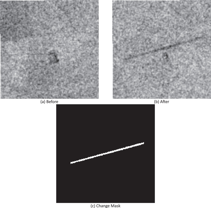 Figure 2
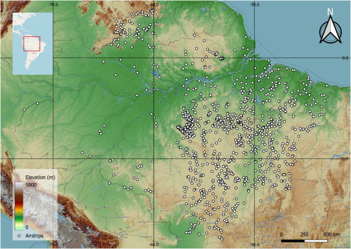 Figure 3
Peer Reviews
No public reviews on file for this paper yet. If you reviewed it on a platform where reviews are public (OpenReview, ICLR, NeurIPS, ICML), you can paste yours below so the community can read it here.
Videos
No videos yet. Explain this paper in a talk, walkthrough, or lecture? Add one.
Taxonomy
TopicsRemote-Sensing Image Classification · Synthetic Aperture Radar (SAR) Applications and Techniques · Automated Road and Building Extraction