SARCDNet-an enhanced deep learning network for change detection from bi-temporal SAR images
Vibha Damodara Kevala, Vishal Mukundan, Sravya Nedungatt, Shilpa Suresh, Shyam Lal

TL;DR
SARCDNet is a new deep learning model that improves change detection in SAR images, especially useful for monitoring floods and other environmental changes.
Contribution
SARCDNet introduces an adaptive fusion block with global filtering and channel attention for improved SAR change detection.
Findings
SARCDNet demonstrated a 4.26% improvement in F1 score for flood change detection.
The model achieved 4.92% improvement in κ and 4.67% in MCC on the Chao Lake dataset.
SARCDNet outperforms existing methods in handling speckle noise in SAR images.
Abstract
Change detection analysis is a crucial process in microwave remote sensing enabling the identification of changes on the Earth’s surface due to natural and human activities. Bi-temporal Synthetic Aperture Radar (SAR) imaging is particularly effective for flood detection, environmental monitoring, disaster response and urban planning due to its all-weather, day-and-night capabilities. Conventional optical imaging methods face challenges such as cloud cover and daylight dependency making SAR a preferred alternative. The availability of SAR data from satellite resources such as RADARSAT, Sentinel-1, Envisat has helped in advancing change detection analysis. This paper introduces SARCDNet (SAR Change Detection Network) model which is an enhanced deep learning network for change detection from bi-temporal SAR images. Adaptive fusion block is designed, which incorporates the adaptive global…
Genes, proteins, chemicals, diseases, species, mutations and cell lines named across the full text — each resolved to its canonical identifier and authoritative record.
Click any figure to enlarge with its caption.
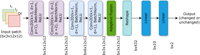 Figure 1
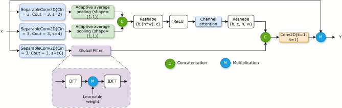 Figure 2
 Figure 3
 Figure 4
Peer Reviews
No public reviews on file for this paper yet. If you reviewed it on a platform where reviews are public (OpenReview, ICLR, NeurIPS, ICML), you can paste yours below so the community can read it here.
Videos
No videos yet. Explain this paper in a talk, walkthrough, or lecture? Add one.
Taxonomy
TopicsRemote-Sensing Image Classification · Flood Risk Assessment and Management · Remote Sensing and Land Use