Towards an optimized paradigm: generative adversarial networks and 3D modeling in landscape design and generation
Ming He

TL;DR
This paper introduces a new VR-based method for urban landscape design that uses 3D scanning and generative networks to reduce rendering time and improve visual quality.
Contribution
A novel urban landscape design method combining 3D laser scanning, adversarial generative networks, and texture mapping to enhance efficiency and visual fidelity.
Findings
The proposed method reduces rendering times by up to 90% compared to traditional tools.
It achieves significant improvements in visual fidelity as measured by standard image quality metrics.
Performance assessments across four scenarios validate the method's effectiveness in urban landscape simulations.
Abstract
Virtual reality (VR) integrates technologies like computer graphics, artificial intelligence, and multi-sensor systems, creating transformative tools for designers and users. This study proposes a novel urban landscape design method using 3D laser scanning combined with frame reorganization and texture mapping. Despite the advancements in VR-based landscape design, existing methods often suffer from inefficiencies in rendering time and suboptimal visual fidelity, limiting their practical application in large-scale urban projects. In the initial phase, we acquire the central pixel point of the images via a meticulous 3D scanning process, thus facilitating a three-dimensional stereo reorganization of urban architectural landscapes. This stage is succeeded by the application of a terahertz wave image segmentation strategy, grounded in the sophisticated utilization of adversarial generative…
Genes, proteins, chemicals, diseases, species, mutations and cell lines named across the full text — each resolved to its canonical identifier and authoritative record.
Click any figure to enlarge with its caption.
 Figure 1
 Figure 2
 Figure 3
 Figure 4
 Figure 5
 Figure 6
 Figure 7
 Figure 8
 Figure 9
 Figure 10
 Figure 11
 Figure 12
 Figure 13
 Figure 14
 Figure 15
 Figure 16
 Figure 17
 Figure 18
 Figure 19
 Figure 20
 Figure 21
 Figure 22
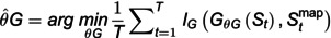 Figure 23
 Figure 24
 Figure 25
 Figure 26
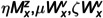 Figure 27
 Figure 28
 Figure 29
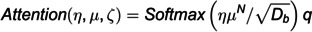 Figure 30
 Figure 31
 Figure 32
 Figure 33
 Figure 34
 Figure 35
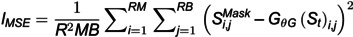 Figure 36
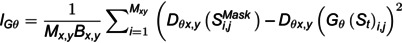 Figure 37
 Figure 38
 Figure 39
 Figure 40
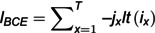 Figure 41
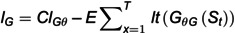 Figure 42
 Figure 43
 Figure 44
 Figure 45
 Figure 46
 Figure 47
 Figure 48
 Figure 49
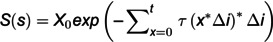 Figure 50
Peer Reviews
No public reviews on file for this paper yet. If you reviewed it on a platform where reviews are public (OpenReview, ICLR, NeurIPS, ICML), you can paste yours below so the community can read it here.
Videos
No videos yet. Explain this paper in a talk, walkthrough, or lecture? Add one.
Taxonomy
TopicsRemote Sensing and LiDAR Applications · Urban Green Space and Health · 3D Surveying and Cultural Heritage