Narrowing the gap for city building height predictions
C. Scott Watson, John R. Elliott

TL;DR
This paper shows how high-resolution satellite data can accurately predict building heights in cities of the Global South, helping with urban planning and sustainability.
Contribution
The study introduces a method using high-resolution digital elevation models and deep learning to estimate building heights in data-scarce regions.
Findings
Building heights were predicted with less than 1 meter mean absolute error using digital elevation models.
A deep learning model achieved 2.2–7.0 meter mean absolute error in predicting building heights from satellite imagery.
Google’s Open Buildings dataset improved predictions but tended to overestimate building heights in some cities.
Abstract
Understanding the 3D evolution of urban environments at high resolution through space and time is crucial for targeting sustainable development and enhancing resilience to hazards but usually requires expensive commercial satellite or aerial imagery. This leads to data scarcity and analytical biases in countries without access to these capabilities. Here we use high (1.5 m) resolution digital elevation models (DEMs) derived from satellite imagery to measure the vertical component of three cities in the Global South (Nairobi, Kathmandu and Quito), which we evaluate against published datasets of modelled heights. Building heights could be determined to < 1 m mean absolute error (MAE) using the DEMs, and 2.2–7.0 m MAE using a deep learning model trained to predict heights using high-resolution satellite imagery. Google’s Open Buildings 2.5D Temporal Dataset further improved on our deep…
Genes, proteins, chemicals, diseases, species, mutations and cell lines named across the full text — each resolved to its canonical identifier and authoritative record.
Click any figure to enlarge with its caption.
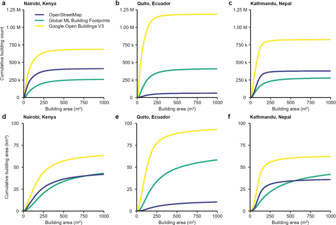 Figure 1
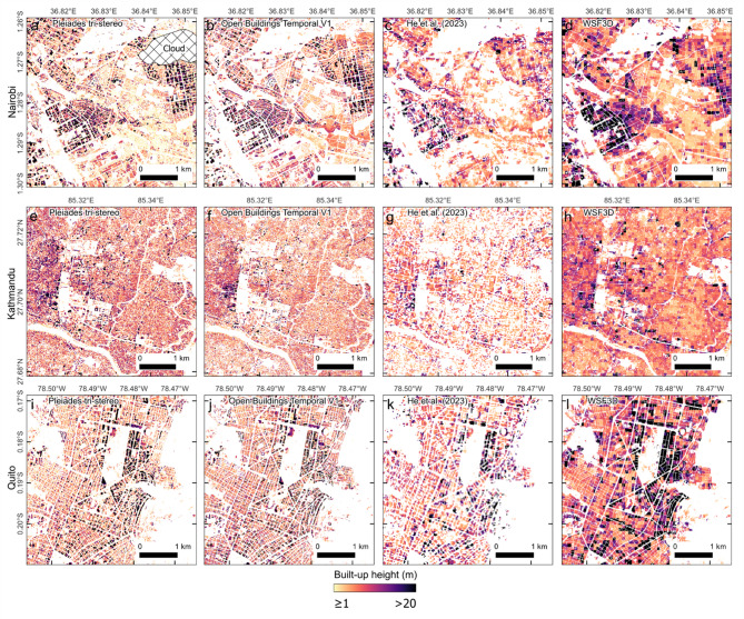 Figure 2
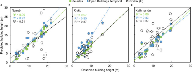 Figure 3
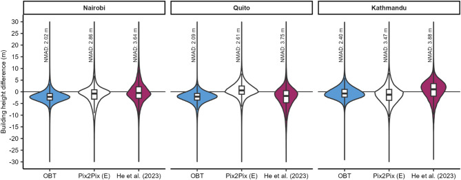 Figure 4
Peer Reviews
No public reviews on file for this paper yet. If you reviewed it on a platform where reviews are public (OpenReview, ICLR, NeurIPS, ICML), you can paste yours below so the community can read it here.
Videos
No videos yet. Explain this paper in a talk, walkthrough, or lecture? Add one.
Taxonomy
TopicsUrban Heat Island Mitigation · Wind and Air Flow Studies · Flood Risk Assessment and Management