Optical remote sensing for monitoring soil erosion in sub-Saharan grassland biomes: a systematic review
Nyasha Mubonderi, Alen Manyevere, Chuene Victor Mashamaite, Mohamed A. M. Abd Elbasit

TL;DR
This paper reviews how optical and radar satellite technologies can monitor soil erosion in sub-Saharan grasslands, highlighting gaps in research and validation.
Contribution
The study systematically evaluates remote sensing methods for soil erosion monitoring in sub-Saharan grasslands, identifying research gaps in SAR sensor applications.
Findings
Gully development is closely linked to topography, including river flow networks and slope gradients.
Optical remote sensing techniques are widely used, but SAR sensor effectiveness for erosion monitoring remains under-researched.
There is insufficient validation of SAR-derived erosion models with ground-truth data in the region.
Abstract
The Sub-Saharan African region is experiencing the effects of climate change and rapid population growth. The current population, together with the impacts of climate change, has a negative effect on soil resources; hence, implementing land conservation and sustainable land management methods is essential throughout the region. Policymakers require spatial information on soil erosion hotspots to make decisions because soil erosion has high negative impacts on agricultural lands. The study aimed to systematically review the literature on integrating optical and Synthetic Aperture Radar (SAR) systems and multiplatform satellite-based systems to monitor soil erosion in sub-Saharan grassland biomes. The review followed the PRISMA guidelines, and a bibliometric analysis was conducted to identify and evaluate relevant studies. In this study we include thirty-four articles for data extraction.…
Genes, proteins, chemicals, diseases, species, mutations and cell lines named across the full text — each resolved to its canonical identifier and authoritative record.
Click any figure to enlarge with its caption.
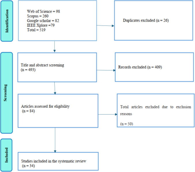 Figure 1
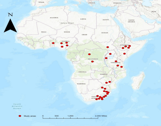 Figure 2
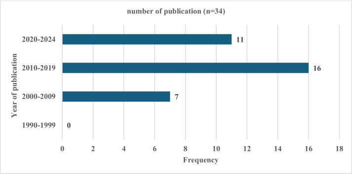 Figure 3
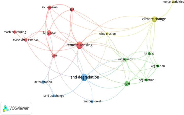 Figure 4
- —Govan Mbeki Research and Development Centre of the University of Fort Hare (South Africa)
- —Ecological Restoration of the Mistbelt forests
- —University of Fort Hare
Peer Reviews
No public reviews on file for this paper yet. If you reviewed it on a platform where reviews are public (OpenReview, ICLR, NeurIPS, ICML), you can paste yours below so the community can read it here.
Videos
No videos yet. Explain this paper in a talk, walkthrough, or lecture? Add one.
Taxonomy
TopicsSoil erosion and sediment transport · Aeolian processes and effects · Rangeland Management and Livestock Ecology
Introduction
Land degradation significantly affects grassland biomes and is recognized as a major global challenge in the twenty-first century, necessitating urgent mitigation efforts (Eswaran et al., 2019). It involves nutrient depletion, compaction, acidity, biodiversity loss, and soil erosion (Gomiero, 2016). The rapid changes in land use and the shift towards more intensive cropland management practices are primary causes of land degradation (Corbeels et al., 2020). Overgrazing, non-adoption of adequate conservation measures of soil, waterlogging, seasonal rainfall, floods, and drought are some accelerating factors contributing to land degradation. Land degradation also threatens global food security, and as such, sustainable ways to reduce it have been implemented (Gomiero, 2016). To reverse land degradation, the United Nations declared urgent action in 2012 (Kust et al., 2017). Subsequently, the United Nations introduced Sustainable Development Goal 15 of Life on Land, which focuses on “protecting, restoring, and promoting the sustainable use of terrestrial ecosystems; sustainably managing forests; combating desertification; and halting and reversing land degradation and biodiversity loss” (United Nations, 2020).
Soil erosion is a huge danger to world food supply. It affects water quality, crop yields, atmospheric carbon dioxide concentration, reservoir sedimentation, and hydrological regimes, including increased flood risk (Locatelli et al., 2022). Globally, Asia ranks first, followed by Africa, in the severity of soil erosion (Karamage et al., 2016). The main contributors to soil loss are strong winds, heavy rain, and surface runoff. Soil erosion due to water accounts for much soil loss, amongst other factors. Wang et al. (2021), found out that soil loss due to water was estimated to be 1150 t/km^2^ in 2003. Due to financial constraints, lack of awareness, and climate challenges, farmers in many developing nations fail to replenish appropriately lost soil nutrients, and this makes their land more susceptible to erosion (Benavidez et al., 2018).
Many factors influence soil erosion, including vegetation conditions, climate, hydrology, topography, and human influence (Corbeels, et al., 2020). Soil erosional rates in sub-Saharan Africa vary. In East African countries like Tanzania, drought is a commonly encountered phenomenon, and there is high-intensity livestock production, which lowers soil cover, reducing the stability of soil aggregate, and reduced infiltration rates, resulting in more soil loss (Blake et al., 2021). However, the south-eastern coast of Southern Africa receives high rainfall with high intensity, which results in high soil losses (Molekwa, 2013). Tully et al. (2015), reported an estimate of 280 million metric tons of soil loss per year for sub-Saharan Africa.
Grasslands are vital ecosystems that play crucial roles in biodiversity conservation, carbon sequestration, and supporting livelihoods across the sub-Saharan Africa region. However, monitoring and understanding the functions of these biomes, specifically in the wider perspective of environmental crisis and land use change, remains challenging. Grasslands are among the most prevalent ecosystem biomes, and they contribute approximately 40.7% of the world's terrestrial surface, along with forests (Soubry et al., 2021). Many ecosystem services are provided by grassland, which include the regulation of climate, cycling of nutrients, provision of forage material, and habitat (Bengtsson et al., 2019). According to Millennium Ecosystems Assessment, human activities also lower the capacity of the ecosystems, including grasslands, due to human-induced fires and population expansion (Liu et al., 2021; Millennium Ecosystem Assessment, 2005).
Given these impacts of soil erosion on the environment and agricultural lands, policymakers require spatial information on soil erosion for decision-making. Monitoring erosion by its spatial extent is significantly important for effective preventing and addressing erosion effectively. Precise soil maps that offer detailed information about soil properties and their geographic distribution are essential for good land management of resources, land suitability assessment, and land evaluation (Minasny & McBratney, 2008). Monitoring soil erosion also helps determine the amount of soil lost in each area.
Monitoring of soil erosion in ecosystems has been done using remote sensing and Geographical Information System (GIS) (Soubry et al., 2021). Remote sensing devices play an important role in collecting data on the available moisture in the soil, topography, climate variables, temperature, crop growth, and vegetation indices. These inputs are essential for estimating soil erosion rates indirectly; they are used to get the inputs for soil erosion models such as the Revised Universal Soil Loss Equation (RUSLE) and the Universal Soil Loss Equation (USLE) to estimate soil erosion. These sensors, which can be deployed on various platforms like drones and satellites, enable the precise measurement of key variables that are essential for monitoring agricultural and environmental conditions (Thorp & Tian, 2004). These tools can detect rangeland properties which include topography, surface roughness, landscape, bare soil coverage, and vegetation patterns. The GIS techniques are employed to analyze and manipulate geospatial data (Soubry et al., 2021). These GIS techniques are also useful in integrating data from different sources, such as satellite images, climate data, soil data, and socioeconomic data.
According to Garg et al. (2020), the global demand for a systematic global soil resource database is increasing due to the growing global challenges in land management. A systematic review on the integration of different remote sensing data, like fusing optical and synthetic aperture radar (SAR) data within a multiplatform satellite-based framework focusing on grassland biomes in Sub-Saharan Africa is crucial due to several significant gaps in current research. Due to the need for technical expertise and the lack of infrastructure for processing SAR data, most studies in sub-Saharan Africa have not integrated optical and SAR data, leaving a critical gap in achieving more accurate and timely assessments of soil erosion. By synthesising existing literature through a systematic review, this study aims to systematically review the literature on optical remote sensing for monitoring soil erosion in sub-Saharan grassland biomes. Moreover, the methodologies and techniques employed in the development of multiplatform satellite-based systems for monitoring soil erosion using remotely sensed data from diverse platforms in sub-Saharan African grasslands are assessed.
Methodology
This review employed a systematic mapping approach to gather and analyse existing scientific literature on the use of remote sensing techniques for monitoring soil erosion progression in degraded grasslands across sub-Saharan Africa. The systematic mapping approach was chosen to provide a comprehensive overview of the methods, technologies, and geographic distribution of studies, as well as to identify key research gaps in the monitoring of soil erosion using satellite based remote sensing. The study included all types of degraded grasslands, such as pasturelands, savannas, and rangelands, and examined soil erosion progression across various temporal scales, including annual, decadal, and long-term trends. The Preferred Reporting Items Systematic reviews and Meta-analyses (PRISMA) were used to establish the eligibility and the exclusion criteria in this study and for data abstraction and analysis. The systematic review was guided by PRISMA because it helps in assessing as much relevant and available scientific literature as possible in a defined time frame (Mengist et al., 2020). PRISMA demonstrates the quality of the systematic review, and it allows readers to evaluate the weaknesses and strengths of the review (Moher et al., 2010).
The Web of Science, Scopus, IEEE Xplore, and Google Scholar databases were searched for peer-reviewed journal articles published from 1990 to February 2024. Web of Science and Scopus provide comprehensive coverage of high-quality journals, IEEE Xplore includes numerous journals on technical advancements in remote sensing, and Google Scholar offers broader literature coverage. Hence, these databases were selected and used in this study to ensure a balanced and robust representation of soil erosion studies using remote sensing techniques. The year 1990 was selected as the starting point because it was a turning point when satellite-based remote sensing like Landsat and SPOT became widely used for environmental monitoring. Also, in 1990 there was an increase in global attention on land degradation, especially in sub-Saharan Africa, thus allowing this study to thoroughly examine how methods for studying soil erosion have evolved over the past three decades. The keywords combinations used in the Web of Science and Scopus databases are as follows: Soil degradation” OR Land degradation” AND “Soil erosion” OR"Soil loss” AND “sub-Saharan Africa” AND “Sustainable Development Goal’’ AND “Remote sensing” AND “Geographic Information System” AND “Synthetic Aperture Radar Systems” AND “Grassland biomes” OR “Land use” OR “Land practice” AND “Abiotic Factors” AND “Climatic Factors” AND “Topological Factors” AND “Control measures” OR “Control strategies” AND “Vegetation density” OR “Vegetation cover” AND “Sheet erosion” AND"Gully erosion” AND"RUSLE” AND"USLE” AND"Catchment area” AND"Aster data” AND"Land cover changes”.
Selection criteria
The systematic searching was done in stages. The initial stage was to identify key words that were obtained from previous studies on soil erosion monitoring. This was followed by a screening stage where duplicates were removed, and the eligibility and exclusion criteria were conducted. The articles included in the study concentrated on monitoring soil erosion using remote sensing methods. In grasslands and catchment regions, the application of soil erosion models for monitoring is linked to factors such as rainfall, wind, animal activities, and topography within the sub-Saharan African area. The studies used in this study were researched according to predefined selections summarized in Table 1 below. Table 1. Overview of the selection criteria applied in the studyCriterionInclusion CriteriaExclusion CriteriaArticle Type and LanguageAll articles, notes, survey papers, and conference papers written in EnglishAll articles, notes, survey papers, book chapters, and conference papers not written in EnglishCountries or RegionStudies conducted inside sub-Saharan Africa were includedStudies conducted outside sub-Saharan AfricaTimelineBetween 1990 and 2023 < 1990Study DesignStudies with adequate systematic approaches were includedStudies with inadequate systematic approaches were excludedMonitoring TechniqueAll studies include remote sensing techniquesAll studies that excluded remote sensing techniquesLand UseStudies conducted in grasslands and catchmentsAll studies that were not conducted in grasslands and catchmentsData QualityQualitative studies that are well reportedStudies with poor data quality were excludedPeer ReviewPeer reviewed articlesThe current study excludes non-peer reviewed articles
Data extraction
Articles were screened based on the time when the article was published, the study design used, the study region, peer review status and the quality of the data in the articles identified. The articles used in the review were all written in English, peer reviewed articles and these studies were conducted in grasslands and catchment areas within the sub-Saharan Africa region. After the screening process, the data was extracted from the included articles.
Data analysis
The results were presented in tables, and descriptive statistics were illustrated using bar graphs. For data management, Excel and Mendeley software were employed to acquire and store data from the databases, and duplicates were eliminated. The Mendeley software was used because it can import and arrange references, create bibliographies, organize sources using groups, tags, and filters, and allows the author to collaborate with others (Banat, 2021). A bibliometric analysis was conducted to identify emerging trends and key research themes, focusing on author keywords from documents that met the eligibility criteria. This approach provided insights into the most frequently studied topics, the evolution of research focus over time, and areas requiring further investigation in the field of soil erosion monitoring using remote sensing techniques. The VOSviewer version 1.6.16 was utilised to visualise the relationships and coherence among the authors'keywords.
Risk of bias assessment
The Crowe Critical Appraisal Tool was utilised to evaluate the review methodology, focusing on key criteria that include preliminaries, introduction, design, sampling, data collection, ethical considerations, results, and discussion and conclusion (Kadir Shahar et al., 2020).
Results and discussion
Study selection
The study identified 519 records from four databases, removed 26 duplicates, and reconstructed 403 records. The 84 articles qualified for full-text review, with 50 excluded due to exclusion reasons which include non-grasslands, pre-1990, or traditional methods. The 34 articles met the selection criteria. Figure 1 below illustrates the selection process used to identify studies for inclusion based on PRISMA guidelines.Fig. 1. Flow diagram of the selection process used to identify studies for inclusion based on Preferred Reporting Items Systematic reviews and Meta-analyses guideline. The letter n = number of articles
Geographic distribution and publication trends
This study included 14 studies conducted in South Africa, mainly in Eastern Cape, KwaZulu‒Natal and Limpopo, provinces. The other studies included were carried out in Zimbabwe (n = 2), Eastern Sudan (n = 1), Tanzania (n = 3), Kenya (n = 1) Rwanda (n = 1), Ethiopia (n = 4), Uganda (n = 1) Republic of Benin (n = 1), Democratic Republic of Congo (n = 2), and Nigeria (n = 4). Figure 2 shows how the studies included are frequently published. Figure 2 below shows the geographical distribution of the studies included in the systematic review.Fig. 2. The geographical distribution of the studies has been included in the systematic review
The study included no publications from 1990 to 1999 since none of the screened articles fit the inclusion criteria. As sub-Saharan African nations'technological capabilities improved between 2010 and 2019, more publications that employed the technology were published (Kulimushi et al., 2021a, 2021b). Compared with the articles from 2010 to 2019, there are fewer from 2020 to 2024 because the monitoring processes take time, methodological and technological adaptation delays, and COVID-19-related disruptions. Particularly in the present, there are noticeable gaps in the literature regarding remote sensing techniques, particularly multiplatform satellite-based systems for monitoring soil erosion in sub-Saharan African grassland biomes (Fig. 3).Fig. 3. The frequency of included studies published from 1990 to 2024 conducted within the sub-Saharan African region
Bibliometric analysis
Figure 4 shows a bibliometric analysis of the author keywords from the titles and abstracts of the articles qualified and eligible for review. The coherence of keywords, and the node size indicates the frequency of occurrence, and their co-occurrence is represented by the curves between nodes. If there is a short distance between two nodes, it means there is high coherence between the two words. Soil erosion is represented by five clusters, with 161 links and a total link strength of 99. This shows that soil erosion was strongly connected to several key topics such as remote sensing, land use change, land degradation and ecosystem services. Remote sensing has one cluster, with 15 links and a total strength of 24 with an occurrence of 29. It was primarily linked to topics like land cover, GIS, land degradation, ecosystem services, and soil erosion. The results indicate that remote sensing was commonly associated with technologies and methods to monitor and examine land degradation, grassland ecosystems, and the changes in land cover, and soil erosion studies. Remote sensing provides important spatial data on land cover changes, ecosystem health, and soil erosion patterns. Land use changes, such as agricultural expansion and deforestation, are significant drivers of soil erosion (Corbeels et al., 2020). These activities remove the protective vegetation cover that stabilises the soil, leading to reduced soil stability and increased susceptibility to erosion.Fig. 4A bibliometric analysis of the author keywords
General characteristics of the included studies
Multiplatform satellite-based methods were employed in the selected studies to monitor soil erosion progression in sub-Saharan grassland biomes. The GIS and soil loss models were also applied together to monitor the progression of soil erosion. All 14 included studies were conducted on a large scale within the sub-Saharan grassland biomes. Gullies are mainly dominant in the grassland biomes, and multispectral satellite-based images are highly utilised for monitoring gullies because they are more accurate and efficient than traditional methods (Elachi & Van Zyl, 2021). Multispectral satellite-based images have higher resolution, wider coverage, temporal monitoring capabilities, cost and time efficiency, and they have ability to identify non-visible features as compared to traditional. Only one study focuses much on landslide mapping (Odhiambo et al., 2019). Three selected studies focus on grasslands within the catchment areas (Mhangara et al., 2012; Muhoyi & Muhoyi, 2023; Nzuza et al., 2021).
Main findings
Use of multiplatform satellite-based in monitoring soil erosion
Table 2 illustrates the main findings for each of the articles included. The selected articles reported that the use of multiplatform satellite-based systems in monitoring soil erosion in sub-Saharan grassland biomes has increased from the early 2000 s to the present. However, they have some limitations which include cloud cover mainly in tropical regions, and in some areas, they are restricted to access higher resolution, and this hinders their effectiveness (Dzurume et al., 2022). The results from the selected articles showed that in monitoring soil erosion progression, multispectral Landsat series, Sentinel 2 satellite, Landsat 8, ASTER, SRTM, GIS, soil loss models, and field validation through field surveys are employed. The selected articles show that remote sensing techniques are highly efficient in mapping and monitoring soil erosion compared to traditional methods. Most satellite-based systems across multiple platforms provide a cost-free, convenient, and time-saving method for obtaining data on how eroded areas are spatial distributed (Reddy et al., 2018). Table 2. Application of different remote sensing methods to monitor land degradation in the grassland biomes of sub-Saharan AfricaReferenceStudy locationObjectiveRemote sensing technique usedMain findingsNzuza et al., 2021Sekhukhune District, South AfricaAssessing and mapping land degradation using a triangulation approachThe WOCAT mapping questionnaire and remote sensing techniquesDue to overgrazing low-lying areas were moderately degradedDube et al., 2017King Sabata Dalindyebo local municipality in Eastern Cape Province, South AfricaExamining the spatial and temporal variations of land degradation using Landsat series dataMultispectral LandsatThe Multispectral Landsat series dataset was highly efficient in monitoring the levels of land degradation catchmentsSepuru and Dube, 2018Sekhukhune rural district, Limpopo Province, South AfricaUnderstanding the spatial distribution of eroded areas by comparing evidence from two new noncommercial multispectral sensorsSentinel 2 and Landsat 8Raw spectral bands and vegetation indices combination derived from the used remote sensed data and notably enhanced the accuracy of detection and mapping at (α = 0.005)Muhoyi et al., 2023Manyame River, in ZimbabweExploring the potential of GIS and remote sensing in mapping land degradationNDVI and GIS techniques4.08% of the area was severely degraded, 19.80% is moderately eroded, 38.58% is severely degraded, and 37.54% of the area was not degradedNzuza et al., 2022South AfricaTo forecast land degradation by using Sentinel-2 data together with environmental variablesEnvironmental variables together with Sentinel-2The addition of multi-seasonal high-resolution Sentinel 2 data, environmental, spectral bands, and spectral vegetation indices enhanced the overall model accuracy for all scenariosSeutloali et al., 2016South AfricaAssessing gully erosion along the major armoured roadsRemote sensing and GIS approachThe volume of gullies strongly influenced the hill slope gradient and roadsTaruvinga, 2009South AfricaUse remote sensing to map gulliesTM-derived VI techniques, and SPOT 5 panchromatic imageryThe SVM classification technique was shown to be the most accurate way for mapping gullies using remote sensingLandsat TM showed the greatest potential to map gulliesDzurume et al., 2022Limpopo in South AfricaUsing multispectral satellite data to evaluate the effects of land management methods in wetlandsmulti-date Landsat imagesBetween 2014 and 2018, the Makuleke wetland's area decreased by 2%, while the Nylsvley wetland decreased by 3%Built-up areas increased marginally caused by the increase in the number of people and a rise in the development of infrastructureOdhiambo et al., 2019Makhado in Limpopo province of South AfricaMapping landslide prone areas using remote sensingAerial photographsThe actions of humans, precipitation destruction of forests, gullies, land use, slope, and increased agricultural activity all contributed to the landslides in Khalavha VillageMakaya et al., 2019South AfricaExamining the Sentinel-2 MSI sensor's ability to detect and map the spatial distribution of gullies within a community grazing environmentSentinel-2 MSI sensorThere was no significant difference that was observed between the environmental variables across the various estimated gully volumes, with a correlation between the variables (R = 0.190526)Watene et al., 2021KenyaThe study examines the spatial–temporal variability of future rainfall erosivity and its effects on soil lossRUSLE and CMIP5 models RCPEstimated soil erosion was “4.76 t ha^−1^ yr^−1”^The estimated increase in soil loss ranges from 29 to 60%Wickama et al., 2018TanzaniaTo Modell and map soil erosion in smallholder agro-ecosystemsRemote sensing, GIS and soil erosion modelling modelsThere were significant differences in soil conditions, vegetation cover, slope, and soil lossesIgbokwe, et al., 2008NigeriaTo map and monitor the impacts of gully erosionUSLE, Remote Sensing and GISThe developments of gullies were more pronounced in areas with high terrain undulationEl Haj Tahir, et al., 2010Blue Nile, Eastern SudanMapping soil erosion areasASTER imagery, SRTM and GISThe incision of gullies in the region was strongly linked to topography, particularly river flow networks and slopeMhangara et al., 2012Keiskamma catchment, South AfricaAssessing the risk of soil erosionGIS and remote sensingThe catchment experiences soil losses of 2576 t ha^−1^ yr^−1^ or higher, while 65% experiences low to moderate levels of soil lossÅrhem, & Fredén, 2014Mara region, TanzaniaEvaluating the effect of land cover change on soil erosionLandsat TM and ETM + images, RUSLEGiven rain fall kept average, soil erosion was influenced by land cover changesEmeribe et al., 2002University of Benin, located in Benin City, NigeriaEstimating annual amount of soil lossLandsat TM imagery, RUSLE coupled with GIS TechniqueThe study reveals a high annual rainfall-runoff erosivity value in the study area, with a low and uniform cover management factor throughout the Gulf siteChuma et al., 2023Democratic Republic of CongoMapping the susceptibility of Gully erosionMachine learning, Landsat 8, and ASTERThe occurrence of gullies was significantly influenced by factors such as NDVI, slope, distance to roads, distance to rivers, and Stream Power IndexKulimushi et al., 2021a, 2021bDemocratic Republic of CongoEvaluating the risk of soil erosionRUSLE, GIS and Sentinel-3 OLCI (2013–2019)Soil erosion was estimated to be “2.084 million tons”, and an average of 138.2t ha^−1^ yr^−1^Ewunetu et al., 2021Blue Nile RiverThe study employs a spatial multicriteria evaluation technique to map and assess the status of land degradationLandsat, ASTER Global Digital Elevation ModelSoil erosion and severe biological decline were vital indicators of land degradation in the study areaJiang, 2013Mount Elgon, UgandaGIS-based time series study soil erosion risk in a micro-catchmentASTER remotely sensed data, DMEs and RUSLEThere was less soil erosion in mountainous areasBalabathina et al., 2019Northwestern region of EthiopiaEstimating soil erosion using remote sensing and universal soil loss equationsLandsat-8 Imageries, GIS, and USLEThe soil loss in a year was 8, 43,736 tons. The average soil erosion rate was higher in the lower catchment. As compared to the upper catchment. The lower record 843 736 tons and the upper records 686 705Okenmuo & Ewemoje, 2023NigeriaUtilizing RUSLE, GIS, and remote sensing to estimate soil water erosionRUSLE, remote sensing, and GISSoil erosion is grouped as too low “55.1% < 20 ha^−1^ y^−^, low 31.3% 21–82 ha^−1^ y^−^, medium 9.4% 82–243 t ha^−1^ y^−^, high 3% 234–543 t ha^−1^; and extreme 1.2% > 543 t ha^−1^ y^−^”,Nambajimana et al., 2019RwandaAssess water erosion in Rwanda using different techniquesMODIS and ASTER GDEMTerracing can decrease soil loss from “14.6 t ha^−1^ y^−1^ to 11.7 t ha^−1^ y^−1”^Harmse et al., 2022South AfricaExamining various vegetation indices to quantify localised overgrazingSentinel-2 imageryRemotely sensed data is analysed spatially to give a comprehensive overview of livestock movement patterns on a landscape-scaleAzua et al., 2020NigeriaModelling of soil erosionLandsat 8 OLI, RUSLE, and GISThe factors that increase soil erosion in the area includes slope, low vegetation cover and high rainfallBouaziz et al., 2011EthiopiaUsing aster data and geomorphologic analysis to map gulliesSRTM and ASTER DEMThis quantitative analysis generates maps that enable the monitoring and mapping of land degradation due to gully-wideningTilahun et al., 2023EthiopiaTo evaluate the nexus between the dynamic of land use, land cover, and soil erosionLandsat imageriesSoil loss per year varied from 0 to 6953.23 ha^−1^ y^−1^ in 2020, with the highest levels observed in 1986, 1997, 2009, and 2020Vrieling et al., 2006TanzaniaEvaluating the spatial risk of soil erosionLandsat and SRTM DEMData such as SRTM DEM and Landsat images provide high-quality vegetation and topographic information, enabling quantitative results on spatial variation of soil lossLe Roux et al., 2008South AfricaPredicting soil erosion at national scaleMODIS-derived spectral index and RUSLEEastern Cape and KwaZulu-Natal Provinces had highest erosional potentials in South AfricaOkou et al., 2016Republic of BeninMapping soil erosion risk at a regional scale for decision supportASTER, MODIS, GIS, LANDSAT 7 ETM + imagesThe study indicated that the erosion risk is very low to low in 21.8%, medium in 58.5%, and high to very high in 19.5% of the study regionPhinzi et al., 2017Eastern Cape Province South AfricaApplying remote sensing to monitor soil erosionLandsat8 Operational Land ImagerSAVI achieved 83% classification accuracy and 64% kappa statistics, NDVI and SARVI got 81% accuracy and 60% and 59% kappa statistics, respectivelyDondofema et al., 2008Zhulube Meso-catchment of ZimbabweEvaluating the efficacy of GIS and remote sensing techniques in gully identificationLandsat TM imagery and GISGIS and remote sensing methods were utilized for gully identification, with accuracy varying based on the spatial, spectral, and temporal resolution of the imagerySeutloali et al., 2017The former South African homelands of TranskeiAssessing and mapping the severity of soil erosion30-m Landsat multispectral satellite dataApproximately 74% rill erosion occurred in the year 1984 and 54% in 2010. Soil erosion is accelerated by steeper areas, high stream power index, lower cover of vegetation, or a low topographic wetness index of below 5%WOCAT: World Overview Conservation Approaches and Technology, NDVI: Normalized difference vegetation index, GIS: Geographic Information Systems, SVN: The Support Vector Machine, VI: Vegetation Index, TM: Thematic Mapper, MSI: Multispectral Instrument, RUSLE: Revised Universal Soil Loss Equation, CMIP5: Coupled Model Intercomparison Project, RCP: Representative Concentration Pathway, t ha^−1^ yr^−1^: Tones per hectare per year, ASTER: Advanced Spaceborne Thermal Emission and Reflection Radiometer, SRTM: Shuttle Radar Topography Mission, DEM: Digital Elevation Model, TWI: Wetness Index, SPI: Stream Power Index
Spectral features (wavebands and vegetation indices)
Sepuru & Dube (2018), reported that Sentinel 2 MSI detected and mapped eroded regions with overall accuracy values slightly greater than those from Landsat 8 OLI. By integrating spectral vegetation indices with Sentinel-2 MSI spectrum reflectance information, classes of eroded surfaces were relatively well differentiated from other land cover types, and high precision in terms of ratios of OA, PA, and UA were achieved as compared to those from Landsat 8 OLI (Makaya et al., 2019). In the case of only extracted spectral data, Sentinel-2 MSI was slightly better than Landsat 8 OLI and produced similar results. The primary reason for this is due to Sentinel-2's higher spatial resolution of 10 m for visible and NIR bands compared to Landsat 8's 30 m, and its additional spectral bands, which enhance its ability to capture finer details and subtle variations in surface reflectance. Sentinel-2 MSI was outperformed by Landsat 8 OLI when spectral vegetation indices were applied or due to differences in band placement, spectral sensitivity. Overall, Sentinel-2 MSI outperformed Landsat 8 OLI, but the choice of sensor may depend on the specific application and analytical approach (Nzuza et al., 2021; Sepuru and Dube, 2018).
Advancement in remote sensing techniques in monitoring soil erosion: A South Africa case study
A total of 14 studies of 34 studies included in the systematic review were conducted in South Africa, indicating that the country dominates in remote sensing technique applications in monitoring soil erosion because of various factors, including the government funds to conduct environmental studies and data availability. The selected studies illustrated in Table 3 above include the study conducted using course-resolution Landsat 5 in 2009 to the use of Sentinel 2 higher resolution in 2022. This supports spectral capabilities, spatial resolution, and modelling accuracy increase as time increases. Soil erosion rates (t ha⁻^1^ y⁻^1^) were compared amongst these sensors to show how advancements in remote sensing have enhanced the detection and quantification of soil loss. However, from the observations, it was noted that SAR data in sub-Saharan Africa has not yet been employed to monitor soil erosion in grassland biomes. Nzuza et al. (2022), uses Google Earth Engine (GEE) because it has the potential to automate multi-temporal soil erosion assessment. Future researchers are recommended to GEE because it is used to handle huge data on a large scale. Also, SAR needs to be integrated to improve model scalability in the sub-Saharan region. Field observations were included in the table because they are used to validate the remote sensing outputs. The use of Landsat 5, which is an improved resolution, managed to capture moderate erosion estimated at 15–65 t ha⁻^1^ y⁻^1^. The use of higher resolution, which is Sentinel-2 MSI, and machine learning (Nzuza et al., 2022) used to estimate soil erosion rates of estimates (5–35 t ha⁻^1^ y⁻^1^). The use of Landsat managed to produce inputs used for RUSLE to predict gully and rill soil loss (Phinzi et al., 2017; Taruvinga, 2009.). The use of Sentinel-2’s spectral indices as inputs of soil erosion models and they were used to detect overgrazing. Table 3. Application optical remote sensing methods to monitor soil erosion: A South Africa case studyReferenceStudy locationSensor usedErosion rate (t ha^−1^ y^−1^)Field observationsRemote sensing key inputsErosion modelsGEETaruvinga, 2009KwaZulu NatalLandsat 5 (TM)Not quantifiedLarge gullies were visibleNDVINDVI and visual interpretationNot usedMhangara et al., 2012Keiskamma CatchmentLandsat 5(TM)5–50High erosion on steep slopes and bare soilNDVI, Slope (DEM), land coverRUSLE and GISNot usedPhinzi et al., 2017Eastern CapeLandsat 810–60Gully erosion correlated with slopeNDVI, Rainfall (R-factor), SlopeUSLENott usedSeutloali et al., 2017The former South African homelands of Transkei30-m Landsat multispectral satellite data15–70Severe erosion in degraded grasslandsNDVI, SBI Slope,RUSLENot usedHarmse et al., 2022South AfricaS entinel-2 (MSI)Not quantified (overgrazing severity classes)Overgrazing linked to erosion vulnerabilityNDVI, SAVI, EVIVegetation Index ThresholdsNot usedNzuza et al., 2022Greater Sekhukhune DistrictSentinel-2 (MSI)Predicted risk classesLand degradation hotspots were identifiedNDVI, SAVI, Spectral Indices (BSI, CI)Machine Learning (RF), NDVI SAVIGEE was usedTM: Thematic Mapper, OLI: Operational Land Imager, MSI: Multispectral Instrument, NDVI: Normalized Difference Vegetation Index, SAVI: Soil-Adjusted Vegetation Index, BSI: Bare Soil Index, CI: Clay Index, TPI: Topographic Position Index, DEM: Digital Elevation Model, USLE: Universal Soil Loss Equation, RUSLE: Revised Universal Soil Loss Equation, ML: Machine Learning, RF: Random Forest, GEE: Google Earth Engine, DEM: Digital elevation model, SBI: Soil Brightness Index, EVI: Enhanced Vegetation Index
Earth observation sensors
El Haj Tahir et al. (2010), reported out that STER-derived DEMs in Eastern Sudan's Blue Nile are less accurate than SRT due to low optical contrast in rural areas, shows the increase in the application use of remote sensing. The transition from traditional monitoring methods to aerial images and satellite-borne sensors has significantly improved the grassland biome research community. MODIS was launched in 2000 and resulted in an increase in remote field sensing, hence increasing the frequency of publications on monitoring soil erosion in grassland occurring in the 2000 s (Makaya et al., 2019; Sepuru and Dube, 2018). The launch of Sentinel 2 MSI and Landsat 8 OLI in the twentieth century increased the number of publications on monitoring soil erosion because they offered free access to data. Numerous studies explore the use of SAR sensors to estimate soil erosion progression in grassland biomes, favoured by researchers for its ability to select suitable wavelengths (Rawat et al., 2016).
Gully and landslides development in grassland biomes
Studies on gullies were primarily conducted in Limpopo, the Eastern Cape, and KwaZulu-Natal Province (Dube et al., 2017; Le Roux et al., 2008; Nzuza et al., 2021; Odhiambo et al., 2019; Sepuru and Dube, 2018). Numerous studies have been conducted in these provinces, and this highlights the significance of gullies as a key focus of research in the areas. Overgrazing contributes to soil loss in grassland biomes as shown in Table 2 (Nzuza et al., 2021). However, gully developments are more pronounced in areas with high terrain undulation. Gully incisions are linked to topography, particularly river flow networks and slopes, and climate change. These can trigger new processes due to increased rainfall or weakened land cover. The selected articles also report that most grasslands were moderately eroded. The reports included in the study recommend monitoring erosion and implementing sustainable practices to reduce soil loss.
Furthermore, the findings indicated that the development of gullies in grasslands varies because of different factors, which include vegetation density, slope, climate, and TWI. In support of that, one of the included studies reports “no significant difference between the environmental variables across the different estimated gully volumes and indicates a weak correlation between the variables of R = 0.19” (Makaya et al., 2019). The findings show that gully developments occur on gentle slopes of approximately 7^0^ (Makaya et al., 2019). Field observations were used in selected studies to validate the conclusions from remote sensing. Gully-prone areas are often linked to convergence zones with concave platform curvature, triggering gullies due to increased runoff volume downslope (Phinzi & Ngetar, 2017).
The reports indicated that population growth accelerates the depletion of environmental resources, leading to higher deforestation rates, which in turn increases landslide activity in mountainous areas and causes soil erosion in grassland biomes (Odhiambo et al., 2019). In grasslands, landslides are due to slope saturation by water. The water effect is a result of intense rainfall, groundwater levels, and changes along coastlines, earth dams, and riverbanks (Popescu, 2002).
Variation in the rate of soil erosion in different agro-ecosystems
In Kenya, the estimated soil loss was 4.76 t ha^−1^ yr^−1^, expected to rise by 29–60% (Watene et al., 2021). The factors causing an increase in soil loss include climate change, drought, illegal logging, aggressive agricultural practices, and cattle overgrazing. Report by Watene et al. (2021), indicated that natural forests have less soil loss of “1.57 t ha^−1^ yr^−1”^, and croplands are highly degraded agro-ecosystems because of uncovered soils from poor conservation and cultivation methods and practices. Croplands’ topsoil is exposed in off-seasons and often blown away by wind or rain. Dense forest plants keep soil bound in locks of roots, thus preventing erosion. In Kenya, agro-ecological ecosystems showed “significant differences (p < 0.05) in terms of soil” conditions, vegetation cover, slope, and soil losses (Watene et al., 2021).
Limitations of the study
- In sub-Saharan Africa, some countries use French, Portuguese, or other languages to write their research findings. This poses a challenge when conducting the literature search since the current study only included English articles.
- Some articles were not accessible, and some were unavailable at total length due to limited institutional subscription, pay walls and restricted access. For the above reasons, it was difficult to quantify all the studies on integrating optical and SAR systems in monitoring soil erosion in sub-Saharan grassland biomes.
- Selection bias in studies can lead to incorrect evidence. PRISMA reduces this by using multiple databases, languages, and grey literature sources, and publishing search methods in a priori protocol for peer review.
- Lack of transparency or reliability is one of the limitations that were encountered. However, the authors employed PRISMA to be explicit and to maintain the quality and standard of the systematic review.
Research gaps and future study recommendations
- Monitoring the progression of soil erosion in sub-Saharan African grassland biomes is necessary. Considerable gaps exist worldwide, specifically on the African continent, in integrating remote sensing techniques to monitor and map soil erosion progression.
- Application of multiplatform satellite-based systems in monitoring soil erosion in sub-Saharan Africa has yet to attract significant attention in many countries within the sub-Saharan Africa.
- Future researchers in sub-Saharan Africa should use remote sensing-based vegetation indices like modified NDVI, NDSI, and TCT to estimate soil erosion, as they are commonly used in developed countries.
Conclusion
This study systematically reviewed the literature on integrating optical and SAR systems, as well as multiplatform satellite-based systems, for monitoring soil erosion in sub-Saharan grassland biomes. Through evaluation of advancements and identification of research gaps, the study highlights the growing role of remote sensing technologies in addressing soil erosion challenges. The review of 34 articles revealed that most studies were conducted in South Africa on the application of multiplatform satellite-based systems for soil erosion monitoring. The application of multiplatform satellite-based systems for monitoring and mapping soil erosion progression has yet to attract some countries within sub-Saharan Africa. Remote sensing techniques mainly employed in monitoring and mapping soil erosion include multispectral Landsat series, Sentinel 2 satellite, Landsat 8, ASTER, and SRTM. These techniques are highly efficient in mapping and monitoring soil erosion compared to traditional methods. For large-scale monitoring of soil erosion, remote sensing is highly effective because it provides extensive spatial coverage, and it can track changes over time. For small-scale studies, field measurements are essential as they offer highly accurate, localized data that can capture site-specific details. By combining these approaches, more accurate and reliable results can be produced. The use of multispectral and SAR data, particularly in combination, has the potential to provide more comprehensive and timely assessments of soil erosion, especially in cloud-prone areas where optical data alone is insufficient. However, the integration of optical and SAR data remains underexplored, representing a critical gap in current research. The study found that gully developments are more pronounced in high terrain undulation areas, strongly associated with topography, and suggests using remote sensing-based vegetation indices for soil erosion estimation.
The reference list from the paper itself. Each links out to its DOI / PubMed record.
- 1Århem, K. & Fredén, F. (2014). Land cover change and its influence on soil erosion in the Mara region, Tanzania: Using satellite remote sensing and the Revised Universal Soil Loss Equation (RUSLE) to map land degradation between 1986 and 2013. Student thesis series INES. Available at: http://lup.lub.lu.se/student-papers/record/5157972. Accessed 15 Mar 2024.
- 2Elachi, C. & Van Zyl, J.J. (2021). Introduction to the Physics and Techniques of Remote Sensing. John Wiley & Sons. Available at: https://books.google.com/books?hl=en&lr=&id=B 1Qm EAAAQBAJ&oi=fnd&pg=PP 1&dq=Elachi,+C.+%26+Van+Zyl,+J.J.+(2021).+Introduction+to+the+Physics+and+Techniques+of+Remote+Sensing.+John+Wiley+%26+Sons&ots=d Ojr 3H_H 3Z&sig=CA Lab PK Cekzv Sz_T 5H Uj 4AR 515. Accessed 15 Feb 202I.
- 3Emeribe, C.N., Isagba, E.S., Iwhiwhu, B.E., Ogbomida, E.T. & Akukwe, T.I. (2022). Estimating Annual Amount of Soil Loss Over University of Benin Using RUSLE, GIS and Remote Sensing Methods. NIPES-Journal of Science and Technology Research, 4(1). 10.37933/nipes/4.1.2022.2
- 4Jiang, B. (2013). GIS-based time series study of soil erosion risk using the Revised Universal Soil Loss Equation (RUSLE) model in a micro-catchment on Mount Elgon, Uganda. Student thesis series INES. Available at: http://lup.lub.lu.se/student-papers/record/4076063. Accessed 15 Mar 2024.
- 5Millennium Ecosystem Assessment. (2005). Ecosystems and Human Well-Being: Biodiversity Synthesis. World Resources Institute.
- 6Minasny, B., & Mc Bratney, A. B. (2008). Quantitative models for pedogenesis—a review. Geoderma, 144(1–2), 140–157. 10.1016/j.geoderma.2007.12.013
- 7Molekwa, S. (2013). Cut-off lows over South Africa and their contribution to the total rainfall of the Eastern Cape Province. Ph D dissertation. University of Pretoria, South Africa. 10.1007/s 00382-012-1579-6
- 8Odhiambo, B.D.O., Kataka, M.O. & Mashudu, M. (2019). The use of remote sensing to map landslide prone areas in Makhado Municipality of Limpopo Province, South Africa. Accessed at: https://www.unisdr.org/files/65868_f 222odhiambolandslidessouthafrica%5B 1%5D.pdf. Accessed 6 Feb 2024.