Attain: Inclusive annotated pavement distress types and severity dataset
Mohammad Rezaeimanesh, Amir Golroo, Mohammad Sadegh Fahmani, Mohammad Javad Amani, Farid Hasanitabaar, Mohammad Saleh Entezari, Sane Karimi

TL;DR
The Attain dataset provides annotated pavement distress images to help develop machine learning models for road maintenance decisions.
Contribution
Introduces a diverse, smartphone-collected pavement distress dataset with expert annotations and severity levels.
Findings
The dataset includes 2293 images annotated with 10 pavement distress types and three severity levels.
Images were collected using smartphones, reducing data collection costs while maintaining quality.
The dataset supports robust model training for automated pavement distress detection and classification.
Abstract
Pavement distress detection plays a crucial role in pavement management and rehabilitation (M&R) by providing essential data for maintenance decision-making. The Attain dataset is introduced to facilitate the development of machine learning and deep learning models for pavement distress classification and object detection. The dataset consists of 2293 images collected using three smartphones mounted on vehicle windshields. All photos are manually annotated by pavement engineer experts. The images capture a variety of pavement conditions under different lighting and traffic scenarios, making the dataset diverse and suitable for training robust models. The dataset encompasses ten distinct pavement distress categories including alligator cracks, block cracks, longitudinal and transverse (linear) cracks, faded marking, lane/shoulder drop-off, patch and utility cut, potholes, manhole,…
Click any figure to enlarge with its caption.
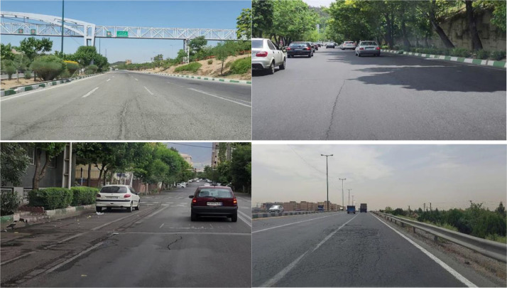 Figure 1
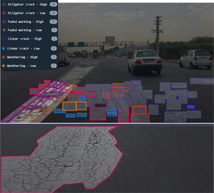 Figure 2
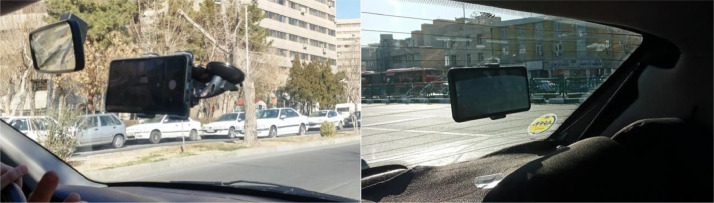 Figure 3
Peer Reviews
No public reviews on file for this paper yet. If you reviewed it on a platform where reviews are public (OpenReview, ICLR, NeurIPS, ICML), you can paste yours below so the community can read it here.
Videos
No videos yet. Explain this paper in a talk, walkthrough, or lecture? Add one.
Taxonomy
TopicsInfrastructure Maintenance and Monitoring · Asphalt Pavement Performance Evaluation · Underground infrastructure and sustainability
Specifications TableSubjectEngineering & Materials scienceSpecific subject areaPavement Distress Detection and ClassificationType of dataRGB Images (.jpg), Annotation Files (.xml and .txt)Data collectionThe data were collected using three Samsung smartphones: Galaxy A72 (19201080), Galaxy S20 FE (38402160), and Galaxy S22 (38402160). These smartphones were mounted and fixed on the windshields of a vehicle using two phone holders. The vehicle traveled at speeds in the range of 20 to 70 km/h while the smartphone cameras were recording videos of the pavement surface. A total of 20 hours of video recordings were then used to extract images of pavement distresses. The dataset contains images with resolutions of either 640640 or 1479*508 pixels and covers ten different pavement distress types with their severity.Data source locationTehran, IranData accessibilityRepository name: AttainData identification number: 10.17632/nykrzdm74f.1Direct URL to data: https://data.mendeley.com/datasets/nykrzdm74f/1Related research article
Value of the Data
1
- •All images in the Attain pavement distress dataset were captured using smartphones mounted on the front and rear windshields and each smartphone was stabilized by two phone holders.
- •Images were taken by three different models of Samsung smartphones, Galaxy A72, S20 FE, and Galaxy S22. This variety can provide machine learning and deep learning models with images of different qualities and enhance their generalizability.
- •The Attain dataset encompasses various challenges in pavement distress detection, including stains on the road surface, different lighting, and traffic conditions. It also covers different functional classifications of roads, such as local roads and highways.
- •Images in the Attain dataset were captured while the vehicles’ velocity was in the range of 20 to 70 km/h, to further enhance the variety of data and improve the robustness of the models trained on this dataset.
- •The Attain dataset comprises ten different pavement distress types, longitudinal and transverse cracks (linear cracks), alligator cracks, block cracks, weathering, lane/shoulder drop-off, raveling, patching and utility cuts, manholes, faded markings, and potholes.
- •The cost of data collection was significantly reduced by utilizing widely accessible and conventional technologies.
- •The Attain dataset is designed to support diverse machine learning tasks, such as object detection and multi-class classification. This dataset can be used to benchmark models like YOLO, Faster R-CNN, or Resnet to localize and classify pavement distress types. Additionally, we have obtained classification accuracy benchmarks from sample models (e.g., YOLO) used in our study, which achieved mAP values above 0.92 for alligator cracking detection. These results demonstrate the practical utility of our method for road agencies aiming to automate pavement condition evaluation with minimal infrastructure investment.
Background
2
Pavement management and rehabilitation (M&R) is a crucial and budget-intensive component of pavement management systems. Pavement distress detection can help corresponding agencies in assessing pavement quality across road networks. However, the traditional process of data collection for M&R purposes requires significant manpower, financial investment, and technological resources, and is prone to human error [1].
Therefore, automating pavement distress detection and classification can alleviate financial burdens on pavement management agencies and minimize human errors. Researchers employ machine learning and deep learning methods to detect various pavement distresses from road surface images [[2], [3], [4]]. The Attain dataset has been developed to provide high-quality images for training machine learning and deep learning models with the purpose of accurate and efficient classification and object detection of pavement distresses.
Data Description
3
The Attain pavement distress dataset introduced in this study includes ten categories of pavement distress: longitudinal and transverse cracks (linear cracks), alligator cracks, block cracks, weathering, lane/shoulder drop-off, manholes, faded markings, raveling, patching and utility cuts, and potholes. Example images from the dataset are shown in Fig. 1. The different lighting and traffic conditions included in the dataset are demonstrated in this figure.Fig. 1. Example images of the Attain dataset.Fig 1
The Attain dataset contains a total of 2,293 images, distributed in three separate repositories: Attain_SMP_OS_v1.0, Attain_SMP_WS_v1.0, and Attain_SMP_WS_v2.0. Details regarding the number of images and distress types in each repository are presented in Table 1, Table 2. As shown in Table 2, there are a total of 19,761 instances of pavement distress in the Attain dataset. Two examples of annotated images with the purpose of object detection and classification are illustrated in Fig. 2.Table 1. Image and label characteristics of the Attain dataset.Table 1. Folder NameNo. of ImagesImage SizeAnnotationAnnotation FormatOS_v1.0637640640Object detection ClassificationText-based (Polygon Annotation Format)WS_v1.0809640640Object detection ClassificationText-based (YOLO)WS_v2.0847640640 1479508Object detection ClassificationXML-based (Pascal VOC)Table 2. Number of instances of each distress in the Attain dataset.Table 2. Distress TypeAlligator CrackLinear CrackBlock CrackFaded MarkingLane/ Shoulder Drop-offManholePatchingPotholeRavelingWeatheringOS_v1.0198720--------WS_v1.013494103394-50412921020721WS_v2.027044196581363348-7463153401640Total425190196114573485048755253602361Fig. 2Example annotations of Attain dataset images.Fig 2
Experimental Design, Materials and Methods
4
Images in this dataset were captured using three different Samsung smartphones. The specifications of these smartphone cameras are presented in Table 3. As shown in Fig. 3, the smartphones were mounted and fixed on the front and rear windshields inside the vehicle using two phone holders to minimize camera shaking avoiding blurred images. As the smartphones were installed, a driver started driving the car on urban roads with various functional classifications while the cameras were recording a continuous video of the road surface. The smartphones were slightly tilted downward to capture as much of the pavement surface as possible while avoiding capturing any part of the vehicle.Table 3. Camera specifications.Table 3. SmartphoneResolutionFocal LengthSensor SizePhase Detection Auto FocusOptical Image StabilizationGalaxy A721920108026 mm1/1.7”YesYesGalaxy S20 FE3840216026 mm1/1.76”YesYesGalaxy S223840*216024 mm1/1.56”YesYesFig. 3Smartphone setup on the front and rear windshields.Fig 3
The data collection was conducted in Tehran, Iran, where approximately 20 hours of video footage was recorded. During data collection, the speed of the vehicle was in the range of 20–70 km/h. To extract images from these recordings, frames were captured every 250 ms. A total of 2293 images were selected for labeling based on image quality and pavement visibility. Due to the high camera resolutions, these images were then resized to 640640 and 1479508 pixels. The dataset includes images taken under different lighting and traffic conditions to better simulate real-world scenarios.
Limitations
The dataset was collected in a single city (Tehran, Iran), which may limit its generalizability to other regions with different pavement conditions and climate factors. Additionally, only three Samsung smartphone models were used for data collection, which may introduce biases related to camera quality and sensor characteristics. Although various lighting and traffic conditions are included, extreme weather conditions such as heavy rain, snow, and fog were not considered. Furthermore, only ten pavement distress types were captured in this dataset with one sensor type which was a smartphone camera. The future work would be collecting all 20 asphalt distress types introduced by ASTM D 6433 [5] using a multi-modal approach via using other types of cameras i.e., active camera, stereo-vision camera, 360 camera, drone camera, and LIDAR.
Ethics Statement
We, the authors of this work, hereby declare that we have thoroughly reviewed and complied with all ethical standards required for publication in Data in Brief. We also confirm that this research does not involve human participants, animal testing, or the use of any data obtained from social media platforms. Our study adheres to all ethical guidelines and safeguards, ensuring the responsible and ethical execution of this research.
CRediT Author Statement
Mohammad Rezaeimanesh: Data Curation, Writing - Original Draft; Amir Golroo: Methodology, Conceptualization, Supervision, Validation, Writing - Review & Editing; Mohammad Sadegh Fahmani: Data Curation; Mohammad Javad Amani: Investigation; Farid Hasanitabaar: Data Curation, Investigation; Mohammad Saleh Entezari: Data Curation, Investigation; Sane Karimi: Data Curation, Investigation.
The reference list from the paper itself. Each links out to its DOI / PubMed record.
- 1Maeda H.Sekimoto Y.Seto T.Kashiyama T.Omata H.Road damage detection and classification using deep neural networks with smartphone images: road damage detection and classification Comput. Civil Infrastruct. Eng.33201811271141
- 2Hsieh Y.-A.Tsai Y.J.Machine learning for crack detection: review and model performance comparison J. Comput. Civil Eng.345202004020038
- 3Wenming C.Qifan L.He Z.Review of pavement defect detection methods IEEE Access 820201453114544
- 4Sholevar N.Golroo A.Roghani Esfahani S.Machine learning techniques for pavement condition evaluation Automat. Constr.1362022104190
- 5ASTM D 6433-20, “ASTM D 6433 - 20 Standard Practice for Roads and Parking Lots Pavement Condition Index Surveys,” ASTM International. Accessed: Sep. 19, 2021. [Online]. Available: https://www.astm.org/Standards/D 6433.htm