A dataset on forest stand structures, deadwood, and tree-related microhabitats along an urban-periurban gradient in Central Italy
Costanza Borghi, Soraya Versace, Elena Di Pirro, Davide Travaglini, Gherardo Chirici, Bruno Lasserre, Marco Marchetti, Giovanni D’Amico, Elia Vangi, Saverio Francini, Marco Montella, Giovanni Santopuoli, Marco Ottaviano, Francesco Parisi

TL;DR
This paper introduces a dataset of urban forest structures and microhabitats across three Italian cities, offering insights for ecological research and management.
Contribution
The novel contribution is a georeferenced dataset capturing forest structures, deadwood, and microhabitats along an urban-periurban gradient in Italy.
Findings
Three datasets were created from 180 plots across 12 urban parks in Florence, Rome, and Campobasso.
The datasets include tree-level microhabitats, dendrometric variables, and deadwood categories like snags and stumps.
The data can support future ecological analyses and urban forest management strategies.
Abstract
This database provides accessible and georeferenced information on forest structure, tree-related microhabitats, and deadwood of 12 urban forests located in 12 different urban parks across three Italian cities, Florence, Rome, and Campobasso. Four urban parks – varying in size, forest type, and history – were selected following an urban-periurban gradient in each city. Inner city parks are typically ancient, with native and non-native trees planted for aesthetic and cultural purposes, and scarce semi-natural vegetation remains. Periurban parks usually host native and semi-natural vegetation and may include agricultural areas. 15 plots were placed to survey a selected urban forest located in each of the 12 urban parks, using a systematic aligned sampling scheme and then visited in the field, for a total of 180 plots. The collected data contributed to the construction of three different…
Genes, proteins, chemicals, diseases, species, mutations and cell lines named across the full text — each resolved to its canonical identifier and authoritative record.
Click any figure to enlarge with its caption.
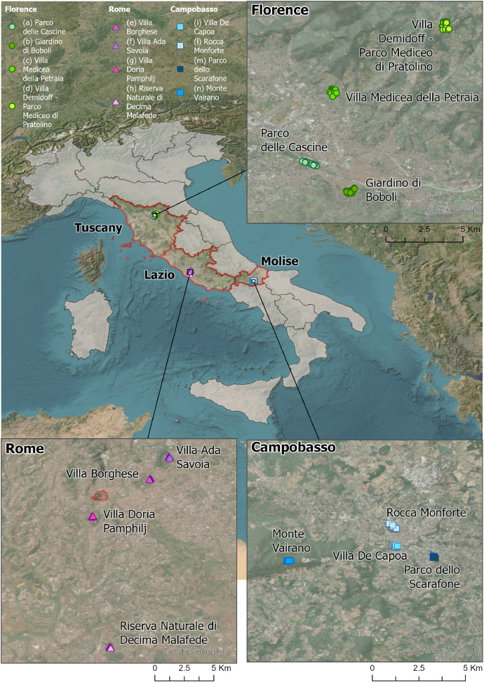 Figure 1
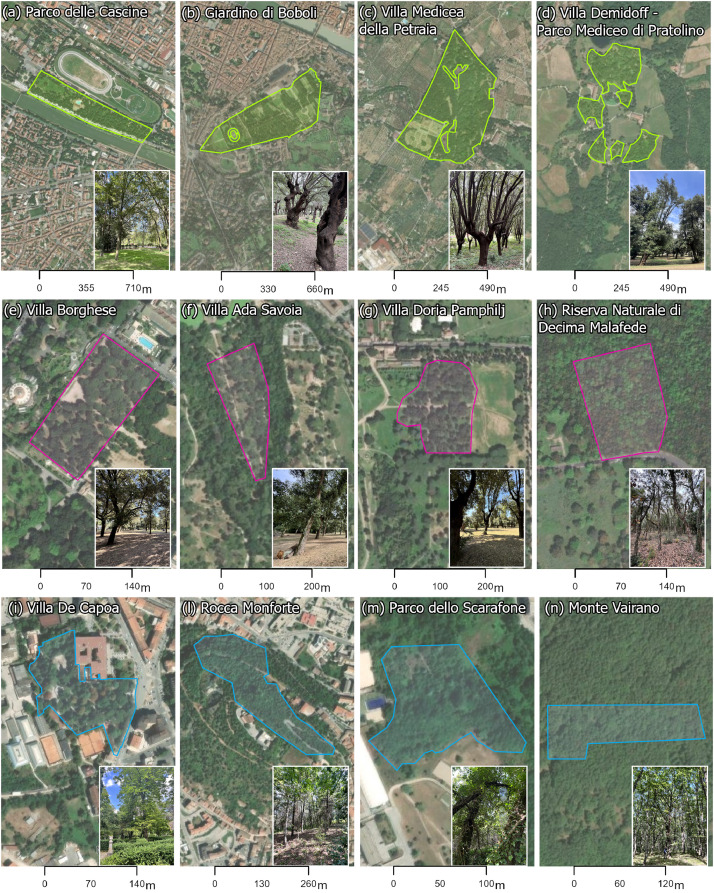 Figure 2
Peer Reviews
No public reviews on file for this paper yet. If you reviewed it on a platform where reviews are public (OpenReview, ICLR, NeurIPS, ICML), you can paste yours below so the community can read it here.
Videos
No videos yet. Explain this paper in a talk, walkthrough, or lecture? Add one.
Taxonomy
TopicsForest Ecology and Biodiversity Studies · Archaeological Research and Protection · Forest Management and Policy
Specifications TableSubjectEarth and Environmental SciencesSpecific subject areaDendrometric measurement; living trees, deadwood, and tree-related microhabitats surveyType of dataTable, Georeferenced dataRaw, AnalyzedData collectionDatasets are based on in-situ measurements conducted within 180 circular sample plots, each with a radius of 13 meters. Plots were distributed across twelve urban and periurban forests and parks (four for each location, spanning a gradient from urban to periurban environments) in three Italian urban areas: Florence, Rome, and Campobasso (Table 1). The data collection focused on living trees, deadwood, and tree-related microhabitats, following standardized sampling protocols. The instruments used for data acquisition included a tree calliper, GNSS, hypsometric equipments and an ultrasonic meter (i.e, Vertex).Data source locationThree Italian Municipalities (NUTS3 level): Florence, Rome, CampobassoData accessibilityRepository name: FigshareData identification number: 10.6084/m9.figshare.28450643Direct URL to data: https://figshare.com/articles/dataset/Urban_and_Periurban_Forests_of_Italy_Structure_Tree-related_Microhabitats_and_Deadwood/28450643
Value of the Data
1
- •Dataset can be used to assess broadleaves forest stand structures and microhabitat typologies along an urban-periurban gradient across different urban contexts.
- •Collected data contributes to increasing knowledge about deadwood and microhabitats as ecological indicators, usually scarcely addressed in urban environments.
- •Data can be employed to build a more comprehensive dataset including multiple cities from different climatic zones and forest types.
- •Locations and data can be related to landscape and context analysis to guide management actions on urban biodiversity.
- •Collected data can be integrated with an investigation on multi-taxon communities to evaluate their state-of-the-art in urban contexts.
- •Data can be combined with other sources of data including remotely sensed data to build new models and to improve urban green areas and biodiversity monitoring.
Background
2
Thanks to their proven capacity to provide ecosystem services, urban forests and trees are increasingly assessed, implemented, and maintained across different urban contexts [4]. Despite their role in contributing to climate regulation, air and water quality, and recreation and cultural activities being largely evaluated and discussed in the literature, their capacity to support biodiversity is still little known. Tree-related microhabitats and deadwood are two critical ecological indicators frequently employed in forestry studies to estimate species abundance and richness [18]. In natural forests, the limitation of deadwood resources can alter or threaten biodiversity, as its various forms and stages of decay are important for organisms’ existence (e.g., saproxylic beetles, [2]) and provide diverse ecosystems' functions [6]. Furthermore, different studies [16] showed evidence of the relationship between forest stand structure, management, and biodiversity support service. However, research expanding this methodological approach and data collection to the urban environment is still scarce in the literature. This dataset wants to contribute to filling this knowledge gap.
Data Description
3
This article describes the database of the linked repository of “Urban and Periurban Forests of Italy: Structure, Tree-related Microhabitats, and Deadwood” [1], showing data collected between 2022 and 2025 across 12 different urban forests as portions of respective 12 urban parks in three Italian urban areas, Florence, Rome, and Campobasso (Fig. 1). Coordinates and locations are provided in Table 1 and refer to the centroid of the urban forest (WGS-84 reference system), while specific locations of the 15 sampling plots within the surveyed forests will be made available on request.Fig. 1180 sampled plots placed to survey urban forests in each of the 12 urban parks across the three urban areas and related administrative regions, Florence (Tuscany region), Rome (Lazio region) and Campobasso (Molise region).Fig 1
Specifically, eight different files are provided in the repository, (i) the metadata (in xlsx format), (ii-iii) two tree-level datasets (the former regarding the plot structure, the latter tree-related microhabitat, both in xlsx format), (iv) and a deadwood dataset (related to five categories of deadwood, reported and divided into 5 sheets, in xlsx format), and (v) the georeferenced centroids of the sampled urban forests (WGS84 reference system, gpkg format), whose attributes are available in Table 1. Moreover, for each dataset (i.e., forest structure, tree-related microhabitats, and deadwood) an R code for basic elaborations and graphs’ creation was provided (R v. 4.4.3). The two tree-level datasets are organized into 4508 rows and 12 columns and 4148 rows and 72 columns, respectively. In the tree-level datasets, the rows represent the instances, and the columns represent the information collected for each tree. Table 2 shows an example of the first dataset providing the information on location, tree species, and forest structure (i.e., tree species, diameter at breast height, tree height, height-to-base of live crown, tree volume, and tree basal area), and Table 3 shows an example of the second dataset providing information on the tree-related microhabitats collected and classified according to the catalogue of Tree-related Microhabitats by Kraus et al. [9]. The deadwood dataset provides information related to five categories of deadwood and it is organized according to five sheets, particularly Coarse Woody Debris (CWD, sheet 3), Standing Dead Trees (SDT, sheet 4), Stumps (sheet 5), Snags (sheet 6) and Dead Downed Trees (DDT, sheet 7). Table 4 shows all the parameters collected for each category of deadwood in each plot across the case studies areas.Table 1. Details of the 12 urban and periurban forests in the dataset.Urban ParksParco delle CascineGiardino di BoboliVilla Medicea della PetraiaVilla Demidoff - Parco Mediceo di PratolinoVilla BorgheseVilla Ada SavoiaVilla Doria PamphiljiRiserva Naturale di Decima MalafedeVilla De CapoaRocca MonforteParco ScarafoneMonte VairanoAcronymCASBOBLPEDEMBORADAPAMMALDCAMONSCAMVAMunicipality (study area)FlorenceFlorenceFlorenceFlorenceRomeRomeRomeRomeCampobassoCampobassoCampobassoCampobassoRegion(NUT2)TuscanyTuscanyTuscanyTuscanyLazioLazioLazioLazioMoliseMoliseMoliseMoliseCoordinates N (decimals)43.77927490377583643.7626345240898143.820133178001143.8593440864287441.9163508390085141.9327747117179841.8877976847442541.788098065779941.5546996228023441.5646579760150841.5495076813164741.547724232210335Coordinates E (decimals)11.22459082456169611.24893647071480611.23876389373065611.30473678152033312.49059351929872912.50548540001638512.44702314604854412.46032359516399214.65680893245052614.65528138865810314.67515051599834314.605073282990729Altitude (m a.s.l.)427613443554247752703726607901Number of sampling plots151515151515151515151515Natura 2000 site code----IT6030052-IT6030052--IT7222125-IT7222295Sampled area (ha)0.80.80.80.80.80.80.80.80.80.80.80.8Urban forest area (ha)16.00922.84919.0929.8782.0292.2932.581.18231.524.4681.3531.09Percentage sampled (%)5.03.54.28.139.436.431.067.752.617.959.173.4Table 2Tree-level dataset description, location, species, and forest structure of living trees.Table 2. Siteacronymplot_IDN2k_sitecodeID_treesp_treedbh_tree (cm)h_tree (m)h_INS_tree (m)V_tree (m^3^)BA_tree (m^2^)Name of the siteAcronym of the siteIdentification number for each plot, per site: “acronym _ number of the plot”Natura 2000 site code (if applicable)Identification number per each tree in each plotTree species (latin name)Diameter at breast heightTree heightHeight-to-base of live crownTree volumeTree basal areaTable 3Tree-related microhabitats classified for each tree according to the definition of the Catalogue of Tree Microhabitats by Kraus et al. [9].Table 3(Sheet 2) Tree-related microhabitats []FormHeadDefinitionCV1- Woodpecker cavitiesCV11Cavity entrance about ø = 4 cmCV12Cavity entrance about ø = 5–6 cmCV13Cavity entrance width is about ø > 10 cmCV14Cavity entrance width is about ø ≥ 10 cmCV15At least three in the trunk connected woodpecker breeding cavitiesCV2- Trunk and mould cavitiesCV21Mould containing trunk cavity with ground contact about ø ≥ 10 cmCV22Mould containing trunk cavity with ground contact about ø ≥ 30 cmCV23Mould containing trunk cavity without ground contact about ø ≥ 10 cmCV24Mould containing trunk cavity without ground contact about ø ≥ 30 cmCV25Semi-open trunk cavity with or without mould about ø ≥ 30 cmCV26Large trunk cavity with open top and with or without ground contact about ø ≥ 30 cmCV3- Branch holesCV31Rot-holes originating from branch breakage at trunk about ø ≥ 5 cmCV32Rot-holes originating from branch breakage at trunk about ø ≥ 10 cmCV33Hollow more or less horizontal branch about ø ≥ 10 cmCV4- Dendrotelms and water-filled holesCV41Cup-shaped concavities to trunk base with the entrance diameter about ø ≥ 3 cmCV42Cup-shaped concavities to trunk base with the entrance diameter about ø ≥ 15 cmCV43Cup-shaped concavities to crown with the entrance diameter about ø ≥ 5 cmCV44Cup-shaped concavities to crown with the entrance diameter about ø ≥ 15 cmCV5- Insect galleries and bore holesCV51Gallery with single small bore holesCV52Gallery with single large bore hole about ø ≥ 2 cmIN1- Bark loss/exposed sapwoodIN11Bark loss 25–600 cm^2^ and decay stage < 3IN12Bark loss > 600 cm^2^ and decay stage < 3IN13Bark loss 25–600 cm^2^ and decay stage = 3IN14Bark loss > 600 cm^2^ and decay stage = 3IN2- Exposed heartwood/trunk and crown breakageIN21Broken trunk with the diameter at the end about ø ≥ 20 cmIN22Broken tree crown/fork with exposed wood ≥ 300 cm^2^IN23Broken limb with the diameter at the end about ø ≥ 20 cmIN24Splintered stem with the diameter at the end about ø ≥ 20 cmIN3- Cracks and scarsIN31Cleft through the bark with length ≥ 30 cm, width > 1 cm, depth > 10 cmIN32Cleft through the bark with length ≥ 100 cm, width > 1 cm, depth > 10 cmIN33Bark loss and crack caused by lightningIN34Fire scars at the lower trunk ≥ 600 cm^2^BA1- Bark pocketsBA11Bark shelter with width > 1 cm, depth > 10 cm, height > 10 cmBA12Bark pocket with width > 1 cm, depth > 10 cm, height > 10 cmBA2- Bark structureBA21Coarse barkDE1- Dead branches and limbs/crown deadwoodDE11Decaying wood ø 10–20 cm, cm, ≥ 50 cm, sun exposedDE12Decaying wood ø > 20 cm, ≥ 50 cm, sun exposedDE13Decaying wood ø 10–20 cm, ≥ 50 cm, not sun exposedDE14Decaying wood ø > 20 cm, ≥ 50 cm, not sun exposedDE15Decaying wood with dead top ø ≥ 10 cmGR1- Root buttress cavitiesGR11Natural cavity formed by the tree roots ø ≥ 5 cmGR12Natural cavity formed by the tree roots ø ≥ 10 cmGR13Trunk cleavage with length ≥ 30 cmGR2- Witches broomGR21Dense agglomeration of twigs ø > 50 cmGR22Dense agglomeration of shoots on the trunk or branches of a treeGR3- Cankers and burrsGR31Cancerous growth ø > 20 cmGR32Decayed canker ø > 20 cmEP1- Fruiting bodies fungiEP11Annual polypores ø > 5 cmEP12Perennial polypores ø > 10 cmEP13Pulpy agaric ø > 5 cmEP14Large ascomycetes ø > 5 cmEP2- MyxomycetesEP21Myxomycetes ø > 5 cmEP3- Epiphytic crypto- and phanerogamsEP31Epiphytic bryophytes coverage > 25 %EP32Epiphytic foliose and fruticose lichens coverage > 25 %EP33Lianas coverage > 25 %EP34Epiphytic ferns > 5 frondsEP35MistletoeNE1- NestsNE11Large vertebrate nest ø > 80 cmNE12Small vertebrate nest ø > 10 cmNE21Invertebrate nestOT1- Sap and resin runOT11Sap flow > 50 cmOT12Resin flow and pockets > 50 cmOT2- MicrosoilOT21Crown microsoilOT22Bark microsoilTable 4Deadwood dataset description, including five categories of deadwood (respectively sheets 3, 4, 5, 6, and 7 of the dataset). The deadwood decay stage was assessed through Hunter’s classification system (Hunter, 1990).Table 4(Sheet 3) CWD - Coarse Woody Debrisacronymplot_ IDID_ CWDDmin_cmDmax_cmlength_mspeciesdecay_stageV_m^3^Acronym of the siteN° of the plot, per each siteIdentification number per CWD in each plotMinimum diameter of the CWDMaximum diameter of the CWDLength of the CWDTree species (latin name) or NA (not detected)Decay stage (1-5)Volume of the CWD*(Sheet 4) SDT - Standing Dead Treeacronymplot_ IDID_ SDTdbh_ cmh_mspeciesdecay_stageV_m^3^Acronym of the siteN° of the plot, per each siteIdentification number per SDT in each plotDiameter at breast height per each stump in each plotHeight per each SDT in each plotTree species per each SDT in each plotDecay stage (1-5)Volume per each SDT in each plot(Sheet 5) Stumpsacronymplot_ IDID_ stumpOrigin (N/A)Dbase_cmDtop_cmh_mspeciesdecay_stageV_m^3^Acronym of the siteN° of the plot, per each siteIdentification number per stump in each plotOrigin of the stump, Natural or ArtificialBase diameter of each stumpTop diameter of each stumpHeight of each stumpSpecies of the stumpsDecay stage (1-5)Volume of each stump in each plot(Sheet 6) Snagsacronymplot_ IDID_ snagDtop_cmDbase_cmh_mspeciesdecay_stageV_m^3^Acronym of the siteN° of the plot, per each siteIdentification number per snag in each plotTop diameter of each snag in each plotTop diameter of each snag in each plotHeight of each snag in each plotSpecie of each snag in each plotDecay stage (1-5)Volume of each snag in each plot(Sheet 7) DDT - Dead Downed Treesacronymplot_ IDID_ DDTdbh_cmlength_mspeciesdecay_stage****V_m^3^**Acronym of the siteN° of the plot, per each siteIdentification number per DDT in each plotDiameter at breast height of each DDT in each plotLength of each DDT in each plotSpecies of each DDT in each plotDecay stage (1-5)Volume of each DDT in each plot
Materials and Methods
4
Study areas and sampled sites
4.1
Three cities have been selected for this data collection: Florence (102.32 km^2^, 363,000 inhabitants), Rome (1287.36 km^2^, 2,748,000 inhabitants), and Campobasso (56.11 km^2^, 48,000 inhabitants), located in central Italy. Following an urban-periurban gradient, four parks with different dimensions, morphology, and vegetational characteristics were selected in each city. The gradient was determined here as the Euclidean distance between the centroids of the urban parks and the urban centres identified by the Italian National Institute of Statistics (ISTAT) for 2021. According to Fig. 2, the history of the parks and the related vegetation are briefly introduced following the gradient from the city centre to the periurban area. For each park, one urban forest – partially covering the park area – was surveyed, and the main information retrieved on their current and past management are presented. However, management plans for urban forests are usually not disclosed; in particular, the history and provenance of plantations, the forest's natural evolution, and related maintenance activities are usually lacking. Therefore, the information refers to a collection of documents together with the evaluation carried out in the field by the operators. The urban forests analyzed were classified as “intensively managed”, when actions of mowing, pruning, removal of dangerous or damaged trees, and partial removal of dead wood and dead branches are visible; as “managed” when past interventions are visible (e.g., thinning) and occasional pruning interventions are carried out; as “free evolution” when the urban forest is left without interventions to evolve naturally.Fig. 212 Urban and periurban forests surveyed within the 12 selected parks. a-d, Florence, e-h, Rome, and i-n, Campobasso.Fig 2
Selected urban parks in Florence
4.1.1
“Parco delle Cascine” is the largest public park in Florence, covering approximately 160 hectares along the right bank of the Arno River [12,15]. Originally established as a Medici estate for agricultural purposes in the 16^th^ century, it was transformed into a public park in the 19^th^ century. Today, the park is managed by the Municipality of Florence and protected under national heritage laws. The park is composed of different vegetational zones, including open meadows, tree-lined avenues, and mixed woodlands. The dominant tree species include Quercus ilex, Platanus hybrida, Pinus pinea, and Populus alba [19]. The data presented here refers to a high forest – intensively managed – extended for about 16 ha and composed of mixed broadleaves, slightly dominated by Tilia cordata and Celtis australis. The surveyed urban forest covers about 0.5 % of the total urban park and 5 % of the area investigated.
“Giardino di Boboli” is a historic park in central Florence managed by the Uffizi Galleries and protected by UNESCO [7]. It extended for about 30 ha, representing the Italian-style garden with geometric layouts, sculptures, and fountains [13]. The park consists of different zones, including wooded areas dominated by Quercus ilex, structured gardens, meadows, and an exotic plant nursery. The main tree species include Quercus ilex, Pinus pinea, Cupressus sempervirens, and Platanus orientalis. The data presented here refers to a high forest – intensively managed – extended for about 23 ha and mainly dominated by Q. ilex, with the presence of monumental evergreen oaks, mainly dominated by Q. ilex. The surveyed urban forest covers about 2.67 % of the total urban park and 3.5 % of the area investigated.
“Villa Medicea della Petraia” was transformed into a Renaissance residence under the Medici family in the 16th century. The park is extended for about 30 ha in the hills of Florence, listed in the UNESCO sites of Medici villas, and governed by the Italian Ministry of Culture [5]. Three levels of a terraced Italian garden compose the park, the parterre, the nursery garden, and the “Prato della Figurina” garden. The main tree species include Quercus ilex, Cupressus sempervirens, Pinus pinea, and Platanus orientalis. Other species found in the park include Cedrus deodara, Fraxinus ornus, and Acer campestre, contributing to the site's rich botanical diversity. The wooded areas contain a mix of native and ornamental species, with a dense undergrowth of Mediterranean maquis with Quercus ilex and shrubs such as Arbutus unedo, Laurus nobilis, and Myrtus communis. The data presented here refer to a high forest – intensively managed – extended for about 19 ha and mainly dominated by Q. ilex. The surveyed urban forest covers about 2.67 % of the total urban park and 4.2 % of the investigated area.
“Villa Demidoff - Parco Mediceo di Pratolino” extended for about 120 ha, located in and managed by the Metropolitan City of Florence [20]. Originally designed in the 16^th^ century as a grand Medici estate, in the 19^th^ century, it was purchased by the Russian Demidoff family and transformed into a park, currently protected by regional heritage regulations. The park presents a diverse range of vegetational zones, including ancient woodlands, open meadows, and ornamental groves. The data presented here refer to a managed forest, extended for about 10 ha and mainly dominated by Quercus ilex, Fagus sylvatica, Platanus orientalis, and Castanea sativa. Notable ornamental species such as Cedrus libani, Sequoiadendron giganteum, and Ginkgo biloba add to the historical and botanical significance of the site. The surveyed urban forest covers about 0.67 % of the total urban park and 8 % of the investigated area.
Selected urban parks in Rome
4.1.2
“Villa Borghese” is one of the public parks of the historic villas of the municipality of Rome, located in the city centre, and extended for about 80 hectares. The park is characterized by zones with different vegetational and management characteristics, showing both native and non-native species planted and established throughout the four centuries of its history. The dominant wooded areas consist primarily of evergreen oaks (Quercus ilex) but also include Pinus pinea and Platanus hybrida in structured plantations. Some sections feature Celtis australis and Aesculus hippocastanum along tree-lined avenues. The vegetation inside Villa Borghese covers about 72 % of the total park extension, 43 % of which are woods and mixed hardwoods, and 17 % tree-lined avenues [8]. The data presented here refer to a high forest – intensively managed – extended for about 2 ha and mainly dominated by Q. ilex, with the presence of monumental evergreen oaks. The surveyed urban forest covers about 1% of the total urban park and 40 % of area investigated. Villa Borghese – along with Villa Doria Pamphilj – is included in the Natura 2000 Network as a Special Area of Conservation (SAC IT6030052) for the conservation of three protected species: Emys orbicularis (code 1220), Osmoderma eremita (code 1084*) and Cerambyx cerdo (code 1088).
“Villa Ada Savoia” is the fourth largest public park in the municipality of Rome; it extends for 160 ha and originally served as a royal hunting reserve. The vegetation consists mainly of trees planted throughout history in different zones and some small semi-natural cores. The main tree species include Quercus suber, Pinus pinea, Cedrus deodara, and Fraxinus ornus. In particular, cork oak (Q. suber) forms dense woodlands, providing important habitats for local biodiversity. Isolated clusters of Cedrus atlantica and Laurus nobilis contribute to structural heterogeneity. The vegetation extension inside Villa Ada Savoia covers about 84 % of the total extension of the park of which 70 % are woods and 13 % lawns [8]. The data presented here refers to a high forest – intensively managed – extended for about 2.3 ha and mainly dominated by Q. suber, with the presence of monumental evergreen oaks. The surveyed urban forest covers about 0.5 % of the total urban park and about 36 % of the investigated area.
“Villa Doria Pamphilj” is the second-largest public park in the municipality of Rome and extends over 184 ha. originally the country estate of a noble family, it later became a hunting reserve. Several plant species have been planted over its four centuries of history, depending on the functions they fulfilled in the various areas of the park. The vegetation varies across different zones, with a dominance of Quercus ilex, Pinus pinea, and Platanus hybrida, alongside significant areas of mixed hardwoods. Vegetation extension inside Villa Doria Pamphilj covers about 90 % of the total surface area of the park, of which 19 % were woods and mixed hardwoods, 8 % tree-lined avenues, and 7 % “groups of trees” [8]. The data presented here refers to a high forest – intensively managed – extended for 2.6 ha and mainly dominated by Q. ilex, with the presence of monumental evergreen oaks interspersed with P. pinea. The surveyed urban forest covers about 0.43 % of the total urban park and 31 % of the investigated area.
“Riserva Naturale di Decima Malafede” is a protected area located mainly in the municipality of Rome, extending for 6145 hectares. Established in 1997, it includes agricultural lands and semi-natural woods, with mixed ownership, both public and private. Due to its extension, different phytoclimatic condition co-exists in this reserve, such as planitial vegetation, volcanic gorges with mesophilous vegetation, and rare shrubs with high biogeographic value [3]. The data here refers to an urban forest in free evolution, extended for about 1.2 ha and composed by mixed mesophil us and thermophilus broadleaves, mainly represented by Quercus pubescens, Q. frainetto and Q. suber. The surveyed urban forest covers about 0.01 % of the total urban park and 66.7 % of the investigated area.
Selected urban parks in Campobasso
4.1.3
“Villa De Capoa” is a historic public garden in the centre of the municipality of Campobasso, extended for about 1.6 ha. Originally part of a 17^th^ century Franciscan botanical garden, it was later transformed into a neoclassical park and donated to the municipality in 1929, which still manages it as a public urban park. The park is an Italian-style garden with symmetrical pathways lined by evergreen hedges and enriched with statues, fountains, and historical monuments. The vegetation includes a diverse mix of native and ornamental tree species. The area is intensively managed, and dominant species are Aesculus hippocastanum, Sequoiadendron giganteum, Cedrus libani, Cupressus sempervirens, and Picea abies. Here, one of the monumental sequoias is registered in the National Register of Monumental Trees. The surveyed urban forest covers about 50 % of the total urban park.
“Rocca Monforte” is included within the Natura 2000 Network as a Special Area of Conservation (SAC IT7222125) for the conservation of habitats 6220* (sub-steppe pathways of grasses and annual plants of the Thero Brachypodietea), 6210* (semi-natural dry grassland formations and shrub-covered facies on limestone substrate (Festuco-Brometalia) with orchid blooms) and 8210 (limestone cliffs with chasmophytic vegetation). This site is included in the Monte Sant’Antonio complex, which is extended for about 12.87 ha and located on top of the medieval centre of the municipality of Campobasso. Four reforestation activities with Pinus nigra involved the area of Monte Sant’Antonio (i.e., 1961, 1976, 1979, 1981, Molise Region, Ministry of Agriculture and Forestry). Broadleaves expanded along years and the coppice area includes stands managed under lengthened rotations, currently visible. Data presented here refer to a part of this managed broadleaf forest extended for about 4.4 ha with Quercus pubescens, Fraxinus ornus, and Acer campestre, as dominant tree species and Mediterranean shrubs such as Laurus nobilis and Arbutus unedo. The surveyed urban forest covers about 6.22 % of the total urban park and 18.2 % of the area investigated.
“Parco dello Scarafone” is an urban green area of the municipality of Campobasso extended for about 25 ha, serving as an ecological corridor connecting the city centre, small urban parks of residential areas, and the surrounding natural landscapes. The park shows mixed ownership – both public and private – scarcely managed by local authorities (i.e., free evolution in most of the area) with no strict conservation restrictions. The area is characterized by a mix of open grasslands, reforested zones, and semi-natural woodlands. The data here refers to an area extended for about 1.4 ha with dominant tree species including Quercus pubescens, Pinus nigra, and Fraxinus ornus, with an understory composed of Laurus nobilis and Crataegus monogyna. The surveyed urban forest covers about 5.33 % of the total urban park and 57 % of the area investigated.
“Monte Vairano” is a natural forest included within the Natura 2000 Network as a Special Area of Conservation (SAC IT7222295) situated in the periurban area of the municipality of Campobasso, encompassing an area of diverse habitats with considerable ecological value. The site is extended for about 693 ha and governed by regional conservation measures aimed at preserving biodiversity and landscape. This area features dry grasslands (Festuco-Brometalia), and sub-Mediterranean oak forests (Quercus frainetto, and Q. cerris), the understory is mainly populated by Crataegus monogyna, Hedera helix, Helleborus foetidus [11]. The vegetation consists of mixed broadleaf forests and open meadows, supporting a high level of biodiversity. The data presented here refer to broadleaves forest extended for about 1.09 ha and mainly dominated by Q. cerris. This forest covers about 3.64 % of the total park and 73 % of the investigated area.
Experimental design and data collection
4.2
In each urban park of the investigated cities, data were collected within 15 circular plots with a radius of 13 m, distributed within a selected urban forest, featuring various forest types. All sites adhered to a systematically aligned sampling scheme and the sampling protocol follows the one proposed by Parisi et al. [14]. Information was gathered for all 180 sampling plots on living trees, tree-related microhabitats, and the different categories of deadwood. Living trees were sampled based on a minimum diameter at breast height ≥5 cm, and the following parameters were recorded, tree species, diameter at breast height, tree height, height-to-base of live crown, that is the height of the first living branch of the main crown, and tree-related microhabitats, according to the classification proposed by Kraus et al. [9]. The categories of deadwood include snags, standing dead trees, dead downed trees, coarse woody debris, and stumps. Snags are defined as standing dead trees without crowns, with a minimum height of 1.3 m, differing from standing dead trees, showing crowns with dead branches and twigs. Deadwood data were collected for a minimum diameter ≥5 cm, and a minimum length for coarse woody debris ≥1 m. Deadwood measurements were taken of their lengths, heights, and minimum and maximum diameters, when the second diameter of the snag was not manually collectable, it has been estimated by sight. The volume of living trees, standing and dead downed trees were calculated using the national double-entry volume equation [17], while the volumes of coarse woody debris, snags, and stumps were determined using the cone trunk formula [10].
Limitations
Despite this data collection followed a systematically aligned sampling scheme, the 180 sampling plots were not placed along the entire extension of the selected urban parks. Instead, they were limited to freely accessible pre-selected urban forest zones responding to structural characteristics of interest to the authors (i.e., broadleaves urban forests, possibly enriched with monumental trees).
Furthermore, during the sampling period, some urban parks underwent maintenance interventions by public and private bodies responsible for their management. These interventions (e.g., pruning, removal of fallen trees and dead branches, and tree cuts) could have affected data collection and potentially altered an update and comparison of the data over time. However, in an urban environment, especially in recreational areas, people's health and safety need to be preserved as a priority, despite being areas of high ecological interest.
Ethics Statement
The authors have read and agree with the ethical requirements for publication in Data in Brief and confirm that the current work does not involve human subjects, animal experiments, or any data collected from social media platforms.
CRediT Author Statement
Costanza Borghi: Data curation, Investigation, Software, Original draft preparation, Writing- Reviewing and Editing; Soraya Versace: Data curation, Investigation, Software, Visualization**; Elena Di Pirro:** Visualization, Original draft preparation, Writing- Reviewing and Editing; Davide Travaglini, Methodology, Data curation, Validation**; Gherardo Chirici:** Validation, Supervision**; Bruno Lasserre:** Supervision, funding acquisition**; Marco Marchetti:** Supervision, Funding acquisition**; Giovanni D’Amico:** Data curation**; Elia Vangi:** Data curation, Software; Saverio Francini: Data curation, Software; Marco Montella: Data curation, Visualization, Investigation**; Giovanni Santopuoli:** Data curation; Marco Ottaviano: investigation; Francesco Parisi: Conceptualization, Data curation, Investigation, Methodology, Original draft preparation, Supervision, Writing- Reviewing and Editing.
The reference list from the paper itself. Each links out to its DOI / PubMed record.
- 1Borghi C.Versace S.Di Pirro E.Travaglini D.Chirici G.Lasserre B.Marchetti M.D’Amico G.Vangi E.Francini S.Montella M.Santopuoli G.Ottaviano M.Parisi F.Urban and periurban forests of Italy: structure, tree-related microhabitats, and deadwood. Figshare Repository 2025
- 2Campanaro A.Parisi F.Open datasets wanted for tracking the insect decline: let’s start from saproxylic beetles, Biodivers Data J 92021 e 7274110.3897/BDJ.9.e 72741 PMC 857815234764733 · doi ↗ · pubmed ↗
- 3Celesti-Grapow L.Capotorti G.Del Vico E.Lattanzi E.Tilia A.Blasi C.The vascular flora of Rome Plant Biosyst. - An Int. J. Deal. Asp. Plant Biol.14720131059108710.1080/11263504.2013.862315 · doi ↗
- 4di Cristofaro M.Di Pirro E.Ottaviano M.Marchetti M.Lasserre B.Sallustio L.Greener or greyer? Exploring the trends of sealed and permeable spaces availability in italian built-up areas during the last three decades Forests 132022198310.3390/f 13121983 · doi ↗
- 5Fabbri K.Signorelli L.Pretelli M.Magnani C.Villa La Petraia (Florence) UNESCO world heritage Historic Indoor Microclimate of the Heritage Buildings 2018 Springer International Publishing Cham 18522210.1007/978-3-319-60343-8_9 · doi ↗
- 6Fröhlich A.Ciach M.Dead wood resources vary across different types of urban green spaces and depend on property prices Landsc. Urban Plan.197202010.1016/j.landurbplan.2020.103747 · doi ↗
- 7Gellini R.Giuntoli A.Grossoni P.Schiff S.Giardino di Boboli: aspetti vegetazionali, condizioni fitosanitarie e metodologie di intervento Boboli 901991 Edifir, Edizioni Firenze 195211
- 8Gratani L.Varone L.Bonito A.Carbon sequestration of four urban parks in Rome Urban For. Urban Green 19201618419310.1016/j.ufug.2016.07.007 · doi ↗