Targeting deeply-sourced seeps along the Central Volcanic Zone
Deborah Bastoni, Mauricio Aguilera, Felipe Aguilera, Jenny M. Blamey, Joy Buongiorno, Agostina Chiodi, Angelina Cordone, Alfredo Esquivel, Marco Giardina, Cristobal Gonzalez, Joaquin Gutierrez, Nahun Irarrazabal, Viola Krukenberg, Susana Layana, Jacopo Pasotti, Carlos J. Ramirez
TL;DR
Scientists sampled seeps in Chile's Central Volcanic Zone to study how carbon and volatiles interact with deep microbial life during tectonic processes.
Contribution
A detailed field study of 38 seep sites in the Central Volcanic Zone to investigate tectonic-microbial interactions and volatile recycling.
Findings
Sampling of 38 seep sites in northern Chile's Central Volcanic Zone revealed diverse geologic contexts.
Field protocols and site descriptions were documented to study interactions between microbiology and deeply-sourced fluids.
The study provides insights into how subduction dynamics influence volatile recycling and microbial communities.
Abstract
At convergent margins, plates collide producing a subduction process. When an oceanic plate collides with a continental plate, the denser (i.e., oceanic) plate subducts beneath the less dense (continental) plate. This process results in the transportation of carbon and other volatiles into Earth’s deep interior and is counterbalanced by volcanic outgassing. Sampling deeply-sourced seeps and fumaroles throughout a convergent margin allows us to assess the processes that control the inventory of volatiles and their interaction with the deep subsurface microbial communities. The Andean Convergent Margin is volcanically active in four distinct zones: the Northern Volcanic Zone, the Central Volcanic Zone, the Southern Volcanic Zone and the Austral Volcanic Zone, which are each characterised by significantly different subduction parameters like crustal thickness, age of subduction and…
Genes, proteins, chemicals, diseases, species, mutations and cell lines named across the full text — each resolved to its canonical identifier and authoritative record.
Click any figure to enlarge with its caption.
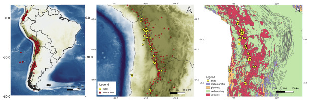 Figure 1
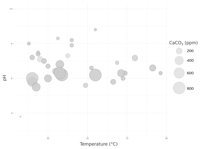 Figure 2
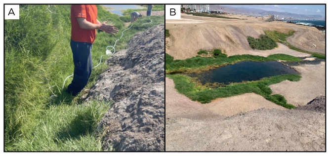 Figure 3
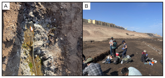 Figure 4
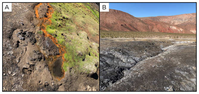 Figure 5
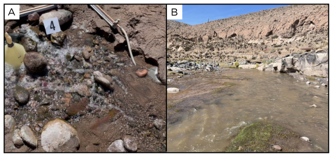 Figure 6
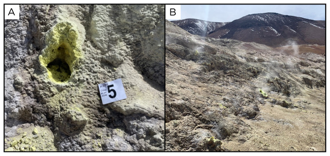 Figure 7
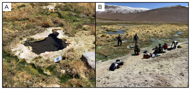 Figure 8
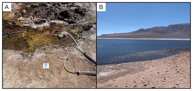 Figure 9
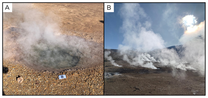 Figure 10
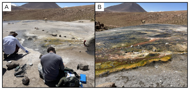 Figure 11
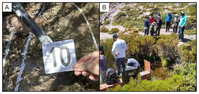 Figure 12
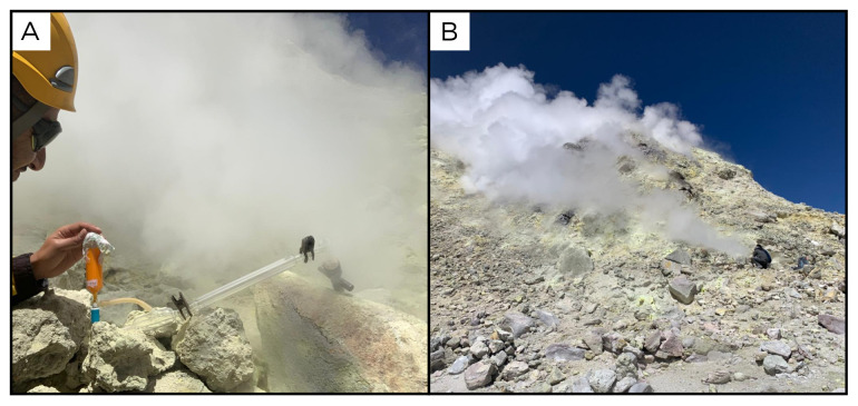 Figure 13
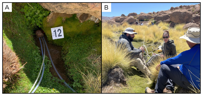 Figure 14
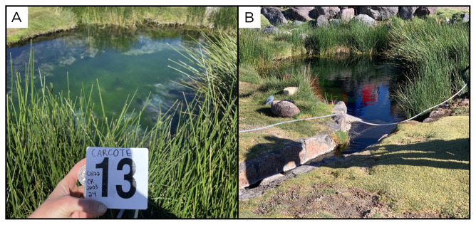 Figure 15
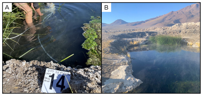 Figure 16
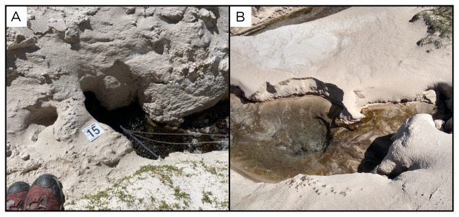 Figure 17
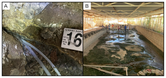 Figure 18
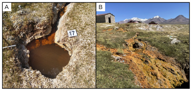 Figure 19
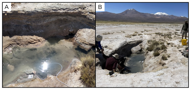 Figure 20
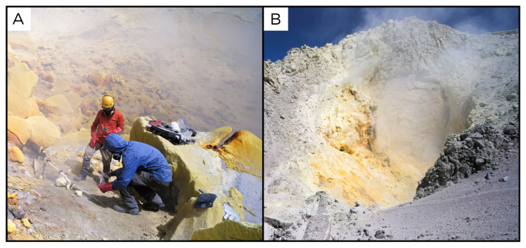 Figure 21
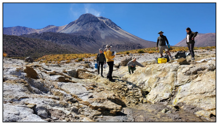 Figure 22
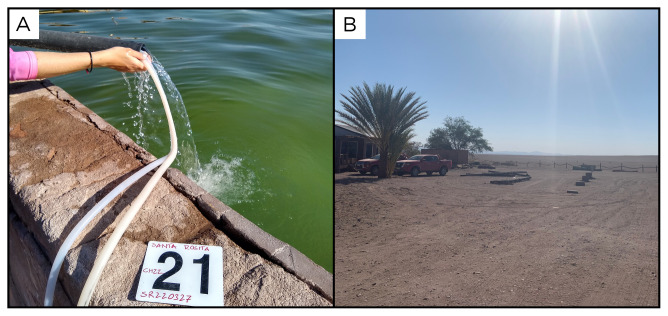 Figure 23
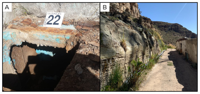 Figure 24
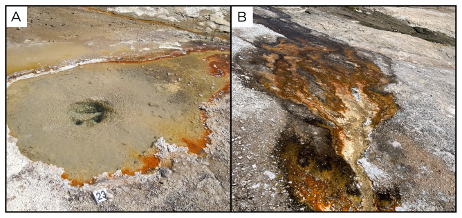 Figure 25
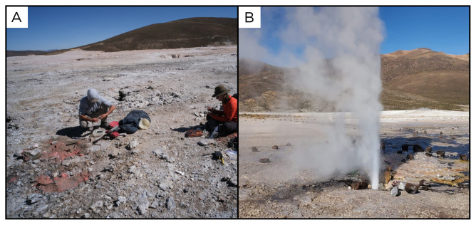 Figure 26
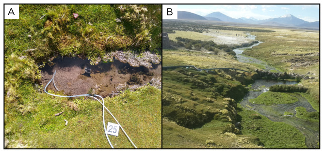 Figure 27
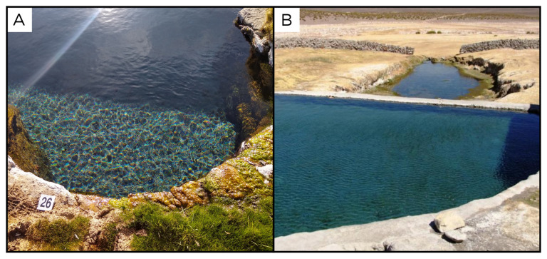 Figure 28
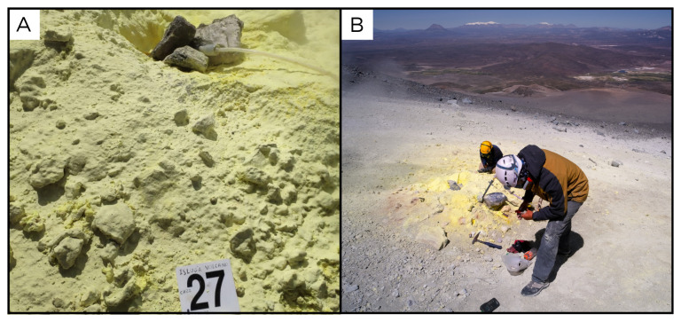 Figure 29
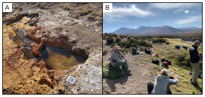 Figure 30
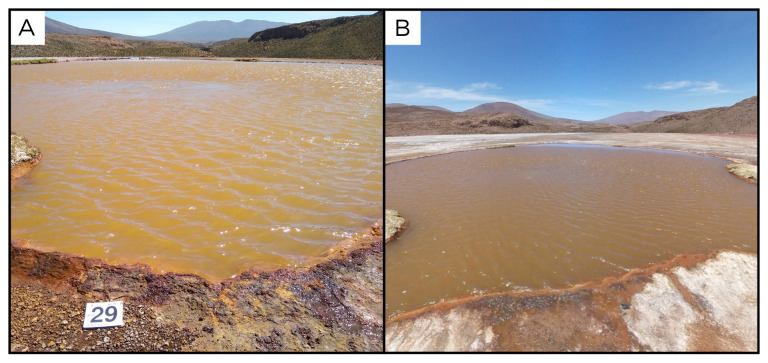 Figure 31
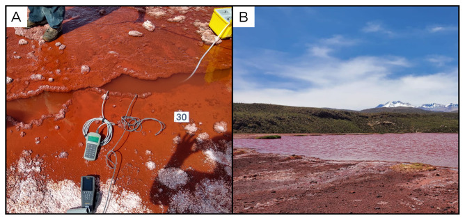 Figure 32
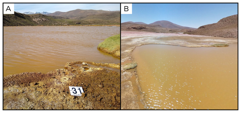 Figure 33
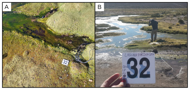 Figure 34
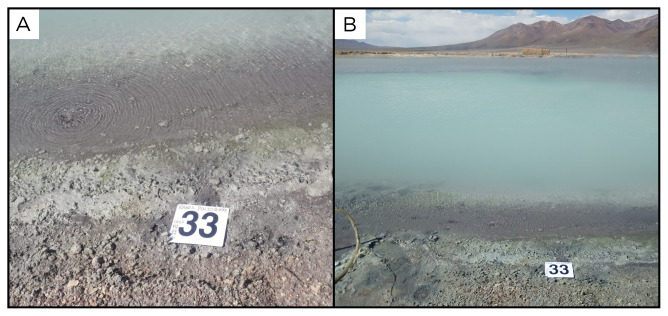 Figure 35
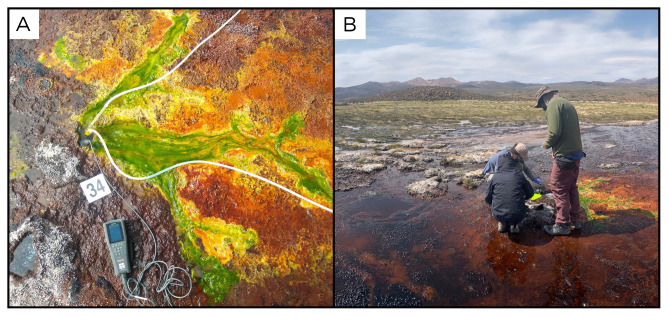 Figure 36
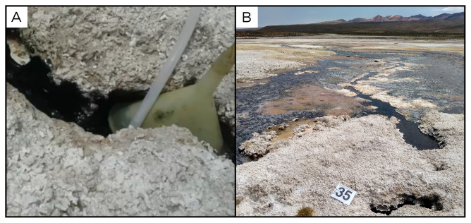 Figure 37
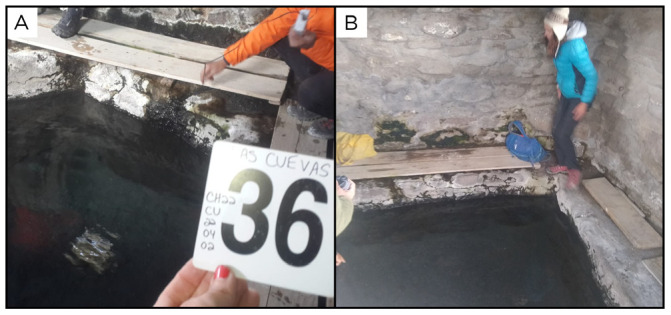 Figure 38
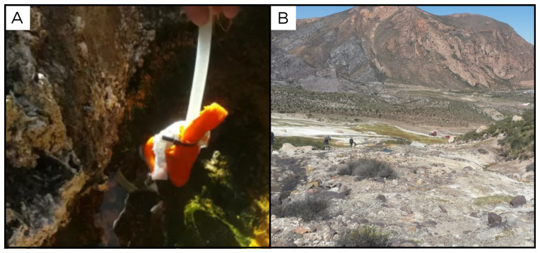 Figure 39
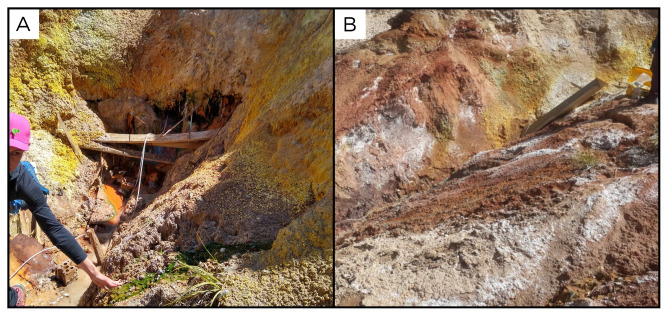 Figure 40
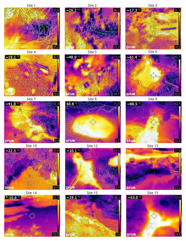 Figure 41
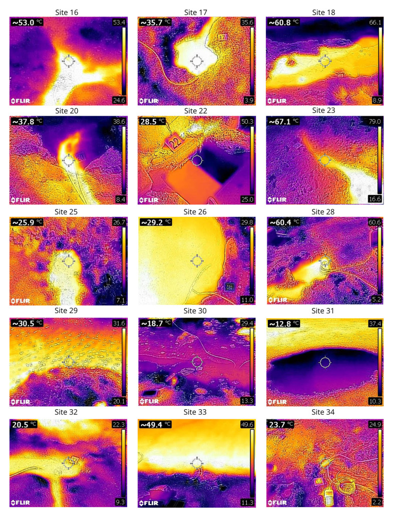 Figure 42
| SiteID | CollectionID | Temp
| pH | Latitude
| Longitude
| Altitude
| SPC
| Alkalinity
| Water
| Gas
|
|---|---|---|---|---|---|---|---|---|---|---|
| LC | 40 | 7.3 | -23.5629 | -70.4002 | 13 | 15170 | 114.1 | 9.52 | 0.000 | |
| QN220317 | QN | 26 | 7.1 | -23.6979 | -70.4064 | 94 | 39800 | 180.2 | 0.44 | 0.000 |
| CH | 22 | 5.8 | -22.4173 | -68.1726 | 3754 | 8476 | 480.4 | 0.32 | 0.103 | |
| RS220319 | RS | 22 | 6.0 | -22.2781 | -68.2277 | 3084 | 9108 | 792 | 1.89 | 2.000 |
| AL | 83 | NA | -23.1459 | -67.6553 | 4747 | NA | NA | 0.00 | NA | |
| AV | 68 | 6.0 | -23.1492 | -67.6585 | 4705 | 5332 | 99 | 1.26 | 0.246 | |
| LN | 52 | 6.6 | -23.1468 | -67.4192 | 4227 | 52600 | 87.1 | 19.28 | 0.003 | |
| ET | 87 | 6.3 | -22.3307 | -68.0118 | 4278 | 25900 | 72.1 | NA | NA | |
| GB | 83 | 6.6 | -22.3570 | -68.0226 | 4287 | 8710 | 225.2 | 5.93 | 0.802 | |
| CA | 25 | 7.4 | -22.0650 | -68.0592 | 4061 | 277 | 102.1 | 17.64 | 0.000 | |
| OL | 147 | NA | -20.9412 | -68.4833 | 5312 | NA | NA | NA | NA | |
| CC | 20.3 | 8 | -21.0251 | -68.4508 | 4266 | 91 | 60.1 | 32.50 | 0.000 | |
| CR | 42 | 7.9 | -22.0650 | -68.0593 | 4125 | 3541 | 75.1 | 10.32 | 0.000 | |
| OA220325 | OA | 28 | 7.0 | -21.6879 | -68.2149 | 3736 | 3630 | 138.1 | 9.24 | NA |
| VA220325 | VA | 22 | 7.2 | -21.6095 | -68.2501 | 3795 | 7360 | 129.1 | 2.46 | 0.000 |
| TM220326 | TM | 54 | 8.8 | -20.0704 | -69.2118 | 2804 | 1120 | 37 | 12.02 | 0.000 |
| CN | 37 | 6.2 | -19.8854 | -68.6013 | 3906 | 10120 | 819.7 | 7.56 | 0.326 | |
| TL220327 | TL | 69 | 6.3 | -19.8518 | -68.9065 | 3999 | 3000 | 117.1 | 12.53 | 0.070 |
| IR220328 | IR | 408 | NA | -20.7345 | -68.5574 | 4977 | NA | NA | NA | NA |
| IS220328 | IS | 38 | 2.4 | -20.7259 | -68.5862 | 4042 | 21120 | NA | 1.68 | 0.000 |
| SR220328 | SR | 35 | 8.3 | -20.5405 | -69.3260 | 1322 | 8089 | 54 | 0.67 | 0.000 |
| CZ | 42 | 8.2 | -19.6835 | -69.1772 | 3423 | 679 | 72.1 | 272.61 | 0.000 | |
| PZ | 74 | 7.17 | -19.4085 | -68.9585 | 4205 | 16450 | 183.2 | 2.52 | 0.004 | |
| PD | 86 | NA | -19.4128 | -68.9579 | 4222 | NA | NA | NA | NA | |
| PJ220330 | PJ | 30 | 6.7 | -19.1208 | -68.9098 | 4242 | 1769 | 111.1 | 1.86 | 0.000 |
| EQ | 30 | 6.0 | -19.2351 | -68.7920 | 3901 | 2500 | 288.3 | 136.08 | 0.000 | |
| IV220331 | IV | 97 | NA | -19.1622 | -68.8349 | 5163 | NA | NA | NA | NA |
| TT220331 | TT | 67 | 6.3 | -19.1134 | -69.1384 | 4067 | 20610 | 288.3 | 0.72 | 0.000 |
| LA | 36 | 6.8 | -19.0588 | -69.2528 | 3728 | 20880 | 360.3 | 7.12 | NA | |
| LR220331 | LR | 24 | 5.5 | -19.8518 | -68.9061 | 4079 | 29460 | 372.3 | 110.76 | 0.000 |
| LV | 49 | 5.6 | -19.0570 | -69.2534 | 3731 | 28910 | 120.1 | 10.92 | 0.000 | |
| LP | 25 | 7.5 | -19.2330 | -69.0104 | 4157 | 582 | 51 | 13.32 | NA | |
| PQ | 63 | 5.8 | -18.9132 | -68.9992 | 4283 | 12200 | 147.1 | 37.83 | NA | |
| CP220402 | CP | 16 | 3.8 | -17.9501 | -69.4362 | 4151 | 1620 | 8 | 1.33 | 0.000 |
| CE | 54 | 6.19 | -17.9555 | -69.4236 | 4141 | 34400.0 | 795.7 | 4.66 | 0.035 | |
| CU220402 | CU | 34 | 6.4 | -18.1700 | -69.4309 | 4473 | 2610 | 249.2 | 6.66 | 0.005 |
| PR220403 | PR | 36 | 6.3 | -18.1979 | -69.5385 | 3785 | 25410 | 738.6 | 0.10 | 0.008 |
| JR | 65 | 6.9 | -18.2102 | -69.5105 | 4050 | 6129 | 75.1 | 13.00 | 0.000 |
- —Horizon 2020 Framework Programme
- —FONDECYT-ANID
- —NSF FRES
- —FONDECYT
- —COPAS COASTAL ANID
Peer Reviews
No public reviews on file for this paper yet. If you reviewed it on a platform where reviews are public (OpenReview, ICLR, NeurIPS, ICML), you can paste yours below so the community can read it here.
Videos
No videos yet. Explain this paper in a talk, walkthrough, or lecture? Add one.
Taxonomy
TopicsHydrocarbon exploration and reservoir analysis · Reservoir Engineering and Simulation Methods · Hydraulic Fracturing and Reservoir Analysis
Introduction
Along convergent margins, the subduction of one plate underneath another one transports carbon and other volatiles into Earth’s deep interior and is counterbalanced by outgassing ( Kelemen & Manning, 2015) through a series of primary and secondary geothermal emissions. These manifestations release volatile species and elements that contribute to sustaining life ( Barry et al., 2019; Bekaert et al., 2021; Fullerton et al., 2021; Giovannelli et al., 2022a; Rustioni et al., 2021). Variations in subduction parameters, together with the intricate interplay between the descending slab, the overlying mantle wedge, and the overriding lithosphere, collectively exert a profound influence on the thermal and volatile fluxes produced, the nature of the underlying rock formations, and their interactions with percolating fluids, among other factors ( Eberle et al., 2002; Hu & Gurnis, 2020). Previous studies have shown that these changes can influence the subsurface microbial community diversity and its effects on the convergent margin volatile budget ( Barry et al., 2022; Basili et al., 2024; Fullerton et al., 2021; Rogers et al., 2023; Upin et al., 2023). Additionally, changes in trace elements delivered to the surface might be linked to changes in the functional diversity of the microbial community ( Giovannelli, 2023; Hay Mele et al., 2023).
The Andean Convergent Margin (ACM) represents an ocean-continent collision zone characterised by a high degree of seismic and volcanic activity, and elevated heat flow. Here, among the many volcanic manifestations, deeply sourced seeps are invaluable windows into the geological processes linked to past and present tectonic context. These seeps are the superficial manifestation of subsurface fluids, carrying with them geochemical signatures from both the mantle and the crust. While it is established that tectonic processes significantly dictate the location, temperature, and geochemical composition of geothermal fluids and related emissions, our understanding of their impact on microbial taxonomic and functional diversity remains limited. Within this framework, we sampled sediment, fluid and gas samples from 38 deeply sourced seeps and fumaroles along a ~800 km segment within the CVZ of northern Chile (17 °S and 24 °S). This project aims to understand the geochemical transformations and microbial communities in response to various subduction parameters, including crustal thickness and other factors such as carbon input from the slab, upper plate thickness, lithology, and slab dip angles, which can then be used to understand a wide range of global convergent margins. In this report, we present the field protocols alongside detailed descriptions of the sites and samples collected.
Expedition team and logistics
The expedition team was composed of 27 interdisciplinary scientists spanning the fields of microbiology, biogeochemistry, microbial ecology and gas geochemistry. The sampling was carried out along a segment of the ACM in the CVZ of northern Chile, between 17 °S and 24 °S, during the expedition CH22 conducted between March and April 2022. We collected gas, fluids and sediments from fumaroles, wells, bubbling springs and naturally flowing fluid springs, broadly defined as deeply-sourced seeps ( Giovannelli et al., 2022b), from 38 sites.
Geological and environmental settings
Situated along the Pacific's "Ring of Fire," Chile is a geologically dynamic region characterised by complex tectonic interactions. Chile stretches over 4,000 kilometres from north to south, encompassing a number of geological terrains that have been shaped through time by plate interactions between the Nazca Plate, subducting under the South American Plate at the Peru–Chile Trench, and the Antarctic Plate. The 7,000-km-long ACM serves as a paradigmatic example of a "typical" of long-lived subduction of an oceanic plate beneath a continental one ( Chen et al., 2019), and can be divided into three segments, primarily based on variations in tectonic and geological factors along its length. The northern (NVZ), central (CVZ), southern (SVZ) and Austral (AVZ) volcanic zones, divided by magmatic activity interruptions, linked to ridge and spreading plate margins subduction and changes in the angles of subduction ( Barry et al., 2022; Martinod et al., 2010; Stern, 2004).
The CVZ, located between 16 °S and 28 °S, has intense volcanic activity, and features a high concentration of stratovolcanoes ( Stern, 2004), including some of the most active ones in South America, such as Lascar, Sabancaya and Ubinas ( Aguilera et al., 2022; Stern, 2004; Stern et al., 2007). It is characterised by a unique type of subduction, where angle of subduction of the subducting plate reaches less than 30 degrees in some sections ( Bartels et al., 2022). The last Andean magmatic cycle, which is responsible for the last volcanic Arc, the current CVZ, started around 27 Ma (Late Oligocene), as a consequence of the Farallon plate break up, forming Cocos and Nazca plates. From north to south, the Andes taper from approximately 500 km across the Andean plateau to around 200 km at 35 °S, while crustal thickness decreases from over 65 km at 30 °S to less than 55 km further south ( Giambiagi et al., 2022).
Methods
Sample selection and environmental parameters
We collected gases, fluids, and sediments from fumaroles and deeply-sourced seeps ( Giovannelli et al., 2022b). In addition to including local scientists in our group and contacting national authorities to obtain permission for our work, we obtained permission from the individuals who owned the land on each site, only sampling after permission was granted. Using the sampling approach proposed by Fullerton et al. (2021), at each sampling site we identified the main water outlet by using a combination of field observation and measurements, to sample the pristine gases and fluids, minimising their interaction with the surface and the atmosphere. We also collected superficial sediment deposits that were constantly overwashed by the subsurface fluids, as well as background soil samples from the nearby area that did not show geothermal alterations. The rationale behind this type of sampling approach was to maximise the subsurface information that can be extrapolated from the data, knowing which communities are found exclusively in the seep and those shared with the surrounding areas ( Giovannelli et al., 2022b). Each sampling location was photographed using a FLIR C2 thermal camera and a digital camera ( Figure 1). Total alkalinity (expressed as mg/L CaCO 3), and silica were analysed in situ by (i) acidimetric titration using HCl 0.03 N, phenolphthalein and bromophenol blue as indicators, and (ii) molecular spectrophotometry (Hanna HI 96770C; accuracy: ±1 mg/L). Temperature, conductivity, pH, redox potential, total suspended solids and dissolved oxygen were measured in the field using a thermocouple and a multiparametric probe (HANNA, HI98196, accuracy: ±0.15 °C, ±0.02 pH) ( Figure 2). Water emission rates were estimated by measuring the spring outlet dimensions and the water flow velocity using a FL-K1 stream flow metre, handheld rod with impeller and LCD readout (JDC Instruments Electronics Flowatch Flowmeter). Gas fluxes were estimated by placing a volume-calibrated inverted funnel full of water over the bubbling source and measuring the time taken to displace a known volume of water.
Map showing the location of the sampling sites and their geological context. A) General overview of the Andean Volcanic Zones. The sampled area presented in ( B) and ( C) is marked with a red rectangle; B) Topographic map showing the location of the sampled seeps; and C) geological maps of the sampled area showing the main geological units ( “Geological Map Of South America At a Scale of 1:5,000,000”, 2019), https://doi.org/10.32685/10.143.2019.929) (geological basemap from Gómez et al., 2019).
Graph showing the temperature, pH, and total alkalinity of the sampled locations.Temperature in °C and total alkalinity in ppm of CaCO 3 (concentrations are proportional to the size of the circles).
Geochemistry samples acquisition
** Dissolved gas geochemistry. ** Gas phase samples and water samples for dissolved gases were collected in pre-evacuated 250 ml Giggenbach bottles containing 50 ml of 4 N NaOH minimising atmospheric contamination ( Barry et al., 2019). Copper tubes for the determination of the noble gas composition were collected at each site. Gases and fluids were first flushed into silicone tubes and through 3/8-inch copper tubes, that were then closed with stainless steel clamps after extensive flushing, trapping the sample inside the copper tubing ( Barry et al., 2022). The tubing used for Cu-tubes was also used to collect gas samples using Giggenbach bottles.
** Aqueous and sediment geochemistry. ** At each site, we took sediment samples as close as possible to the water outlet point, and collected them into 50 ml conical tubes, prewashed in soap and water and then in acid, to avoid any possible metal contamination. We collected two 50 ml conical tubes of 0.22 µm filtered fluids for ion chromatography (IC) and ion coupled plasma mass spectrometer (ICP-MS) analysis ( Correggia et al., 2023; Correggia et al., 2024). Samples for ICP-MS analysis were acidified with nitric acid to estimate acid-soluble metals. We also collected a 10 ml anoxic vial for dissolved inorganic carbon. All the equipment was acid washed to avoid metal contamination.
Biological samples acquisition
We sampled sediments and fluids for molecular analysis, with the sampling approach proposed by Fullerton et al., 2021. For each site, we filtered between 2 to 4 litres of hydrothermal fluids through a Sterivex 0.22 µm filter (Millipore Sigma) using a portable 3D printed peristaltic pump powered through an battery portable drill. The plans to print and reproduce the peristaltic pump are available at DOI: http://dx.doi.org/10.5281/zenodo.12742933. The fluids were collected as close as possible to the venting outlet to prevent mixing with the surface as described previously ( Giovannelli et al., 2022b). Using 50 ml falcon tubes, we collected sediments as close as possible to the water outlet, and background soils choosing the closest point to the seep which showed no signs of influence from the hydrothermal activity. Filters and sediments were immediately frozen onsite at liquid nitrogen temperature in a cryogenic dry shipper (ThermoFisher Scientific, Arctic Express 20). To identify and count cells using flow cytometry, we sampled a 2 ml cryovial of fluid and a 2 ml cryovial of sediment, both of which were preserved in 3 % paraformaldehyde. Finally, we filled 100 ml vials with biofilms of various colours, microbial mats, fluids, and sediments, for culturing and isolation purposes.
Sites and samples log
We named each site using the following convention:
- The ISO Alpha-3 country code or a two-letter project specific code is used to assign the name to the expedition followed by a two numeric digit indicating the year called ExpID (e.g., MNG23);- Each sampling site is identified using a two-letter code selected from the name of the location, called SiteID (e.g., NR for …);- Each sampling effort is identified by the SiteID followed by the sampling date in the YYMMDD format, called a CollectionID (e.g., NR230731). This gives a unique identifier of the sample based on the location and the date;- The different samples collected during each collection are identified by each participating group using tags specific for the type of analysis carried out.
Physicochemical characteristics of each site and the measured parameters in the field are reported in Table 1. The description of each sampled location follows together with pictures useful for future identification of the site. A .kmz file containing the exact location of the sampled sites is available on the online GitHub repository associated with this report ( https://github.com/giovannellilab/Chile_2022_expedition.git).
Site 1 - La Chimba, LC220316 (-23.5629 °N, -70.4002 °E)
The LC220316 ( Figure 3) spring was the first site sampled during this expedition. It is situated approximately 30 metres from the seashore, near the city of Antofagasta, at an elevation of 13 metres above sea level. The site features a water outlet hidden within the grass ( Figure 3), which feeds a small pool at its base. No gas bubbles are present. The spring and its associated pool are encompassed by various forms of vegetation. The site is surrounded by evidence of animal activity and traces, and human-generated litter.
La Chimba, LC220316.Fluids were sampled from a small water outlet point between the grass. A. Detail of the sampling location where the fluids were collected. B. Large view of the sampling site. Photograph taken by author DB for this publication.
Site 2 - Quebrada Negra, QN220317 (-23.6979 °N, -70.4064 °E)
Site QN220317 lies on the edge of the city of Antofagasta, within the dry bed of an arheic basin, at an altitude of 93 metres above sea level ( Figure 4). The water outlet was identified inside a channel into the ground. The site is located about 500 metres from the road, so it is easily accessible by car. The site harbours indications of human impact, as remnants of discarded trash are found within it, alongside signs of animal presence such as tracks and traces.
Quebrada Negra, QN220317. A. Detail of the sampling location where the fluids were collected. B. Large view of the sampling site. Photograph taken by author DB for this publication.
Site 3 - Chitor, CH220319 (-22.4173 °N, -68.1726 °E)
Site CH220319 is nestled in the heart of the Atacama Desert, approximately 90 kilometres from the city of Calama ( Figure 5). This remote location is at an elevation of 3754 metres above sea level. Chitor is about 150 metres away from the main road, and accessible by car. The site is located in a flat basin surrounded by mountains and hills, suggesting that rainwater likely funnels into this basin. The water leak point emerges in an area surrounded by sparse vegetation, with the presence of animal tracks. Around the water outlet there is evidence of iron precipitation, and the mound has some carbonate deposition. The water flow is low and CO 2-rich.
Chitor, CH220319. A. Detail of the sampling location where the fluids were collected. B. Large view of the sampling site. Photograph taken by author DB for this publication.
Site 4 - Rio Salado, RS220319 (-22.2781 °N, -68.2277 °E)
Site RS220319 was sampled on the bank of the Rio Salado river, that flows near the city of Calama, at an altitude of 3084 metres above sea level ( Figure 6). The site is close to a road, and we crossed the river on foot to reach the site we selected for sampling. On the river bank there are three water outlet points, all close to each other and each with high flux of gas bubbles.
Rio Salado, RS220319.Fluids were sampled from a bubbling water outlet point next to the river. A. Detail of the sampling location where the fluids were collected. B. Large view of the sampling site. Photograph taken by author DB for this publication.
Site 5 - Alitar fumaroles, AL220320 (-23.1459 °N, -67.6553 °E)
Site AL220320 is located within the fumarole of the Alitar volcano, at an altitude of 4747 metres above sea level ( Figure 7). The site is located inside the volcano's crater, with diffuse degassing of H _2_S. Given the high temperature of the fumarole, we only collected sediments and gas samples at this site, and targeted an area with relatively lower temperature, 83°C for microbiological sampling.
Alitar fumaroles, AL220320. A. Detail of the sampling location where the samples were collected. B. Large view of the sampling site. Photograph taken by author DG for this publication.
Site 6 - Alitar verde, AV220320 (-23.1492 °N, -67.6585 °E)
Site AV220320 is located near the Alitar fumaroles site, at an altitude of 4705 metres above sea level ( Figure 8). It is a marshy area fed by emissions of hot underground water, at around 68 ° C, with moderate bubbling. The pool is surrounded by limestone encrustations, and while the inside of the sampled pool is clear and free from vegetation and algae, all around there is vegetation, animal tracks and green and white biofilm.
Alitar verde, AV220320. A. Detail of the sampling location where the fluids were collected. B. Large view of the sampling site. Photograph taken by author JP for this publication.
Site 7 - Laguna Negra, LN220321 (-23.1468 °N, -67.4192 °E)
Site LN220321 is near the shore of a system of three salares and lagoons, alternating between periods of desiccation and replenishment by rainwater cascading from the surrounding hills ( Figure 9). This site is easily accessible by car, and the water outlet point selected for the sampling is a 52°C water release along the shoreline of the Laguna Negra lagoon. The site has small, intermittent gas emissions, and inside the pool there are green and brown biofilms, surrounded by whitish carbonate concretions.
Laguna Negra, LN220321.Fluids were sampled from a water outlet point near the lake. A. Detail of the sampling location where the fluids were collected. B. Large view of the sampling site. Photograph taken by author DG for this publication.
Site 8 - El Tatio, ET220322 (-22.3307 °N, -68.0118 °E)
Site ET220322 is located within the El Tatio geothermal field, near San Pedro de Atacama ( Figure 10). With an altitude of 4278 metres above sea level, El Tatio is one of the highest-altitude geothermal fields in the world, known for its numerous geysers, hot springs, and fumaroles. Among the many pools, we chose to sample one with a temperature of 87°C, which was slightly lower than other pools. The sampled pool was surrounded by sandy and gravelly sediment, while inside the pool there was very little fine sediment, and mostly pieces of sinter encrustations that had fallen from the sides.
El Tatio, ET220322.Fluids were sampled from the pool, as close as possible to the water outlet. A. Detail of the sampling location where the fluids were collected. B. Large view of the sampling site. Photograph taken by author DG for this publication.
Site 9 - Geyser Blanco, GB220322 (-22.3570 °N, -68.0226 °E)
Site GB220322 is approximately 3 km from the El Tatio geothermal field, with an altitude of 4287 metres above sea level ( Figure 11). It is a water emission site at 83°C, where water flows along a hill producing a small stream with limestone deposits as well as biofilms of various colours, including green, white and orange. The site lacked vegetation, but showed animal traces.
Geyser Blanco, GB220322. A. Detail of the sampling location where the fluids were collected. B. Large view of the sampling site. Photograph taken by author DB for this publication.
Site 10 - Cabana, CA220323 (-22.0650 °N, -68.0592 °E)
Site CA220323 is located at about 5 km from Cabana at an altitude of 4061 metres above sea level ( Figure 12). It is a hot spring surrounded by vegetation, located in a valley surrounded by hills and mountains. In the pool, the high water flow is artificially channelled through a series of pipes. The water flows out at a temperature of 25°C. There were fish inside the pool. The site is close to old sulphur mine tailings and buildings distributed in the area.
Cabana, CA220323.Fluids were sampled from the water outlet point, at the bottom of the pool. A. Detail of the sampling location where the fluids were collected. B. Large view of the sampling site. Photograph taken by author DG for this publication.
Site 11 - Olca Volcano, OL220324 (-20.9412 °N, -68.4833 °E)
Site OL220324 is a fumarole field on the Olca volcano, at 5312 metres above sea level ( Figure 13). Olca is a stratovolcano located on the border with Bolivia, and its gases emissions come from a fumarole field over the crater's dome. The temperature recorded at the sampling point is 147°C, and no fluids for biological analysis were sampled.
Olca Volcano, OL220324.No fluids were sampled at this site. A. Detail of the sampling location. B. Large view of the sampling site. Photograph taken by author JP for this publication.
Site 12 - Vega Churchilla, CC220324 (-21.0251 °N, -68.4508 °E)
Site CC220324 is located in the municipality of Ollagüe, a small city at the base of the andesitic Ollagüe stratovolcano ( Figure 14). The point of emission of the water, which comes out at a temperature of 20.3 °C, is located within a relatively flat area, surrounded by hills and mountains. The entire area is covered by low vegetation and ignimbrites outcrops. The site is at an altitude of 4266 metres above sea level, and has no gas phase.
Vega Churchilla, CC220324.Fluids were sampled from the water outlet point. A. Detail of the sampling location where the fluids were collected. B. Large view of the sampling site. Photograph taken by author DB for this publication.
Site 13 - Carcote, CR220324 (-22.0650 °N, -68.0593 °E)
Site CR220324 is located 4125 metres above sea level, near the Salar de Carcote ( Figure 15). The site consists of a water outlet at 42°C, with no gas, feeding a pool used by tourists.
Carcote, CR220324. Fluids were sampled from the water outlet point, before reaching the pool. A. Detail of the pool. B. Large view of the sampling site. Photograph taken by author KGL for this publication.
Site 14 - Ojo de Ascotán vertiente, OA220325 (-21.6879 °N, -68.2149 °E)
Site OA220325 has an altitude of 3736 metres above sea level, and is one of a series of pools in the middle of a salar ( Figure 16). Fluids and bubbles come out of a horizontal pipe inside the pool sampled. The source of the water, which we measured at 28 ° C, is apparently a 200 m deep well in the Salar de Ascotán, as told to us by the caretakers of the site.
Ojo de Ascotán vertiente, OA220325.Fluids were sampled from the water outlet point, at the bottom of the pool. A. Detail of the sampling location where the fluids were collected. B. Large view of the sampling site. Photograph taken by author DB for this publication.
Site 15 - Vertiente 10 Ascotán, VA220325 (-21.6879 °N, -68.2149 °E)
Site VA220325 is a salty spring on the edge of the Salar de Ascotán, 3795 metres above sea level and water is 22 ° C ( Figure 17). The water flows out of sandy sediment and feeds a small pool with algae, aquatic vegetation, and animals.
Vertiente 10 Ascotán, VA220325.Fluids were sampled from the water outlet point, at the bottom of the pool. A. Detail of the sampling location where the fluids were collected. B. Large view of the sampling site. Photograph taken by author KGL for this publication.
Site 16 - Termas de Mamiña, TM220326 (-20.0704 °N, -69.2118 °E)
Site TM220326 is a spring in Mamiña, a small village 130 kilometres east of Iquique, 2804 metres above sea level ( Figure 18). Fluids were 54 ° C, and with a pH of 8.8, making this the most alkaline spring sampled. The water flows into an artificial structure, with extensive mats and biofilms of different colours, and eventually is used by the inhabitants of the nearby town.
Termas de Mamiña, TM220326.Fluids were sampled from the water outlet point. A. Detail of the sampling location where the fluids were collected. B. Large view of the sampling site. Photograph taken by author KGL for this publication.
Site 17 - Termas de Cancosa, CN220327 (-19.8854 °N, -68.6013 °E)
Site CN220327 is 3906 metres above sea level and 37 ° C, with strong bubbling, iron precipitation and travertine deposition all around it ( Figure 19). At approximately 50 metres from the spring there is a small stone hut with a pool inside, showing strong bubbling.
Termas de Cancosa, CN220327.Fluids were sampled from the water outlet point, at the bottom of the pool. A. Detail of the sampling location where the fluids were collected. B. Large view of the sampling site. Photograph taken by author DB for this publication.
Site 18 - Termas de Lirima, TL220327 (-19.8518 °N, -68.9065 °E)
Site TL220327 is on a large sinter dome, with bluish coloured pools, all characterised by strong and intermittent bubbling ( Figure 20). The site is located at an altitude of 3999 metres above sea level, and the fluids are 69 ° C. The pools are all surrounded by sinter concretions, inside them there is very fine and dark sediment, and around them are animal carcasses.
Termas de Lirima, TL220327.Fluids were sampled from the water outlet point, at the bottom of the pool. A. Detail of the sampling location where the fluids were collected. B. Large view of the sampling site. Photograph taken by author DB for this publication.
Site 19 - Irruputuncu fumaroles, IR220328 (-20.7345 °N, -68.5574 °E)
Site IR220328 is a fumarole in the southernmost crater of the Irruputuncu volcano, at 4977 metres above sea level. At 408 ° C, this was the highest temperature site sampled in the expedition. All around the site there is strong degassing, with native sulphur deposits and high temperature acid gases ( Figure 21). Near the site there is an old sulphur mining infrastructure. No aqueous phase samples were available for collection at this specific site.
Irruputuncu fumaroles, IR220328.No fluids were available to be sampled at this location. A. Detail of the sampling location. B. Large view of the sampling site. Photograph taken by author JP for this publication.
Site 20 - Irruputuncu acid spring, IS220328 (-20.7259 °N, -68.5862 °E)
Site IS220328 is an acidic spring located near the base of the Irruputuncu volcano, at 4042 metres above sea level, and with a fluid temperature of 38 ° C ( Figure 22). With a pH of 2.4, it is the most acidic spring sampled during this expedition. There are two main water emissions at the sampling location, both with very very limited water flow. Only one of the two had sufficient flow to sample. Near the water outlet, the sediment is sparse and coarse.
Irruputuncu acid spring, IS220328. Fluids were sampled from the water outlet point, near the pool. A. Detail of the sampling location where the fluids were collected. B. Large view of the sampling site. Photograph taken by author JP for this publication.
Site 21 - Santa Rosita, SR220328 (-20.5405 °N, -69.3260 °E)
Site SR220328 is near the city of Pica, 1322 metres above sea level ( Figure 23). Here the fluids flow from a pipe, supplying a private swimming pool, at 35 ° C. As suggested by the owner of the property, the water is sourced from a nearby natural well. At this site, there is no gas phase, and we did not collect any sediment samples.
Santa Rosita, SR220328.Fluids were sampled from the water outlet point, near the pool. A. Detail of the sampling location where the fluids were collected. B. Large view of the sampling site. Photograph taken by author DG for this publication.
Site 22 - Termas de Chusmiza, CZ220329 (-19.6835 °N, -69.1772 °E)
Site CZ220329 has an altitude of 3423 metres above sea level ( Figure 24). This location has pools with therapeutic thermal water, which serve as an attraction for both residents and tourists. The sampled site is located along a road accessible by car. Fluids were sampled from a concrete tank inside a rock wall, where fluids are 42 ° C. Surrounding the site, thermal water emerges directly from the rock wall.
Termas de Chusmiza, CZ220329.Fluids were sampled from the water outlet point. A. Detail of the sampling location where the fluids were collected. B. Large view of the sampling site. Photograph taken by author DB for this publication.
Site 23 - Puchuldiza outflow, PZ220330 (-19.4085 °N, -68.9585 °E)
Site PZ220330 site, 4205 metres above sea level, is approximately 200 metres from the Puchuldiza geothermal field, in the Tarapacá Region ( Figure 25). The spring is located on a dome, at the outer edge of the fumarole/geyser field. Here, fluids have moderate bubbling and a temperature of 74 ° C, flowing downhill in a small stream, with abundant biofilms ranging between green, orange and white, releasing hot fluids into the Puchuldiza River.
Puchuldiza outflow, PZ220330.Fluids were sampled from the water outlet point. A. Detail of the sampling location where the fluids were collected. B. Large view of the sampling site. Photograph taken by author DG for this publication.
Site 24 - Puchuldiza fumarole, PD220330 (-19.4128 °N, -68.9579 °E)
Site PD220330 is in the Puchuldiza geothermal field, in the Tarapacá Region, at an altitude of 4222 metres above sea level ( Figure 26). This area lies within a tectonic graben, and features over a hundred separate geothermal manifestations, such as geysers, fumaroles, and boiling pools. At this site, we measured the temperature at 86 ° C, and we collected condensate samples.
Puchuldiza fumarole, PD220330. A. Detail of the sampling location where the gases were collected. B. View of a geyser close to the sampling site. Photograph taken by author JP for this publication.
Site 25 - Parajaya, PJ220330 (-19.1208 °N, -68.9098 °E)
Site PJ220330 is close to Río Todos Santos, a river that flows across the Tarapacá Region ( Figure 27). This spring is located in a valley with low vegetation, at an altitude of 4242 metres above sea level, with high water outflow, vegetation, and a temperature of 30 ° C.
Parajaya, PJ220330. Fluids were sampled from the water outlet point. A. Detail of the sampling location where the fluids were collected. B. Large view of the sampling site. Photograph taken by author DB for this publication.
Site 26 - Termas de Enquelga, EQ220330 (-19.2351 °N, -68.7920 °E)
Site EQ220330 is near the small city of Enquelga, at 3901 metres above sea level ( Figure 28). Here, the fluid outlet point is in the wall of a large swimming pool, with high outflow at a temperature of 30 ° C and no gas phase. The pool is frequently used by tourists and locals. After the first swimming pool, the water flows into a second, natural pool.
Termas de Enquelga, EQ220330.Fluids were sampled from the water outlet point. A. Detail of the sampling location where the fluids were collected. B. Large view of the sampling site. Photograph taken by author DB for this publication.
Site 27 - Isluga volcano, IV220331 (-19.1622 °N, -68.8349 °E)
Site IV220331 is a high flux fumarole on the upper flanks of the Isluga stratovolcano, in Colchane, 7 km from the Chilean-Bolivian border, at 5163 metres above sea level ( Figure 29). No fluids were available to be sampled at this site, but we collected condensate samples. The registered temperature at the site where sediments were collected was 97 ° C.
Isluga volcano, IV220331 Fluids were sampled from the water outlet point. A. Detail of the sampling location where the fluids were collected. B. Large view of the sampling site. Photograph taken by author JP for this publication.
Site 28 - Terma Tana, TT220331 (-19.1134 °N, -69.1384 °E)
Site TT220331 is a hot spring with no gas phase, at 4067 metres above sea level, and a temperature of 67 ° C ( Figure 30). The spring is located on the slope of a small hill, with low vegetation, and is surrounded by carbonate and iron deposits.
Termal Tana, TT220331.Fluids were sampled from the water outlet point. A. Detail of the sampling location where the fluids were collected. B. Large view of the sampling site. Photograph taken by author DG for this publication.
Site 29 - Laguna Amarilla, LA220331 (-19.0588 °N, -69.2528 °E)
Site LA220331 is at the bottom of a 24 m wide lagoon, called Laguna Amarilla, which, together with the Lagura Roja and Laguna Verde, constitute the Lagunas the Amuyo ( Figure 31). These lagunas are located within the Arica y Parinacota Region, and feed the Caritaya river, which flows north, at the base of the dome on which the three lagoons are located. This laguna has an altitude of 3728 metres above sea level, with fluids at 36 ° C. Gas emanates from the centre of the deep pool.
Laguna Amarilla, LA220331.Fluids were sampled from the water outlet point. A. Detail of the sampling location where the fluids were collected. B. Large view of the sampling site. Photograph taken by author DB for this publication.
Site 30 - Laguna Roja, LR220331 (-19.8518 °N, -68.9061 °E)
Site LR220331 is on the shores of the Laguna Roja, the second of the three Lagunas the Amuyo, at an altitude of 4079 metres above sea level ( Figure 32). This location stands approximately at the centre of the dome where the three lagunas are located, halfway between the other two. This laguna is a red iron-rich pool with encrustations around edges, with a number of small emissions all around the edges of the pool. We chose one with relatively high water flux, and with a temperature of 24 ° C.
Laguna Roja, LR220331 Fluids were sampled from the water outlet point. A. Detail of the sampling location where the fluids were collected. B. Large view of the sampling site. Photograph taken by author DG for this publication.
Site 31 - Laguna Verde, LV220331 (-19.0570 °N, -69.2534 °E)
Site LV220331 is on the shore of Laguna Verde, the farthest south of the three Lagunas de Amuyo, at an altitude of 3731 metres above sea level ( Figure 33). The pool is surrounded by encrustations and its outflow ends up in the Caritaya river. Among the three lagunas, this is the warmest, with a temperature of 49 ° C.
Laguna Verde, LV220331.Fluids were sampled from the water outlet point. A. Detail of the sampling location where the fluids were collected. B. Large view of the sampling site. Photograph taken by author DG for this publication.
Site 32 - Laguna Parinacota, LP220401 (-19.2330 °N, -69.0104 °E)
Site LP220401, at an altitude of 4157 metres above sea level, is one of two high outflow springs feeding the Laguna Parinacota ( Figure 34). This lagoon is close to the Colchane village and seasonally alternates between dry and flood periods. The site is northwest of the lagoon, on a hillside, with 25 ° C fluids flowing into the lagoon, creating small streams with biofilm and algae.
Laguna Parinacota, LP220401.Fluids were sampled from the water outlet point. A. Detail of the sampling location where the fluids were collected. B. Large view of the sampling site. Photograph taken by author DB for this publication.
Site 33 - Baños Polloquere, PQ220401 (-18.9132 °N, -68.9992 °E)
Site PQ220401 is located on the shore of a large steaming salt lake, on the southern edge of Salar de Surire, in the Arica y Parinacota Region ( Figure 35). This site has an altitude of 4283 metres above sea level, and is located on one side of the lake, shows strong consistent bubbling and a fluid temperature of 63 ° C.
Baño Polloquere, PQ22040.1 Fluids were sampled from the water outlet point. A. Detail of the sampling location where the fluids were collected. B. Large view of the sampling site. Photograph taken by author DB for this publication.
Site 34 - Colpitas, CP220402 (-17.9501 °N, -69.4362 °E)
Site CP220402, at an altitude of 4151 metres above sea level in the Arica y Parinacota Region, is located at the edge of an old inactive geothermal area, with multiple fluid sources, small water streams, and small pools ( Figure 36). With a temperature of 16 °C, this is the spring with the lowest temperature sampled on this expedition and shows very low and intermittent gas bubbles. Fluids flow out of the spring, leaving all around the seep thick microbial mats of different colours, ranging from yellow, orange, brown, and green.
Colpitas, CP220402.Fluids were sampled from the water outlet point. A. Detail of the sampling location where the fluids were collected. B. Large view of the sampling site. Photograph taken by author JP for this publication.
Site 35 - Colpitas Este, CE220402 (-17.9555 °N, -69.4236 °E)
Site CE220402 is a warm bubbling spring on the edge of an old inactive geothermal area/salar, located at an altitude of 4141 metres above sea level, in the Arica y Parinacota Region, with 54 °C fluids ( Figure 37). Around the chosen site there are other seeps, which flow into small streams of water across the salar.
Colpita Este, CE220402. Fluids were sampled from the water outlet point. A. Detail of the sampling location where the fluids were collected. B. Large view of the sampling site. Photograph taken by author DB for this publication.
Site 36 - Las Cuevas, CU220402 (-18.1700 °N, -69.4309 °E)
Site CU220402, also known as Termas de Las Cuevas, is near the location of Las Cuevas, at an altitude of 4473 metres above sea level, with 34 ° C fluids ( Figure 38). The outflow feeds an artificial pool with weak intermittent bubbling within a hut. The water from the spring flows outside the hut, creating a wet area with small streams and abundant biofilms and mats of different colours.
Las Cuevas, CU220402.Fluids were sampled from the water outlet point. A. Detail of the sampling location where the fluids were collected. B. Large view of the sampling site. Photograph taken by author KGL for this publication.
Site 37 - Putre, PR220403 (-18.1979 °N, -69.5385 °E)
Site PR220403 is a small moderately bubbling spring located on the highest point of a large travertine mound, next to the main road ( Figure 39). It has an altitude of 3785 metres above sea level, and fluids flow along the slope of the mound forming a network of small streams at a temperature of 36 ° C. This site was reported by Inostroza et al., 2020 as a Na-Cl type water site.
Putre, PR220403.Fluids were sampled from the water outlet point. A. Detail of the sampling location where the fluids were collected. B. Large view of the sampling site. Photograph taken by author DB for this publication.
Site 38 - Termas de Jurasi, JR220403 (-18.2102 °N, -69.5105 °E)
JR220403 was the last site sampled in our expedition. This site, at an altitude of 4050 metres above sea level, is a high outflow hot spring located within a private hot springs complex with baths used by tourists and locals ( Figure 40). Here, multiple water sources feed into the pools. Our spring, with a temperature of 65 ° C, doesn’t feed any pool, and flows out from an extremely hydrothermally-altered wall, a few metres above the pools.
Termas de Jurasi, JR220403. Fluids were sampled from the water outlet point. A. Detail of the sampling location where the fluids were collected. B. Large view of the sampling site. Photograph taken by author DG for this publication.
Thermal images of the sampled seeps
Themal images of the sampled seeps have been collected at each location to assist in sampling site selection and inform on the structure of the seep ( Figure 41 and Figure 42).
Thermal photos of the sampling sites 1 to 15 taken with a FLIR C2 thermal camera.Photograph taken by author CJR for this publication.
Thermal photos of the sampling sites 16 to 34 taken with a FLIR C2 thermal camera.Photograph taken by author CJR for this publication.
Summary
The expedition successfully sampled 38 sites, including deeply sourced springs and fumaroles. The data obtained will be made public according to the FAIR Principles for scientific data management.
Ethical approval and consent
Ethical approval and consent were not required.
The reference list from the paper itself. Each links out to its DOI / PubMed record.
- 1Aguilera F Apaza F Del Carpio J : Advances in scientific understanding of the central volcanic zone of the andes: a review of contributing factors. Bull Volcanol. 2022;84(3): 22. 10.1007/s 00445-022-01526-y · doi ↗
- 2Barry PH De Moor JM Chiodi A : The helium and carbon isotope characteristics of the andean convergent margin. Front Earth Sci. 2022;10. 10.3389/feart.2022.897267 · doi ↗
- 3Barry PH Nakagawa M Giovannelli D : Helium, inorganic and organic carbon isotopes of fluids and gases across the costa rica convergent margin. Sci Data. 2019;6(1): 284. 10.1038/s 41597-019-0302-4 31767867 PMC 6961234 · doi ↗ · pubmed ↗
- 4Bartels C Curtice J de Moor MJ : The influence of magma bodies on CO 2 degassing throughout the central volcanic zone of the andean convergent margin.2022; DI 25D-0044. Reference Source
- 5Basili M Rogers TJ Nakagawa M : Subsurface microbial community structure shifts along the geological features of the central american volcanic arc.2024. 10.31223/x 5hm 55 PMC 1156001939536057 · doi ↗ · pubmed ↗
- 6Bekaert DV Turner SJ Broadley MW : Subduction-Driven volatile recycling: a global mass balance. Annu Rev Earth Planet Sci. 2021;49(1):37–70. 10.1146/annurev-earth-071620-055024 · doi ↗
- 7Chen YW Wu J Suppe J : Southward propagation of nazca subduction along the andes. Nature. 2019;565(7740):441–447. 10.1038/s 41586-018-0860-1 30675041 · doi ↗ · pubmed ↗
- 8Correggia M di Iorio L Bastianoni AB : Standard operating procedure for the analysis of major ions in hydrothermal fluids by ion chromatography. Open Res Eur. 2024;3:94. 10.12688/openreseurope.15605.2 39263358 PMC 11387938 · doi ↗ · pubmed ↗