Mapping Vulnerability to Potential Crisis Events in Surabaya City: A GIS-Based Approach
Ali E. M. Jarghon, Nyoman Anita Damayanti, Inge Dhamanti, Hari Basuki Notobroto, Atik Choirul Hidajah, Anas M. M. Awad, Subham Roy, Ali Jarghon, Peiman Ghasemi, Ali Jarghon

TL;DR
This study creates a vulnerability map for Surabaya using GIS to assess how susceptible the city is to crises like the COVID-19 pandemic.
Contribution
The paper introduces a GIS-based Multi-Criteria Decision Analysis approach tailored for Surabaya's vulnerability assessment.
Findings
Six key factors were identified and weighted to determine vulnerability levels.
Surabaya's vulnerability was classified into five distinct levels using GIS.
The map supports targeted resource allocation and response strategies for vulnerable areas.
Abstract
This study aims to develop a vulnerability map for Surabaya using GIS-based Multi-Criteria Decision Analysis (MCDA) to assess the city’s vulnerability to COVID-19. Six key factors influencing vulnerability were identified and their relative importance determined through the Analytic Hierarchy Process (AHP) pairwise comparison matrix. GIS was utilized to classify Surabaya’s vulnerability into five levels: very low, low, medium, high, and very high. The resulting vulnerability map provides essential insights for decision-makers, healthcare professionals, and disaster management teams. It enables strategic resource allocation, targeted interventions, and formulation of comprehensive response strategies tailored to specific needs of vulnerable districts. Through these measures, Surabaya can enhance its resilience and preparedness, ensuring the well-being of its residents in the face of…
Genes, proteins, chemicals, diseases, species, mutations and cell lines named across the full text — each resolved to its canonical identifier and authoritative record.
Click any figure to enlarge with its caption.
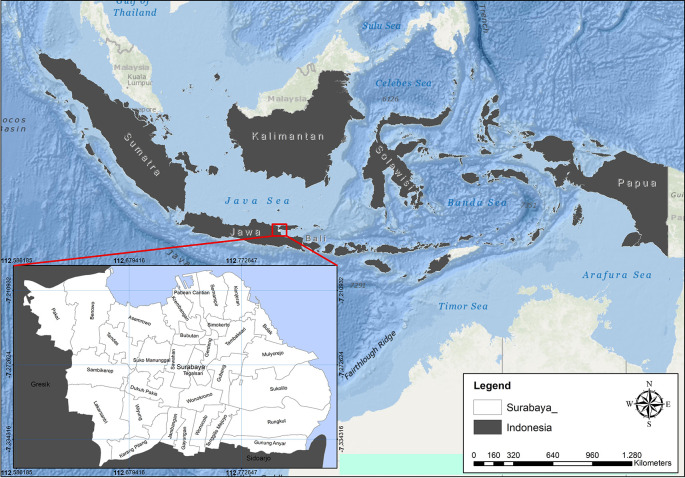 Figure 1
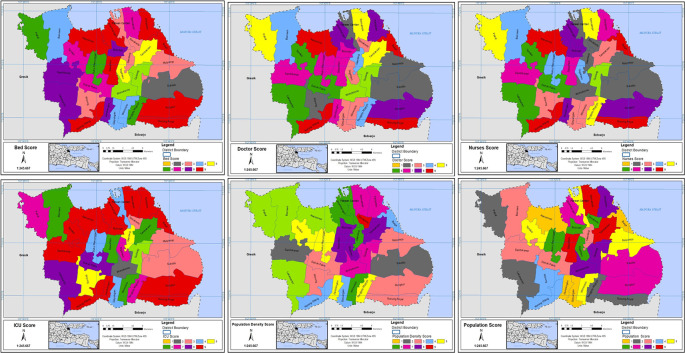 Figure 2
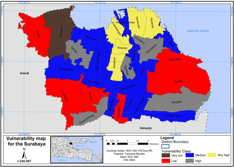 Figure 3
Peer Reviews
No public reviews on file for this paper yet. If you reviewed it on a platform where reviews are public (OpenReview, ICLR, NeurIPS, ICML), you can paste yours below so the community can read it here.
Videos
No videos yet. Explain this paper in a talk, walkthrough, or lecture? Add one.
Taxonomy
TopicsDisaster Management and Resilience · Flood Risk Assessment and Management