Grain-size distribution dataset of lagoonal and riverine coastal placer deposits along the southeastern coast of Sri Lanka
Chaturanga Sandaruwan, Nadeesha Madugalla, Madurya Adikaram, Amarasooriya Pitawala

TL;DR
This paper presents a dataset of grain size distributions from coastal sediments in Sri Lanka to study sediment dynamics and mineral deposits.
Contribution
The study provides a detailed grain size dataset for lagoonal and riverine placer and non-placer sediments along a 70 km Sri Lankan coastline.
Findings
Placer sediments show coarse-skewed leptokurtic to platykurtic fine sand distributions.
Non-placer sediments are characterized as medium sand-grained.
The dataset aids in understanding deposition environments and transportation dynamics.
Abstract
The dataset contains grain size data of placer and non-placer sediments in lagoonal and riverine beaches of southeastern part of Sri Lanka. A total of 124 swash sediment samples were collected from a 70 km long coastline with an interval of 500 m. Placer sediments in the area mainly have mineralogy of ilmenite, zircon and almandine while non-placers are quartz, albite and calcite. After dry sieving, the grain size distribution (GSD) analyses were carried out on each sample using the Gradistat Excel template. Placer deposits result coarse-skewed leptokurtic to platykurtic fine sand distributions while non-placers are medium sand-grained. The dataset can be used to interpret the deposition environment and transportation dynamics. Further, they can be used to study the southwestern coastline of the Bay of Bengal, juvenile crust sediments of Grenvillian age, alongshore and fluvial sediment…
Click any figure to enlarge with its caption.
 Figure 1
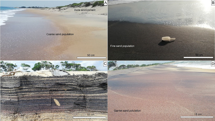 Figure 2
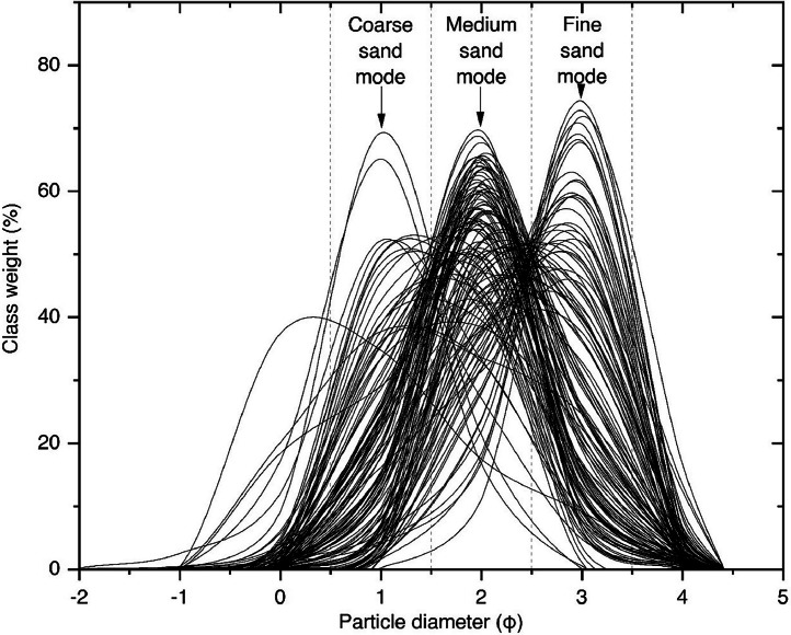 Figure 3
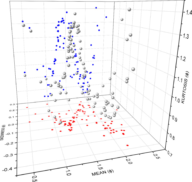 Figure 4
Peer Reviews
No public reviews on file for this paper yet. If you reviewed it on a platform where reviews are public (OpenReview, ICLR, NeurIPS, ICML), you can paste yours below so the community can read it here.
Videos
No videos yet. Explain this paper in a talk, walkthrough, or lecture? Add one.
Taxonomy
TopicsGeological formations and processes · Coastal and Marine Dynamics · Geochemistry and Elemental Analysis
Specifications TableSubjectEarth-Surface ProcessesSpecific subject areaVariations of grain size statical parameters between red, black placers and siliciclastic deposits; longshore, lagoonal and riverine depositType of dataTable, Graph, FigureRaw, Analyzed, FilteredData collectionFrom October 2019 to February 2020, 124 sediment samples were collected from the middle of the swash zone to depths of 15–30 cm. Here, a plastic shovel and zip lock bags and a 0.5 km station interval were used. In there, samples were occupied from black, red placers, and siliciclastic deposits. GPS coordinates were recorded, and samples were taken to a laboratory. The sample preparation involved processing 100 g of sediment fractions using the coning and quartering method, removing carbonate and salt coatings (10 % HCl and deionized water), and drying in an oven at 60 °C for 24 h. The sieving was performed using 1 ϕ interval ASTM sieves, Retsch vibratory sieve shaker (AS 200 digit), and laboratory analytical balance for 15 min. The grain size distribution parameters, their graphical analysis and mapping were evaluated using the Gradistat Excel template, Origin Pro (2021) and Arc GIS (10.8).Data source locationInstitution: Faculty of Applied Sciences, South Eastern University, Sammanthurai, 32,200, Sri LankaRegion: South Eastern coast of Sri LankaCountry: Sri LankaLatitude and longitude for collected sample: 7° 16′ 16.1′′ N – 81° 52′ 03.5′′ E and 6° 44′ 49.1′′ N – 81° 48′ 37.5′′ EData accessibilityRepository name: Mendeley DataData identification number: DOI: 10.17632/vzpxszhc8x.1Direct URL to data: https://data.mendeley.com/datasets/vzpxszhc8x/1Related research articleC. Sandaruwan, N. Madugalla, M. Adikaram, A. Pitawala, and T. Udagedara, “Microtexture and grain size characteristics of lagoonal and riverine coastal deposits along the southeastern coast of Sri Lanka: implication for paleoenvironment,” Arab. J. Geosci., vol. 16, no. 2, 2023, doi: 10.1007/s12517-022-11149-4. [1]
Value of the Data
1
- •The data pertains to unexplored heavy mineral placers in the southeastern coast of Sri Lanka.
- •The data focuses on the southwestern coast of the Bay of Bengal and examines variations in grain size distribution (GSD) [2].
- •Vijayan Complex, which is the basement and sediment source of study area, is related to the evolution of an island arc, juvenile crust of Grenvillian age, Lützow-Holm Bay region in East Antarctica [3,4].
- •The data show the GSD variations between the following: ilmenite, garnet placer deposits and siliciclastic sediment; crescent-shaped bays and straight beach sediment; numerous fluvial outlets and their gradual sinking distance increment on beach; and alongshore (∼70 km) beach sediments.
- •The data can be reused for the studies of alongshore and fluvial sediment dynamics, depositional and erosion processes, engineering applications, Precambrian host rock, renewable heavy minerals and Bengal Bay sediment.
- •The data can be beneficial to heavy mineral industries, sedimentologists, researchers, and civil engineers.
Background
2
The dataset was designed to distinguish grain size characteristics, sediment transport and depositional processes, and depositional environments of heavy placers from siliciclastic deposits. Also, the dataset can be used to understand the alongshore and fluvial sediment dynamics, nearshore coastal processes, coastal erosion, temporal variations, geohazards assessments and Bengal Bay sediments. This article presents raw data that are not included in the related research article. The raw dataset may be useful to researchers for creating cumulative passing presentation graphs and various bivariate graphs and statical analyses.
Data Description
3
In Fig. 1, symbols of the sample points are expressed as the mean values. Ilmenite placers of the area are denoted by the mean values > 2, while the Heda Oya deltaic environment shows the garnet deposits. Most of the placers can be found near fluvial outlets. The mean values of Akkaraipattu beach samples show an increasing trend towards the south direction. Fig. 2 shows the field photographs of the different deposits found in the study area.Fig. 1. Geological map of the study area shows the sampling locations, lagoonal and riverine environments.Fig 1. Fig. 2Examples of the sedimentary deposits from which the samples were taken. A) Siliciclastic deposits, B) and C) ilmenite placers and their vertical profile, and D) Garnet placers. The scale of plastic shovel is nearly 15 cm long.Fig 2
The main fluvial outlets of Gal Oya, Karanda Oya, Heda Oya and Wil Oya result in between SE1, SE99-SE100, SE111-SE112 and SE118-SE119, respectively. Mostly, scatter distribution of fine sand placers can be observed around the southern part of these fluvial outlets (Fig. 1). The heavy mineral contents of Komari and Periya Kalapuwa are observed to be higher black in color (Fig 2B-C). Whereas, the beach sector in between Heda Oya and Wila Oya shows a high amount of garnets by giving the red color nature to the beach (Fig. 2D). The mineralogy of the area's placer deposits consists primarily of ilmenite, zircon, and almandine, while non-placers include quartz, albite, and calcite [1].
As geomorphological observations, the northward development of spits with granitic gneiss rock boulders resulted along the nearshore areas of Sangamankanda to Panama beach. Further, the southern half of the present study area showed a higher number of coastal dunes. Retention of heavy mineral populations is observed to be on the berm zone or swash zone with a depth of ∼10–15 cm (Table 1).Table 1. Location data and grain size parameters of the samples in phi scale. The underlined and bolded mean values show the placers of the area.Table 1S. IDLatitudeLongitudeMean (Φ)Sorting (Φ)Skewness (Φ)Kurtosis (Φ)SE17.3017881.864562Akkaraipattu Straight Coastline1.66400.75800.06081.1634SE27.29951281.8648511.87480.74170.00810.8911SE37.29251981.8667210.77360.85300.09551.1142SE47.28770881.8669512.03990.6528−0.01830.7383SE57.28304681.8665931.30750.8381−0.02511.0028SE67.27115181.8676330.47391.07730.22340.9461SE77.26686581.8664780.97130.79320.24320.9015SE87.26087581.8654971.24410.7688−0.04041.0261SE97.25700281.8650631.31060.7274−0.06811.1949SE107.25278181.8645971.21180.7474−0.03740.9988SE117.24846481.8642191.22740.7382−0.06931.0341SE127.24455781.863931.06880.8270−0.01070.9626SE137.2396581.8637391.10440.8014−0.06540.9588SE147.23455881.8631811.27380.7053−0.09291.1346SE157.23024881.8625071.34090.7163−0.08381.3077SE167.22574981.8622271.33940.7633−0.08301.2846SE177.22114681.8622681.42230.6814−0.05001.3127SE187.2166481.8620941.32260.7252−0.07671.2405SE197.21237681.862106Periya Kalapuwa Deltaic Environment1.26170.6607−0.14191.1040SE207.207281.8621911.46540.76060.00011.3006SE217.20407681.8621581.56830.84180.02421.2625SE227.19857481.8622081.76260.67040.18011.0638SE237.19382681.8621611.53820.64230.05021.3747SE247.1892981.8618172.14430.79080.00450.9033SE257.18432181.8618511.31120.7242−0.08871.2417SE267.18001581.8615141.59020.68530.06631.2956SE277.17608181.8611851.81810.68560.15720.9228SE287.17175581.8611691.77120.68410.16941.0488SE297.16728681.8611841.32170.6254−0.12571.2433SE307.1633181.8612371.98310.67440.04190.7387SE317.15845181.8609952.25550.6013−0.26051.0235SE327.15323381.8607432.25120.5905−0.26801.0429SE337.14908581.8600642.16180.6664−0.22890.8571SE347.14532881.8592822.31970.6154−0.23211.2749SE357.14018781.8584151.17820.80140.07080.9221SE367.13592381.8578461.45640.7045−0.01551.3171SE377.13131281.8573382.06960.7688−0.21240.9144SE387.1263181.8571471.81380.69820.14110.9447SE397.12220981.8568561.81450.76540.12051.0017SE407.11887281.85863Korai Deltaic Environment2.22520.7683−0.05140.9710SE417.11343681.8584821.97630.72410.14130.8218SE427.10902981.8577591.64000.73420.09021.2759SE437.10452481.8577561.66840.73310.09801.2605SE447.10054181.8578381.74370.78440.02820.9797SE457.09453181.8597411.64230.72890.08551.2993SE467.0911681.8608331.96040.69410.14970.7931SE477.08719581.8618722.17370.6897−0.13810.9074SE487.0827381.8629052.36720.5726−0.16761.2403SE497.07861981.8633561.66040.9241−0.12220.8788SE507.07458581.8644341.22960.7624−0.07721.0209SE517.05553881.868139Sangamankanda Point1.61880.68240.09241.3380SE527.05205181.868409Coastline1.66640.76190.08921.2140SE537.04822981.8688912.01700.67970.07080.7769SE547.04298781.8701171.85270.7958−0.05380.9059SE557.03952581.8713511.25230.88030.11460.8968SE567.03528881.8746811.33640.8098−0.04681.1138SE577.03176981.8752570.97140.70540.10800.7908SE587.02682181.878181.74070.74260.07141.0456SE597.02243681.8786632.23880.6933−0.12431.0444SE607.01785281.8770541.02150.70350.12730.8298SE617.01430981.8757171.74770.69880.14911.1294SE627.00907381.8737321.93660.81100.00100.9320SE637.00574581.8731531.89820.68430.12860.7971SE647.00107781.8723571.91880.65680.10350.7490SE656.99671381.870407Komari Deltaic Environment1.52770.8800−0.01021.0107SE666.99287481.8682412.06630.6548−0.11620.7496SE676.98860781.866481.96590.72620.03160.8226SE686.98436781.8654482.02760.7435−0.23740.8779SE696.97999781.8649451.16380.7822−0.01760.9358SE706.97558381.8662021.67580.74770.07681.1993SE716.9712781.8667882.16460.7171−0.37081.1284SE726.96708481.8653641.83330.63990.22170.8252SE736.9637381.8649441.99020.7395−0.17940.8611SE746.9593581.8630072.22380.7230−0.11511.0282SE756.95476981.8611851.86490.9079−0.25430.8612SE766.95148981.859711Komari Straight Coastline1.87800.8387−0.11110.8815SE776.94750881.8580571.71220.8429−0.05640.9001SE786.94308281.8562922.09010.6786−0.23670.8263SE796.9386481.8543571.79580.8043−0.01060.9195SE806.93443181.8529671.97470.7732−0.18600.8817SE816.92886181.851831.77920.78770.05370.9998SE826.92474381.8502882.08120.6496−0.15670.7609SE836.92103681.848986Pottuvil Deltaic Environment2.03500.6672−0.06560.7408SE846.91609981.8471311.47570.7957−0.00191.1878SE856.91307381.8460951.73990.73800.07181.0464SE866.90727581.844281.31780.7237−0.06651.1769SE876.90372981.8445731.16730.77140.02650.9233SE886.89964681.8450481.88640.7709−0.10170.8947SE896.89699781.8475631.30210.6267−0.14841.1970SE906.89281981.8463442.01870.7653−0.18280.8697SE916.88811381.8440971.31980.6792−0.09941.2824SE926.8831681.8439931.08250.6599−0.14730.7584SE936.87897181.8450851.02620.72010.10170.8328SE946.87415881.8459161.27320.7155−0.15561.2681SE956.8705581.845088Arugam Deltaic Environment1.40190.6838−0.06351.3080SE966.86700981.8418521.70740.75590.09311.1467SE976.86340381.8387131.14640.7251−0.05280.9055SE986.86014981.8356190.50270.66530.00751.3145SE996.85611381.8331580.64800.62890.10731.2694SE1006.85177881.8319761.93890.6805−0.02000.7947SE1016.84723881.8318741.02360.6447−0.03810.7388SE1026.84331581.8322841.43260.6717−0.05941.3311SE1036.83952881.834892.27450.7151−0.22681.4059SE1046.83896881.8396461.96030.68700.11300.7673SE1056.83496181.8391152.54830.58890.02721.3374SE1066.83246381.835902Heda Oya Deltaic1.20750.7646−0.08491.0157SE1076.82896981.831941Environment1.44970.85150.00141.1497SE1086.82692681.8296530.93041.0179−0.11920.9848SE1096.8224981.8259440.93540.64760.05310.7412SE1106.81832481.8240071.74420.65630.16911.0984SE1116.81398981.8226721.35660.7732−0.04011.1251SE1126.80883681.8243081.17130.7832−0.04190.9411SE1136.80362481.8240461.62030.8885−0.04440.8885SE1146.8005981.8233392.08150.6487−0.18630.7704SE1156.79702581.8221091.73950.73690.05741.0509SE1166.79269781.8198961.98830.6959−0.14710.8208SE1176.78878981.818652.12200.6234−0.21040.7965SE1186.78433281.8190691.33720.92810.05470.8569SE1196.7634481.825404Wila Oya Deltaic Environment0.77860.99560.02180.9614SE1206.75982481.8226381.31760.7586−0.06571.1668SE1216.75659981.8191331.44690.8585−0.00191.1157SE1226.75375281.8163411.37220.7617−0.04041.2064SE1236.75100481.8135981.06560.71280.00780.8319SE1246.74697581.8104031.42960.96450.09980.7823
The mean grain size of the sediments varies from fine to coarse-grained sand with abundant medium sand (73.38 %). The sorting values are dominated by moderately sorted (55.64 %) to moderately well-sorted (42.74 %). Altogether, 58.87 % of samples showed near-symmetrical skewness. About 25 % of the samples showed coarse-skewed natures while fine-skewed are 16 %. On average, kurtosis values are resulted leptokurtic (35.48 %), mesokurtic (33.06 %) and platykurtic (31.45 %) natures.
In Fig. 3, distributions can be categorized into three modes such as coarse sand, medium sand and fine sand modes. Study samples abundantly show the medium sand populations, while most of the fine sand populations are related to the placers.Fig. 3. The plot shows the grain size distributions of samples.Fig 3
The plot shows the sediment population variations from fine, medium to coarse sand through a helical trend. Their bi-variations are projected in the figure in red and blue colours. A similar kind of plot resulted in the study of [5]. As in the mean vs. skewness projection, the studied samples show a zigzag trend that separates four skewed natures. The mean vs. kurtosis projection also shows the clustering of present samples within a sinusoidal trend (Fig. 4).Fig. 4. The tri-variate scatter plot shows the variation of mean, skewness and kurtosis of the samples.Fig 4
Experimental Design, Materials and Methods
4
Sediment sampling was carried out from October 2019 to February 2020 during the northeast-monsoon season. The sampling season was selected to relays with the higher fluvial outflow time. During the preliminary field visits, placers were recorded between 2 and 3 km near the coastline from fluvial outlets. Hence, the study area was classified into 10 segments based on the fluvial outlets, beach morphologies and depositions types, namely (i) Akkaraipattu Straight Coastline (18 sample points), (ii) Periya Kalapuwa Deltaic Environment (21 sample points), (iii) Korai Deltaic Environment (11 sample points), (iv) Sangamankanda Point Coastline (14 sample points), (v) Komari Deltaic Environment (11 sample points), (vi) Komari Straight Coastline (7 sample points), (vii) Pottuvil Deltaic Environment (12 sample points), (viii) Arugam Deltaic Environment (11 sample points), (ix) Heda Oya Deltaic Environment (13 sample points) and (x) Wila Oya Deltaic Environment (6 sample points). Sampling was designed to find the characteristics of different deposits and coastal types. As a final measure, a total of 124 sediment samples were collected at an interval of 500 m covering a distance of 68 km, from Oluvil to Panama coast (Fig. 1). During sampling, about 5 kg of sediments were collected from a small pit on the swash zone with an average depth of 15–30 cm in each sampling point. Plastic shovels and zip-lock bags were used to collect the samples. Field photographs and sampling locations were recorded at each point.
Before sieve analysis, the samples were air dried to make the grain free from trace moisture. Then, the dried sediment samples were subjected to coning and quartering to obtain representative samples. Carbonate material and salt coatings were removed by 10 % dilute hydrochloric acid and deionized water [6]. These sediment samples were oven-dried at 60 °C for 24 h [6]. Finally, sieve analyses were carried out by Retsch AS 200-digit model digital shaker at 1 phi intervals using ASTM sieves for 15 min [5]. Grain size distribution and graphical statistical parameters namely, mean, sorting, skewness and kurtosis were estimated using the Gradistat Excel template following the [5] method. The tri-bivariate scatter plots of the statistical parameters were plotted using Origin Pro (2021) to understand the relationship between different parameters [5].
Limitations
Due to the study's budget, the dataset could not capture seasonal variation. Due to coastal defence systems, regular sampling intervals at Akkaraipattu and Panama Beach were disrupted*.*
Ethics Statement
The current work does not involve human subjects, animal experiments, or any data collected from social media platforms.
CRediT authorship contribution statement
Chaturanga Sandaruwan: Conceptualization, Methodology, Software, Formal analysis, Data curation, Writing – original draft. Nadeesha Madugalla: Conceptualization, Validation, Resources, Writing – review & editing, Supervision. Madurya Adikaram: Conceptualization, Validation, Resources, Writing – review & editing, Supervision. Amarasooriya Pitawala: Conceptualization, Resources, Writing – review & editing, Supervision.
The reference list from the paper itself. Each links out to its DOI / PubMed record.
- 1Sandaruwan C.Madugalla N.Adikaram M.Pitawala A.Udagedara T.Microtexture and grain size characteristics of lagoonal and riverine coastal deposits along the southeastern coast of Sri Lanka: implication for paleoenvironment Arab. J. Geosci.162202310.1007/s 12517-022-11149-4 · doi ↗
- 2International Hydrographic Organization Limits of Oceans and Seas (Special Publication N° .28)3rd ed.1953 International Hydrographic Organization Monégasque - Monte-Carlo
- 3Kröner A.Kehelpannala K.V.W.Hegner E.Ca. 750-1100 Ma magmatic events and Grenville-age deformation in Sri Lanka: relevance for Rodinia supercontinent formation and dispersal, and Gondwana amalgamation J. Asian Earth Sci.223200327930010.1016/S 1367-9120(03)00060-9 · doi ↗
- 4Kehelpannala K.V.W.Arc accretion around Sri Lanka during the assembly of Gondwana Gondwana Res.74S 20044146
- 5Folk R.L.Ward W.C.Brazos river bar [Texas]; a study in the significance of grain size parameters J. Sediment. Res.271195732610.1306/74D 70646-2B 21-11D 7-8648000102 C 1865 D · doi ↗
- 6Rajmohan S.Hishamundavalens S.Venkatesan Claude N.Textural analysis and heavy mineral distribution studies of coastal sediments from Portonova to Gadilam River, Along the East Coast of Tamil Nadu Int. J. Geol. Earth Sci.232016334210.5281/ZENODO.1536875 · doi ↗