Assessing avian diversity and red squirrel occurrence in fragmented high-altitude mountain pine forests of the central French Pyrenees: A dataset of point counts
Michel Génard, Françoise Lescourret

TL;DR
This study collected data on birds and squirrels in mountain pine forests to understand how habitat fragmentation affects their populations.
Contribution
The paper provides a historical dataset from 1987 on avian diversity and red squirrel occurrence in fragmented high-altitude forests.
Findings
The dataset captures bird community composition and squirrel presence in relation to forest fragmentation.
It includes landscape and habitat variables like patch size, isolation, and vegetation structure.
The data serve as a baseline for future ecological comparisons and conservation studies.
Abstract
In the spring of 1987, point-count surveys of breeding birds (passerines and picidae) were conducted, resulting in a dataset of 197 counts. The purpose was to analyze the effects of forest fragmentation on bird community composition in a mountain pine forest located in the Néouvielle National Nature Reserve in the central French Pyrenees between 1800 and 2400 metres. The study aimed to differentiate between the impacts of landscape factors (patch area, isolation) and habitat characteristics (altitude, vegetation structure). Additional information was gathered regarding the presence of Common Crossbill (Loxia curvirostra), Great Spotted Woodpecker (Dendrocopos major), Red Squirrel (Sciurus vulgaris), and Capercaillie (Tetrao urogallus) in the forest. The sampling design ensured that the selected patches represented a wide range of sizes and distances to the nearest large pine patch or…
Genes, proteins, chemicals, diseases, species, mutations and cell lines named across the full text — each resolved to its canonical identifier and authoritative record.
Click any figure to enlarge with its caption.
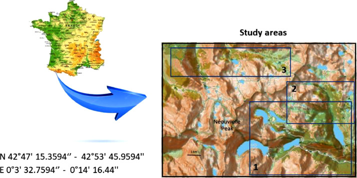 Figure 1
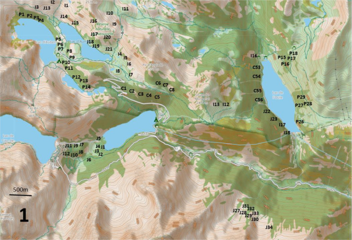 Figure 2
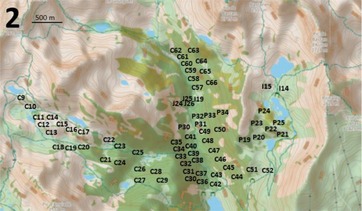 Figure 3
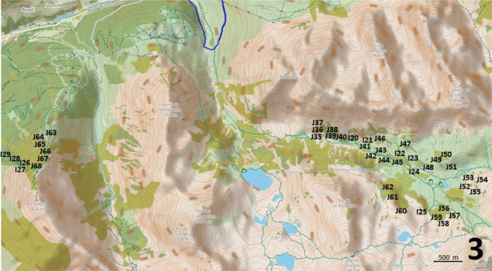 Figure 4
Peer Reviews
No public reviews on file for this paper yet. If you reviewed it on a platform where reviews are public (OpenReview, ICLR, NeurIPS, ICML), you can paste yours below so the community can read it here.
Videos
No videos yet. Explain this paper in a talk, walkthrough, or lecture? Add one.
Taxonomy
TopicsAnimal Ecology and Behavior Studies · Species Distribution and Climate Change · Ecology and Vegetation Dynamics Studies
Specifications TableSubjectBiologySpecific subject areaBiodiversityType of dataTableData collection20 min bird point-counts were conducted in the morning in spring within a distance of 50 metres around the observer. The presence of pine cones eaten by Common Crossbill, Great Spotted Woodpecker, Red Squirrel and Capercaillie droppings were also recorded at each point count. Within a 50-metre radius of each point count, the altitude, the percentage cover of open areas, of stones and boulders and of various vegetation layers, were estimated, along with the canopy height and the number of dead trees. The landscape variables, which included information on patch size and isolation from large pine stands or low-altitude forests, were determined using IGN maps and aerial photographs.Data source locationNéouvielle National Nature Reserve in the central French Pyrenees, FranceN 42°47′ 15.3594‘’ - 42°53′ 45.9594′', E 0°3′ 32.7594‘’ - 0°14′ 16.44′'(Fig. 1)Data accessibilityRepository name: Recherche Data Gouv https://entrepot.recherche.data.gouv.fr/dataverse/inraeData identification number: doi: 10.57745/AMIZQKDirect URL to data: https://entrepot.recherche.data.gouv.fr/dataset.xhtml?persistentId=doi:10.57745/AMIZQKRelated research articleLescourret F., Génard M. 1994. Habitat, landscape and bird composition in mountain forest fragments. Journal of Environmental Management, 40, 317-328. 10.1006/jema.1994.1025
Value of the Data
1
- •These data provide an overview of bird communities and Red Squirrel occurrences in the mountain pine forests of the central Pyrenees in the late 1980s.
- •Additionally, these data indicate the altitude, cover of open areas, stones, boulders and vegetation at different heights, canopy height and number of dead trees, which characterize the surveyed habitats, together with forest patch area and isolation.
- •These data can be valuable for researchers studying bird communities, biodiversity, Red Squirrel occurrence, and typical mountain species such as Capercaillie, and for conservation actors.
- •These data should be of interest to researchers concerned with the evolution of biodiversity or the abundance of species of interest since 1987 in mountainous areas, due to several drivers of change such as climate change or forest fragmentation. Each point count is marked on a map and new counts could easily be carried out at the same locations.
- •These data should be useful for biogeographical comparisons with other mountain or lowland sites in terms of bird communities and squirrel occurrence.
Background
2
The extent and pattern of mountain pine forests are limited by geomorphology, altitude, fire and grazing. As a consequence, pine forests are fragmented into patches of different size, surrounded by a more or less rocky grassland and by heaths. Pine fragmentation in Néouvielle, a massif in the central French Pyrenees, represents a current situation in high altitude forests. Pine forests are sometimes connected with low-altitude forests, which harbour silver firs (Abies pectinata L.), beeches (Fagus sylvatica L.) and larch (Larix decidua L.).
The surveys carried out give a good picture of the bird communities and squirrel occurrence in the fragmented mountain pine forests of the high Pyrenees at the end of the 1980s. The climate was colder then, and our data could be used as a reference for studies on the evolution of bird communities and squirrel occurrence as a result of climate change that has taken place in recent decades.
Interestingly, these data could be compared to those recorded in the early 1980s in mountain pine forests of the eastern Pyrenees [1].
Data Description
3
The dataset, which is available on Recherche Data Gouv [2], includes 197 records of Red Squirrel and breeding birds (“Neouvielle_signs_of_presence.tab” and “Neouvielle_birds.tab”) from mountain pine forests at altitudes between 1800 and 2400 m in the Néouvielle National Nature Reserve in the central French Pyrenees (Fig. 1 and “Neouvielle_maps.pdf”). A total of 16 birds’ species (14 by song and 2 by other signs of presence) were recorded in spring 1987 (Tables 1 and 2).Fig. 1. Location of the central Pyrenees and the three main study areas on the topographic map provided by openstreet map. The current forests are represented in green (this coverage may differ from that of 1987).Fig 1. Table 1Frequency of birds recorded using the point count technique (% of total point-counts).Table 1. NameFrequencyCoal Tit (Periparus ater)0.76Crested Tit (Lophophanes cristatus)0.27Goldcrest (Regulus regulus)0.36Common Chaffinch (Fringilla coelebs)0.66Eurasian Wren (Troglodytes troglodytes)0.02Eurasian Treecreeper (Certhia familiaris)0.04Eurasian Jay (Garrulus glandarius)0.02Great Spotted Woodpecker (Dendrocopos major)0.04Mistle Thrush (Turdus viscivorus)0.18Yellowhammer (Serinus citrinella)0.31Ring Ouzel (Turdus torquatus)0.07Dunnock (Prunella modularis)0.38Grey Wagtail (Motacilla cinerea)0.04Tree Pipit (Anthus trivialis)0.04Table 2Frequency of capercaillie droppings and pine cones consumed by birds and squirrels in 1986 (% of total point counts).Table 2. NameFrequencyCapercaillie (Tetrao urogallus)0.28Common crossbill (Loxia curvirostra)0.64Great spotted woodpeckers (Dendrocopos major)0.27Red Squirrel (Sciurus vulgaris)0.38
The altitude, cover of within-forest open areas, of stones, boulders and vegetation layers at different heights (<0.25 m, 0.25-0.5 m, 0.5-1 m, 1-2 m, 2-4 m, 4-8 m, 8-16 m, >16 m) were assessed within a 50m radius of the bird count site (Table 3). In addition, canopy height (m) and number of dead trees were recorded (“Neouvielle_habitats.tab”).Table 3. Habitat and landscape variables estimated for each sampling point.Table 3. CodeMeaningHabitat (within the 50m point-count radius)AltitudeAltitude (m)OpenCover of within-forest open areas (%)StonesCover of stones (<0.5m in diameter) (%)BouldersCover of boulders (> 0.5m in diameter) (%)L1Cover of vegetation layer <0.25 m (%)L2Cover of vegetation layer 0.25-0.5 m (%)L3Cover of vegetation layer 0.5-1 m (%)L4Cover of vegetation layer 1-2 m (%)L5Cover of vegetation layer 2-4 m (%)L6Cover of vegetation layer 4-8 m (%)L7Cover of vegetation layer 8-16 m (%)L8Cover of vegetation layer >16 m (%)Canopy heightCanopy height (m)Number of dead treesNumber of dead treesLandscapeAForest patch area (ha)DPDistance to the nearest large pine stand (km)DLADistance to the nearest low-altitude forest (km)
The forests are fragmented into patches of varying sizes surrounded by rocky grasslands and heaths. Some pine forests are connected with lower altitude forests. For each record, the area of the forest stand containing the record and the distance to the nearest low-altitude forest were estimated. Forest patches of more than 50 ha were classified as large. Then, for records in forest stands smaller than 50 ha, the distance to the nearest large pine stand was estimated, otherwise it was set to zero (“Neouvielle_fragm.tab”).
The meaning of the rows and columns in the four files of the dataset is explained in a readme file (“Readme.pdf”).
Experimental Design, Materials and Methods
4
Birds were sampled using the point-count technique [3] within a limited distance of 50 m around the observer. Singing passerines and picidae were recorded for 20 min in spring mornings under fair weather conditions (no wind or rain). The bird species were identified by expert ornithologists (F.L. and M.G.).
Due to an exceptionally low number of pine cones in 1987, the Common Crossbill, a typical bird of these forests, was absent. The occurrence of pine cones consumed by crossbills in the previous year was noted on the ground within 50 m around the observer, as well as those consumed by woodpeckers and squirrels. Capercaillie, which are difficult to count using the point count technique, were recorded as droppings within 50 m of the observer.
Points-counts were located in three areas of the Néouvielle National Nature Reserve (Fig. 1). Their positions are indicated on Fig. 2, Fig. 3, Fig. 4. Habitat descriptors were evaluated within a 50-metre radius of the point-count site. Plant cover was estimated through comparison with reference drawings depicting imaginary cover levels of 5 %, 10 %, and so on [4]. The altitude was measured using an altimeter and the IGN map at a 1:25,000 scale.Fig. 2. Location of the point-counts in the first study area.Fig 2. Fig. 3Location of the point-counts in the second study area.Fig 3. Fig. 4Location of the point-counts in the third study area.Fig 4
The values of the landscape variables, describing both patch size and isolation from either large pine stands or low-altitude forest, were evaluated from 1/25,000 IGN maps and from 1/20,000 IGN aerial photographs*.*
Limitations
Not applicable*.*
Ethics Statement
The authors have read and follow the ethical requirements for publication in Data in Brief and confirm that the current work does not involve human subjects, animal experiments, or any data collected from social media platforms*.*
CRediT authorship contribution statement
Michel Génard: Data curation, Writing – original draft. Françoise Lescourret: Data curation, Writing – original draft.
The reference list from the paper itself. Each links out to its DOI / PubMed record.
- 1Génard M.Lescourret F.Census of breeding birds in the Pyrenees in the early 1980 s: a publicly available dataset for ecological research Data Brief 50202310.1016/j.dib.2023.109619 PMC 1056214237823066 · doi ↗ · pubmed ↗
- 2F. Lescourret, M. Génard, Census of breeding birds in fragmented high-altitude mountain pine forests of the Central French Pyrenees in 1987. Recherche Data Gouv (2024), 10.57745/AMIZQK.
- 3Blondel J.Ferry C.Frochot B.Point counts with unlimited distance Stud. Avian Biol.61981414420
- 4Prodon R.Lebreton J.D.Breeding avifauna of a Mediterranean succession: the holm oak and corn oak series in the eastern Pyrenees. 1. Analysis and modelling of the structure gradient Oikos 3719812138