Efficient geospatial mapping of buildings, woodlands, water and roads from aerial imagery using deep learning
Sidra Abbas, Ahmad Almadhor, Gabriel Avelino Sampedro, Shtwai Alsubai, Abdullah Al Hejaili, Ľubomíra Strážovská, Monji Mohamed Zaidi

TL;DR
This paper presents a deep learning approach for efficiently mapping land cover features like buildings and roads from aerial images.
Contribution
The study introduces a novel deep learning pipeline that improves the accuracy and speed of land cover classification in aerial imagery.
Findings
The DeepLabV3 ResNet50 model achieved the highest accuracy of 94.77% for land cover classification.
The proposed approach outperformed traditional UNet models in prediction scores across all classes.
ResNet50 UNet and DeepLabV3 ResNet50 models showed better performance metrics than Vanilla-UNet.
Abstract
As more aerial imagery becomes readily available, massive volumes of data are being gathered constantly. Several groups can benefit from the data provided by this geographical imagery. However, it is time-consuming to manually analyze each image to gain information on land cover. This research suggests using deep learning methods for precise and rapid pixel-by-pixel classification of aerial imagery for land cover analysis, which would be a significant step forward in resolving this issue. The suggested method has several steps, such as the augmentation and transformation of data, the selection of deep learning models, and the final prediction. The study uses the three most popular deep learning models (Vanilla-UNet, ResNet50 UNet, and DeepLabV3 ResNet50) for the experiments. According to the experimental results, the ResNet50 UNet model achieved an accuracy of 94.37%, the DeepLabV3…
Genes, proteins, chemicals, diseases, species, mutations and cell lines named across the full text — each resolved to its canonical identifier and authoritative record.
Click any figure to enlarge with its caption.
 Figure 1
 Figure 2
 Figure 3
 Figure 4
 Figure 5
 Figure 6
 Figure 7
 Figure 8
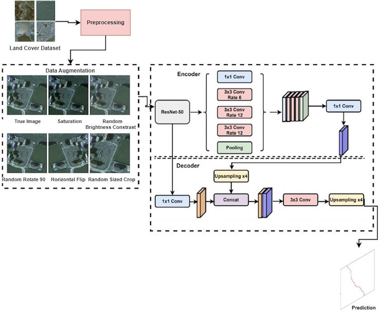 Figure 9
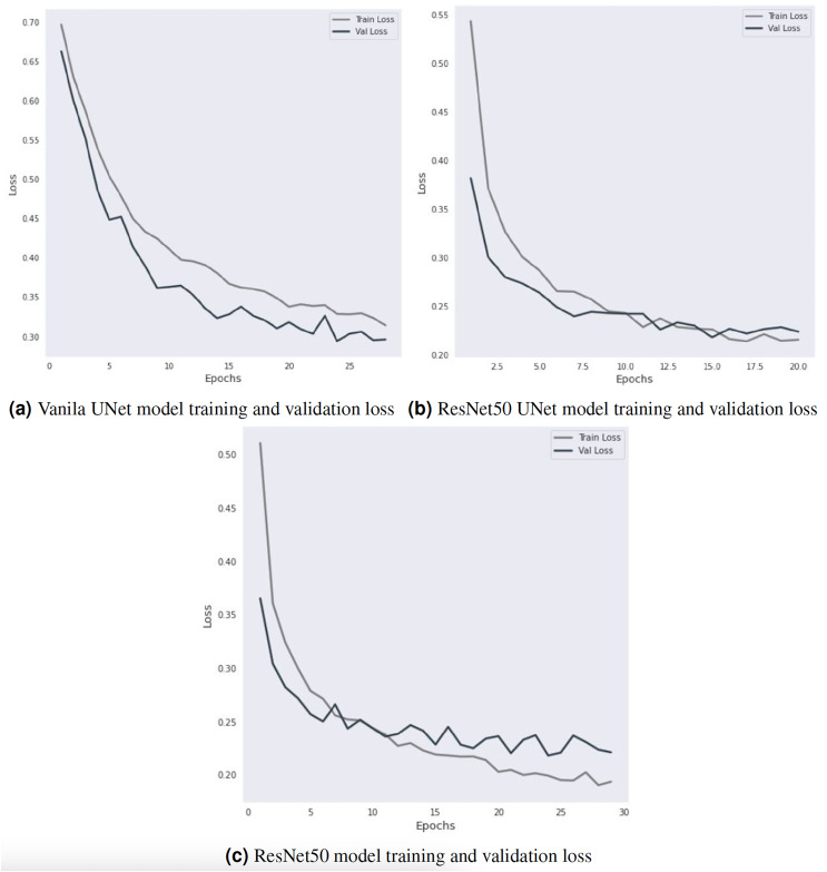 Figure 10
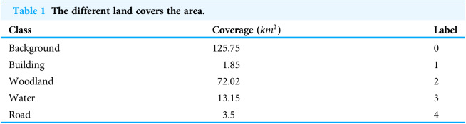 Figure 11
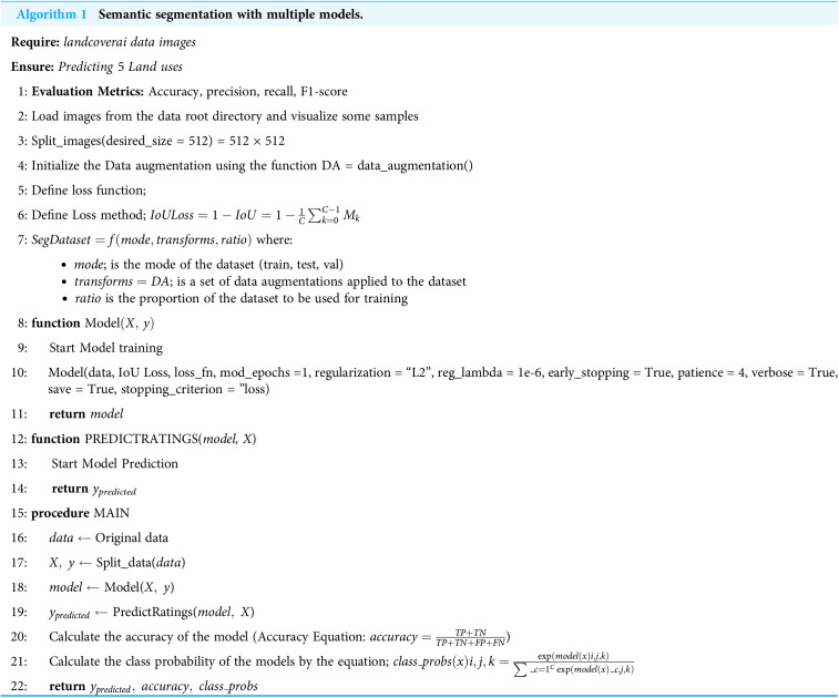 Figure 12
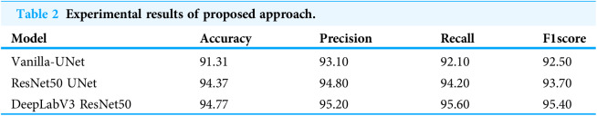 Figure 13
 Figure 14
 Figure 15
 Figure 16
 Figure 17
 Figure 18
 Figure 19
 Figure 20
 Figure 21
 Figure 22
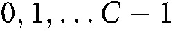 Figure 23
 Figure 24
 Figure 25
 Figure 26
 Figure 27
 Figure 28
 Figure 29
 Figure 30
 Figure 31
 Figure 32
 Figure 33
 Figure 34
 Figure 35
 Figure 36
 Figure 37
 Figure 38
 Figure 39
 Figure 40
 Figure 41
 Figure 42
 Figure 43
 Figure 44
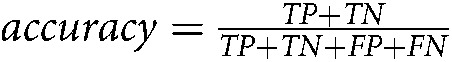 Figure 45
 Figure 46
 Figure 47
Peer Reviews
No public reviews on file for this paper yet. If you reviewed it on a platform where reviews are public (OpenReview, ICLR, NeurIPS, ICML), you can paste yours below so the community can read it here.
Videos
No videos yet. Explain this paper in a talk, walkthrough, or lecture? Add one.
Taxonomy
TopicsAutomated Road and Building Extraction · Remote-Sensing Image Classification · Remote Sensing and LiDAR Applications